Our friends at Boulder County Parks and Open Space have a new ongoing volunteer opportunity monitoring shrub habitats. Boulder County has abundant shrub habitats in varying conditions at their foothills properties (Hall Ranch, Heil Valley Ranch, Rabbit Mountain).
Monitors will track shrub health relative to climate, browsing, and fire interval on Boulder County open space properties. Some general qualifications include knowledge of plant identification or natural resources background, experience with line and point transect monitoring, scientific method and the ability to keep computer records.
For more information about this opportunity, visit this page (scroll to the bottom of the document), or contact Michael Bauer at mbauer@bouldercounty.org, 303-678-6219.
The Colorado Natural Heritage Program recently did an extensive county-wide inventory of Boulder County. Our report, Survey of Critical Biological Resources in Boulder County, Colorado, is availabe on our reports page, under "2009 Documents and Reports".
Thursday, October 29, 2009
Tuesday, October 27, 2009
Following pallid bats in canyonlands of southeastern Colorado

Pallid bat (Antrozous pallidus) with attached telemeter (gleaming line behind the bat is the antenna from the transmitter)
The pallid bat (Antrozous pallidus), like most bats in North America, feeds on invertebrates, but pallid bats are one of the few that takes a considerable proportion of their meals off the ground or vegetation. Pallid bats can sometimes be found landing on the ground to capture and eat terrestrial arthropods, like scorpions, centipedes, spiders and grasshoppers. Pallid bats are mainly nocturnal, and during the day can roost in large aggregations of hundreds of individuals. Most often, however, day roosts contain solitary bats or small groups of individuals in caves, mines, cracks or buildings.

Jeremy Siemers sitting above a boulder where a pallid bat is roosting (the bat is in the crack in the foreground)
CNHP Zoologists Rob Schorr and Jeremy Siemers spent this summer trying to determine what areas male pallid bats use during the day. As the sun set near the Purgatoire River in Las Animas County, Rob and Jeremy extended mistnets over cattle troughs in hopes of catching bats flying in for a drink. Twelve male pallid bats were captured over several troughs, and Rob and Jeremy carefully attached radiotelemeters to each one. The radiotelemeters emitted high frequency sound that could be tracked using specialized antennas and receivers.

Rob Schorr and telemetered pallid bat
Rob, Jeremy, graduate student Jessica Healy, and technician Catherine Gearhart tracked these 12 pallid bats to approximately 50 roosts. Most of these roosts were in tall, vertical cracks in rock wall cliffs, but a few were in the cracks of large boulders. Some roosts were home to multiple bats and on two occasions one of the telemetered bats was found using a roost previously occupied by another telemetered bat. What became apparent over the course of tracking the pallid bats is that the bats selected cliff roosts that were difficult for humans to access. On more than one occasion researchers had to backtrack after reaching perilous cliff walls or drop-offs. As Rob and Jeremy analyze this summer's data, it will be interesting to discover if the roosts of these 12 bats display similar characteristics.

Jeremy Siemers peers from one of the cliff wall cracks near a pallid bat roost
Thursday, October 22, 2009
North Platte Watershed Wetland Assessment crew wraps up field season
CNHP ecologist Denise Culver and her colleagues spent a good part of the summer in Jackson County in north-central Colorado, looking at important wetlands of the North Platte watershed. The study was funded by the North Platte Basin Roundtable and the Colorado Water Conservancy Board and was designed to assist the Roundtable’s Non-consumptive Needs Assessment committee in meeting their overall goal of identifying important non-consumptive uses in the watershed. “Non-consumptive use” means water used to support wildlife, recreation (fishing, hunting, wildlife viewing, boating) and habitat, as opposed to “consumptive use” which has historically been used to mean water used for agricultural, municipal and industrial benefits.

The survey will provide the citizens of the North Platte River Watershed with scientific data on the range of wetland dependent plants and animals. These results can be used to assist land use planning and management efforts and to balance the needs of natural resources and water developments. Additionally, the results from individual properties can be utilized by the landowners as a baseline for future conservation options.

The North Platte watershed supports every wetland type known in the Southern Rocky Mountain ecoregion, including riparian wetlands (willow carrs), fens (peat accumulating and ground water fed), alkaline flats, and freshwater marshes. These wetland complexes are presently intact and contiguous, providing migration corridors and habitat for animals (including aquatic vertebrates and invertebrates). Prior to the project, very little was known about the wetlands on private lands within the watershed.


To date, CNHP has had access to over 186,000 privately owned acres, or about 44% of the private land in the watershed. Preliminary results confirm the importance of private lands that support intact, contiguous wetlands in excellent condition. These wetlands make important contributions to the health of aquatic systems by purifying water, filtering runoff, abating floods, and decreasing erosion, as well as providing habitat for wildlife, fish, waterfowl, and amphibians. During the course of the summer we met many landowners and managers who are concerned about the future of the North Platte and its tributaries. Their best management practices, already in place, indicate good stewardship of their lands and water, which is important not only for their property but also for private and public lands downstream.


Denise digging a soil pit, or a mud pit, as the case may be.

A family of badgers wonders what an old survey flag is doing in the middle of their territory (sorry guys).
The North Platte watershed supports every wetland type known in the Southern Rocky Mountain ecoregion, including riparian wetlands (willow carrs), fens (peat accumulating and ground water fed), alkaline flats, and freshwater marshes. These wetland complexes are presently intact and contiguous, providing migration corridors and habitat for animals (including aquatic vertebrates and invertebrates). Prior to the project, very little was known about the wetlands on private lands within the watershed.

Example of a fen in the North Platte watershed.

A pair of sandhill cranes hanging out in a wet meadow.
Migration corridors are extremely important for these and many other birds.
Migration corridors are extremely important for these and many other birds.
To date, CNHP has had access to over 186,000 privately owned acres, or about 44% of the private land in the watershed. Preliminary results confirm the importance of private lands that support intact, contiguous wetlands in excellent condition. These wetlands make important contributions to the health of aquatic systems by purifying water, filtering runoff, abating floods, and decreasing erosion, as well as providing habitat for wildlife, fish, waterfowl, and amphibians. During the course of the summer we met many landowners and managers who are concerned about the future of the North Platte and its tributaries. Their best management practices, already in place, indicate good stewardship of their lands and water, which is important not only for their property but also for private and public lands downstream.

A young boreal toad makes a break for its wetland home...

…while a juvenile wood frog contemplates its options.
Tuesday, October 20, 2009
Preble's meadow jumping mouse at the U.S. Air Force Academy

A Preble's meadow jumping mouse (Zapus hudsonius preblei) after being released
For 12 years, the Colorado Natural Heritage Program has been helping the U.S. Air Force Academy monitor and manage the populations of Preble's meadow jumping mice (Zapus hudsonius preblei) found on the Academy. One tool CNHP is using is a long-term mark-recapture study of the Preble's mouse population inhabiting the riparian shrublands along Monument Creek.

Monument Creek and the adjacent shrublands inhabited by Preble's meadow jumping mice
Each summer researchers return to the same sections of Monument Creek to capture and mark individual Preble's mice. By marking new individuals and recapturing previously tagged individuals, researchers can estimate population parameters, such as survival and abundance. This year, CNHP zoologist and project lead Rob Schorr was accompanied by zoologist Bobby Weidmann and volunteer Molly McGee. Rob has been coordinating the trapping since its inception in 1999, and Bobby returned to the Academy after helping Rob sample in 2004 and 2005. Molly made her first visit to the Academy while on summer break from Furman University in Greenville, South Carolina.

Molly McGee and Rob Schorr in the shrublands of Monument Creek

Rob Schorr pointing out the distinctive large hind feet and long tail of the Preble's meadow jumping mouse
Thursday, October 15, 2009
Rocky Mountain ReMAP project

The multi-state ReMAP project team lays out a survey plot during pre-season training in Lander Wyoming.
CNHP is partnering with the Montana Natural Heritage Program and the Wyoming Natural Diversity Database on an exciting large-scale project that will aid all three states in refining wetland condition assessment methodology. The project, funded by the EPA’s Regional Monitoring and Assessment Program (ReMAP for short), is called the Rocky Mountain ReMAP project and provides an opportunity to compare wetlands across the Rocky Mountains.

Over the course of the three-year project period (2008-2011), the project will:
1. Identify reference standards for six wetland ecological systems found across the Rocky Mountain region
2. Develop Level I, II and III protocols for evaluating the ecological condition of six wetland ecological systems throughout the study area.
3. Produce a regionally standardized method for assessing and monitoring wetland condition, including quality assurance project plans, sampling strategies, and metrics calibrated to the six different wetland ecological systems.

Linda Vance, project lead from the Montana Natural Heritage Program, discusses protocols for estimating bankfull width during pre-season training in Lander, Wyoming.
Data collection for this project began this past field season, and will continue through next year. The CNHP field crew traveled to wetlands throughout the mountainous portions of Colorado, including the West Elk Mountains near Gunnison, the Sawatch Range near Buena Vista, and the Mt. Zirkel Wilderness near Steamboat Spring. Though they put many miles on the field vehicle, CNHP crew members Elin Franzen and Hannah Varani, both recent CSU graduates, were thrilled to see so many different and beautiful wetlands across the state.

CNHP ReMAP field crew member Elin Franzen prepares to survey a high elevation marsh in Chaffee County.
Tuesday, October 13, 2009
Renée Rondeau receives award from CSU
CNHP Ecologist and Conservation Planning Team Leader, Renée Rondeau, was presented with an award on October 6 for her outstanding role as Staff Co-Chair for the 2008-2009 CSU Faculty-Staff Drive. This annual fund drive raises money for important CSU programs, including non-profit programs within the University, such as the Colorado Natural Heritage Program. It also provides a critical yardstick for outside funding agencies to evaluate how well those of us within the University believe in and advocate for the opportunities we offer.

As Staff Co-Chair, Renée shared why she believes Colorado State University is such a wonderful place to work, teach, and learn. She visited donors, thanking them personally for their contributions to CSU, as well as voicing her support in the Drive brochure and thank-you letters.
"It was a true pleasure working with her." said Sara Colorosa, Assistant Director of Annual Giving for CSU, who presented Renée with the award during CNHP's most recent staff meeting.


From left to right: Ken Wilson, Fish, Wildlife, & Conservation Biology Department Head; Warner College of Natural Resources Dean Joe O'Leary; Renée Rondeau; Sara Colorosa, Assistant Director of Annual Giving, University Development; and Scott Webb, WCNR Director of Development.
As Staff Co-Chair, Renée shared why she believes Colorado State University is such a wonderful place to work, teach, and learn. She visited donors, thanking them personally for their contributions to CSU, as well as voicing her support in the Drive brochure and thank-you letters.
"It was a true pleasure working with her." said Sara Colorosa, Assistant Director of Annual Giving for CSU, who presented Renée with the award during CNHP's most recent staff meeting.

Renée tells Scott Webb and Sara Colorosa why she is passionate about her work and why charitable giving for causes you believe in is so important.
Thursday, October 8, 2009
CNHP awarded EPA Wetland Program Grant

We are thrilled to announce that CNHP has been awarded $550,832 from the U.S. Environmental Protection Agency (USEPA), Region 8, Wetland Program Development Grant Program. The award funds three projects that support EPA’s Strategic Plan and contributes to Colorado’s Wetlands Strategy.
The first project, Tools for Colorado Wetlands: Essential Information for Identification, Assessment, and Conservation, will develop a Colorado Wetland Field Guide that will contain botanical descriptions of over 500 wetland plants as well as information on priority wildlife species and other wetland-dependent animals, wildlife and vegetation ecology, and rare and/or sensitive plants. The Guide will serve as the ultimate resource to determine a wetland plant’s identity, wetland indicator status, coefficient of conservation, rarity, and ecology. The project will also develop an easily accessible Colorado Wetland Website that will provide a virtual “one-stop shopping” for wetland information in Colorado, including:
- Information on wetland ecosystems and their conservation status,
- a database to calculate the overall conservatism of species present in a wetland,
- reports on Colorado wetland and wetland assessment tools, and
- links to other wetland projects and programs

The second project, Setting Mitigation in the Watershed Context: Developing a Multi-tiered Approach to Improve Compensatory Mitigation will be conducted in partnership with CSU’s Department of Biology. This project will develop protocols for improving compensatory mitigation decisions by placing them within a whole watershed context, considering both gross changes to the abundance of wetland types and the condition of existing wetlands. A pilot study area will include a key portion of the rapidly developing northern Front Range I-25 corridor. This project will create:
- A rational framework for developing wetland profiles throughout Colorado for mitigation purposes,
- mapping and trend analysis of wetland cumulative impacts, along with characterization of current wetland condition within the pilot study area, and
- a general framework for placing mitigation in the landscape context in Colorado.

The third project, Survey of Critical Wetlands and Riparian Areas in Teller County, will build upon CNHP’s effort to document and assess Colorado’s rare and/or imperiled plants, animals, and unique plant communities since 1992. This project, in partnership with Teller County and the Coalition for the Upper South Platte (CUSP), will perform a prioritized survey and conditional assessment of the County’s wetlands, including geographically isolated wetlands. The survey will provide a proactive approach for land managers and decision makers in rapidly growing areas within the County.
10/28/2009 Update: Here is the official press release from CSU.
Tuesday, October 6, 2009
Basinwide Wetland Profile of the North Platte River Basin

CNHP Wetland Ecologist and project lead, Joanna Lemly and field volunteer Alexandra Permar discuss hydric soil indicators in a wetland in North Park.
CNHP’s Ecology Team initiated Colorado’s second basin-wide wetland condition assessment this August. Following the success of the pilot Rio Grande Headwaters Wetland Condition Assessment, this second EPA-funded project is focused on the North Platte River Basin in north central Colorado. The project will create a wetland profile of the North Platte River Basin, documenting the spatial distribution of wetland types and ecological condition, and will relate that information to potential threats and stressors.

Wetland identification and condition assessment protocols include a full description of the soil profile. Joanna finds the exact soil color in her Munsell Soil Color Chart.
The project objectives are to (1) compile existing spatial data on wetlands in the North Platte River Basin; (2) conduct a statistically valid, field-based survey of wetland condition in the basin; and (3) model the distribution of wetland condition throughout the basin using collected field data and additional spatial data on potential threats and stressors. This information is necessary to prioritize on-the-ground efforts for efficient and effective conservation and management.

Joanna attempts to dig a soil pit in a wetland outside Walden, Colorado. Some soil pits are harder to dig than others!
Last winter, GIS Analysts with CNHP and the Colorado Division of Wildlife compiled all known sources of wetland mapping for the North Platte River Basin. We also acquired existing paper maps of wetlands created in the 1970s and 80s by the US Fish and Wildlife Service’s National Wetlands Inventory (NWI). These paper maps were scanned in and digitized to create a seamless, wall-to-wall map of wetlands in the basin. From this map, 100 randomly selected sample points were used for the wetland condition assessment.

The available digital NWI data went from this…

...to this!
This is a two phase project. In August, 10% of the sample points were visited and assessed using methods developed at CNHP. These sites will be revisited, along with the remaining points, during the 2010 summer field season. The initial 2009 data collection will allow us to estimate inter-annual variability associated with the assessment methods. This field season also gave the project team an opportunity to explore the basin and its many wetlands in order to ensure that the study design would be successful.
Thursday, October 1, 2009
Shale Barrens
From Cañon City in southeastern Colorado to the Kansas and New Mexico borders lies an area of marine rocks dating back to the Cretaceous, exposed by the inexorable erosional processes of the Arkansas River. These exposed shales and soft limestones (chalk) form outcrops of an interesting and important habitat type – shale barrens.
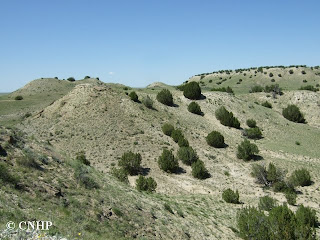
CNHP ecologist Renée Rondeau has been documenting these habitats in Las Animas, Pueblo, and Huerfano Counties this past summer. These habitats are extremely vulnerable to surface disturbance such as mining, quarrying, and other activities that lead to changes in soil structure or vegetation structure.
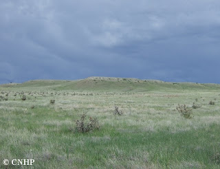
The area between Pueblo and Cañon City contains the highest frequency of such shale barrens in southeastern Colorado. Forming low hills above the surrounding shortgrass prairie, the barrens typically have a high percentage of open, rocky ground and sporadic vegetation. Some occurrences have an overstory of sparse juniper and/or pinyon pine, and may include scattered larger shrubs and bunchgrasses. Shale substrates often form a rocky “pavement” between plants.
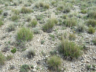
A number of Colorado’s rare plant species are found on shale barrens, especially on substrates formed from the Smoky Hills Member of the Niobrara Formation. Some may also occur on the Fort Hayes member of the Niobrara, or occasionally on substrates derived from adjacent Cretaceous formations such as the Carlile Shale, Greenhorn Limestone, and Graneros Shale.


Shale barrens aren't really barren, but no one would
call them lush with vegetation, either.
Photo by Renée Rondeau
call them lush with vegetation, either.
Photo by Renée Rondeau
CNHP ecologist Renée Rondeau has been documenting these habitats in Las Animas, Pueblo, and Huerfano Counties this past summer. These habitats are extremely vulnerable to surface disturbance such as mining, quarrying, and other activities that lead to changes in soil structure or vegetation structure.

Shale barren outcrops rising out of the prairie.
Photo by Renée Rondeau
Photo by Renée Rondeau
The area between Pueblo and Cañon City contains the highest frequency of such shale barrens in southeastern Colorado. Forming low hills above the surrounding shortgrass prairie, the barrens typically have a high percentage of open, rocky ground and sporadic vegetation. Some occurrences have an overstory of sparse juniper and/or pinyon pine, and may include scattered larger shrubs and bunchgrasses. Shale substrates often form a rocky “pavement” between plants.

Clumps of little bluestem scattered through shalely soils.
Photo by Renée Rondeau
Photo by Renée Rondeau
A number of Colorado’s rare plant species are found on shale barrens, especially on substrates formed from the Smoky Hills Member of the Niobrara Formation. Some may also occur on the Fort Hayes member of the Niobrara, or occasionally on substrates derived from adjacent Cretaceous formations such as the Carlile Shale, Greenhorn Limestone, and Graneros Shale.

Geology lesson: The Niobrara Formation (yellow) and Carlile Shale,
Greenhorn Limestone, and Graneros Shale formations (brown) in southeast Colorado.
Greenhorn Limestone, and Graneros Shale formations (brown) in southeast Colorado.
For more information, read CNHP's shale barrens ecological system description (PDF). Other ecological system descriptions are available on our website.
Subscribe to:
Posts (Atom)
