Tuesday, December 28, 2010

Ecological Systems: Foothills Shrubland

example of foothills shrubland

Foothill shrublands in Colorado are found in the Rocky Mountain foothills, ridges, canyons and lower mountain slopes, and on outcrops, mesas, and canyon slopes of the eastern plains. In general, these are mixed shrublands of areas where oak is absent, most common in the northern Colorado Front Range and drier foothills and prairie hills. Elevations are between 4,900-9,500 ft. Scattered trees may be present, but the vegetation is dominated by a variety of shrubs such as mountain mahogany, antelope bitterbrush, skunkbush sumac, or currant species. The dominant shrub species are generally well adapted to poor soils, dry sites, and disturbance by fire. Fire suppression may have allowed an invasion of trees into some of these shrublands, but in many cases sites are too dry for tree growth.

These shrublands are used by bird species including rufous-sided and green-tailed towhees, MacGillvray's warbler, and broad-tailed hummingbird. A number of small mammal species are common in this habitat, including the rock squirrel, deer mouse, northern rock mouse, Mexican woodrat, and gray fox. There are few rare species exclusively associated with foothills shrublands, although they may be important for some insect and bird species. Rare species in adjacent habitats that may be found in these shrublands include the Columbian sharp-tailed grouse, Larimer aletes, and rare butterflies.

Spermophilus variegatus
A rock squirrel (Spermophilus variegatus) doing its best to blend in.

These shrublands cover less than 400,000 acres in Colorado. Our occurrences are generally in good condition, but underrepresented in protected areas. Most of these shrublands are on privately owned lands, although some large occurrences have been protected on city or county open spaces. Threats to this system include fragmentation by roads and development. These disturbances provide an unnatural fire break as well as a conduit for weed invasion.

Overall biodiversity, threat, and protection status scores for foothills shrubland in Colorado.

A "windrose" graph depicting foothills shrubland status for individual scoring factors.

Wednesday, December 22, 2010

Happy Holidays from CNHP

From our family to yours, we hope you have a peaceful and happy holiday season.

pretty snow covered mountain scene
Red Mountain, photo by Peggy Lyon

The blog will be back in business in January, see you then!

Thursday, December 16, 2010

Air It out

By Erick Carlson, CNHP Wetland Ecologist and Mapper

As ecologists, we are always searching for a new perspective, an angle that sheds light on the complexities of ecosystems. Sometimes that involves nose to the ground rummaging, tree climbing, spelunking, or in my case, flying. A wholly unnatural pursuit (especially for me), flying really emphasizes the connectedness of landscapes, mosaics of vegetation patterns, and the undeniable effect human use has had on the surface of the land.

I was in the thick of assessing the accuracy of remote wetland classification and map production on two projects along the Front Range. It’s a big area with less public access than I needed to really get a grip on all the wetland types in the area. While I had visited some areas on the ground, I needed a more efficient method to visit many types of wetlands, without trespassing. So - I got to go FLYING! This was made possible through the LightHawk organization that coordinates flight time with pilots willing to donate their skills and planes to groups that would benefit from a little aerial perspective. Our wonderful pilot David gave myself, Joanna Lemly (Wetland Ecologist at CNHP), and a member of the Save the Poudre Coalition Board a tour of the Poudre and South Platte River corridors east of the Foothills. 

Here we are loading into the plane, a squish-ably comfy 4 seater. 

Lift off! This little plane is the ”jeep” of aircraft, taking off and landing in something like 200 ft. of runway, or if there is no runway, anything flattish. Below are some nice man-made “wetlands” at a golf course as we climbed to our cruising altitude of 500-1000 ft.


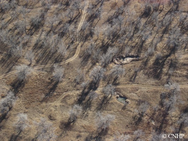
We headed east scouring the land below us as our pilot kept the plane steady and slightly tilted to the right so I could examine the wetland features while Joanna snapped hundreds of pictures like these from the back seat. 


The ride was smoother than expected, but the further east we traveled the more the Colorado wind decided it wanted to join the party. While it was not overly turbulent, it was enough to impair my ability to concentrate. We made an unscheduled stop in Brush, CO for a pit stop and to get our “land legs” back under us. While this was a nice break, I soon realized I was past the point of no return. Ten minutes back in the air and..…well..…let's just say I revisited previous meals. The next hour and a half flight back was less fun than the hour out, but David pulled us up to 1000+ feet which smoothed out the ride a bit. 

So why were we flying over the plains in December to look at wetlands? The timing just worked out that way, but actually yielded a few unforeseen benefits and a few surprises. First, although I use aerial photographs to map the wetlands in the first place, these are all taken looking straight down. By flying around we were able to get the 3D version of the landscape and use the oblique (slightly from the side) perspective to really get some good information about scale and topography. Secondly, without leaves on the trees (cottonwoods mostly) the understory becomes visible.


 This is important for deciding how wet an area is by how vigorous the vegetation growth is. The biggest surprise was, while December is a pretty low water time for river systems in Colorado, there was some extensive flooding in certain fields. It seemed like an odd time to be irrigating, so we are wondering what is happening here. 


While the flight time of three hours round trip was nothing extraordinary, I needed the full day and night to recover. I guess people get used to it, but I was having some difficulty. But the trip was a huge success as I was able to narrate about the wetlands to the passengers, discuss with Joanna (while in the air) troublesome patterns and specific features, and utilize the 386 pictures taken to further the accuracy of the areas I had been mapping. Joanna was gracious enough to not take a picture of me after the ride, lest viewers think I was a dancer in Michael Jackson’s Thriller. 

A big thank you goes out to our pilot David for his time, effort, and supply of ziplock bags, Lighthawk for their organization and what they do for the sciences, Joanna for her tolerance and strong stomach, and our STPC board member Greg for his company and questions.

Tuesday, December 14, 2010

National Wetlands Monitoring & Assessment Presentation

CNHP Wetland Ecologist Joanna Lemly just returned from North Carolina, where she presented to EPA’s National Wetlands Monitoring and Assessment Work Group at their recent workshop in Raleigh. Joanna talked about CNHP’s growing partnership with the Colorado Division of Wildlife’s Wetland Wildlife Conservation Program, which intends to use CNHP’s wetland condition assessment data to prioritize funding for wetland restoration projects.


While at the workshop, Joanna also participated in a day-long training of the field protocols for the upcoming 2011 National Wetland Condition Assessment. Joanna was one of the trainers of the vegetation protocols, which she has helped refine as co-chair of EPA’s technical review panel last May. The nearly 100 participants of the training were in good spirits and very interested in the protocols, despite near-freezing temperatures that day!

Tuesday, December 7, 2010

Pueblo Chemical Depot post-grazing habitat monitoring

By Max Canestorp, PCD Natural Resources Manager
and Renée Rondeau, CNHP Ecologist


For many years Pueblo Chemical Depot hosted a grazing program on the eastern and southwestern portions of the installation. The livestock owner the depot worked with lived in another state, but was allowed to graze his cattle on PCD property on an outlease basis. However, there was little oversight of the program, and far more cows were allowed on PCD than what the grazing prescriptions called for. Then, in the mid-1990s, ecological surveys were conducted on the depot and it was determined that the leased areas were significantly overgrazed, to the point that vegetative communities had changed. Consequently, in 1998, the grazing program was suspended and the cattle were removed from depot properties. During Team Pueblo meetings a decision was made by cooperators (PCD, the Local Reuse Authority, and local citizens) to initiate a post-grazing habitat monitoring study that would determine how the vegetative communities might recover with the cessation of grazing. There have been many such studies in several different vegetative types in western states, but the depot project was enhanced by including grasshopper and small mammal populations in the study to determine grazing effects on those biological communities as well.

The post-grazing study was set up with plots established in both grazed and ungrazed areas within the four primary natural vegetative communities found on the installation: shortgrass prairie, greasewood scrub, sandsage, and riparian woodland. Data on the plants, grasshoppers, and small mammals were collected from the plots for five years. Then, in accordance with the project's design, after a five-year hiatus the plots were visited again for a long-term assessment of the vegetative communities.

In the initial 5-year portion of the study, it was found that 36 common grasshopper species were found in equal numbers in both grazed and ungrazed vegetative communities. However, 16 uncommon species were absent or in low numbers at ungrazed plots while common in grazed sites. A total of 52 grasshopper species were recorded during this portion of the study!

The small mammal group found that although there were certain species' preferences for vegetative types (e.g., deer mice preferred greasewood habitats and kangaroo rats preferred sandsage habitats), there were no apparent differences in small mammal populations between grazed and ungrazed vegetative communities. This could be because the timeline for small mammal response to grazing is short on these systems, or simply because no differences existed.

Regarding vegetation, we found that after 12 years without grazing there is more grass and less bare ground in 2010 than in 1998; however, some species are slow to respond, e.g., needle-and-thread grass is just now starting to show signs of coming back into the areas where it was previously grazed out. It was also found that if blue grama grass, the quintessential shortgrass prairie species, has been significantly reduced through overgrazing or other harmful influences, it may be very difficult to recover or restore. Incidental findings include the significant increase of shrubs after the 2002 drought, indicating that an increase in droughts could possibly change the grassland into more of a shrubland, impacting the animal community. Other fun facts: do you know that cow fecal pats are still present on the prairie after 12 years of no grazing?

How does the post-grazing habitat monitoring study benefit PCD and the shortgrass prairie ecosystem? Determining the effects of grazing, and especially overgrazing, can help in interpreting past influencing factors in shortgrass prairie systems. It can help us learn how to restore overgrazed lands. And finally, it can help us determine grazing prescriptions by monitoring vegetative communities. Pueblo Chemical Depot may someday resume a grazing program. However, greater attention will be given to monitoring livestock numbers and grazing impacts on vegetative communities.

Wednesday, December 1, 2010

Ecological Systems: Juniper Woodland and Savanna

Juniper woodlands and savannas in Colorado include the Inter-Mountain Basins Juniper Savanna, found in northwestern Colorado, and the Southern Rocky Mountain Juniper Woodland and Savanna, occurring in the southeastern portion of the state.

An example of Inter-Mountain Basins Juniper Savanna.

Southern Rocky Mountain Juniper Woodland and Savanna.

Together, these two types account for about 558,000 acres in Colorado. Pinyon trees are typically not present in these open juniper woodlands because sites are outside the ecological or geographic range of pinyon pine. The juniper savannas of northwestern Colorado are dominated by Utah juniper, while those in southeastern Colorado are characterized by one-seed juniper and Rocky Mountain juniper. Northwestern Colorado stands occur on lower mountain slopes and plateaus, often on dry, rocky areas, at elevations ranging from 4,900 to 7,550 feet. In the canyons and tablelands of the southern Great Plains this system forms extensive cover at some distance from the mountain front, at elevations from 4,100 to 6,200 feet.

These woodlands are used by a variety of birds, small mammals, and reptiles. The juniper titmouse, at the edge of its range in Colorado, nests in tree cavities, while the collared lizard makes use of the rocky terrain under the junipers. The rare long-nosed leopard lizard may occasionally be found in either juniper or pinyon-juniper woodlands in western Colorado, while the New Mexico thread snake is occasionally found in these woodlands in southeastern Colorado. One of our state's rarest bird species, the gray vireo, is known from these woodlands in southeast Colorado.

Over 75% of Colorado's juniper woodlands are on privately owned lands, especially in southeastern Colorado. The remainder are generally located on federal lands managed by the Bureau of Land Management and other agencies, or on Colorado State Land Board holdings. Consequently, this ecological system is generally under protected in Colorado, although its extent and condition have been little impacted by human activities.
Overall biodiversity, threat, and protection status scores for juniper in Colorado.

A "windrose" graph depicting juniper status for individual scoring factors.