CNHP currently has a new job opening. The Lead Ecologist/Botanist will conduct inventories of high-quality upland and wetland plant communities, as well as rare plants within a study area. This work involves interpretation of aerial photos and other pertinent information to select sites, determining land ownership and contacting landowners regarding access, describing and demarcating plant communities, collecting vegetation, soils, identifying plant species, collecting voucher specimens of unknown plant species, and completing Heritage Program field survey forms. This position will require extensive travel and long days in the field. This position requires proficiency in scientific report writing, as well as experience using Microsoft Office programs and ArcGIS.
Closing date is February 28, 2010. For more information about the position and how to apply, please see the announcement on the Employment and Volunteering page of our website.
Thursday, January 28, 2010
Tuesday, January 26, 2010
North Platte wetland report now available
Our first report of 2010 is now complete and on our reports page. We first posted about this project back in October, when the field crew was finishing up. Now the final report, Identification and Assessment of Important Wetlands within the North Platte River Watershed 2009-2010, is available.

CNHP surveyed 13 private properties that constituted 45% of the private lands within the watershed. The site visits resulted in 68 new element occurrences; these data combined with existing data resulted in the formation of 32 Potential Conservation Areas. In addition to the fieldwork conducted in 2009, this project benefited from collaboration with the North Platte Basinwide Wetland Profile and Condition Assessment project also being conducted by CNHP which is a part of the Statewide Wetlands Strategy to quantitatively assess wetland condition for Colorado’ s wetlands.

Riparian shrublands are the dominate wetland type in the North Platte River Watershed; more important is the fact that these wetland complexes are presently intact and contiguous, providing migration corridors and habitat for animals (including aquatic vertebrates and invertebrates), as well as contributing to the health of aquatic systems by purifying water, filtering runoff, abating floods and decreasing erosion. These riparian wetlands are highly functioning due to the absence of any major hydrological modifications and consequently, the presence of intact floodplains.

CNHP surveyed 13 private properties that constituted 45% of the private lands within the watershed. The site visits resulted in 68 new element occurrences; these data combined with existing data resulted in the formation of 32 Potential Conservation Areas. In addition to the fieldwork conducted in 2009, this project benefited from collaboration with the North Platte Basinwide Wetland Profile and Condition Assessment project also being conducted by CNHP which is a part of the Statewide Wetlands Strategy to quantitatively assess wetland condition for Colorado’ s wetlands.

John Sovell samples a pond for aquatic invertebrates
Riparian shrublands are the dominate wetland type in the North Platte River Watershed; more important is the fact that these wetland complexes are presently intact and contiguous, providing migration corridors and habitat for animals (including aquatic vertebrates and invertebrates), as well as contributing to the health of aquatic systems by purifying water, filtering runoff, abating floods and decreasing erosion. These riparian wetlands are highly functioning due to the absence of any major hydrological modifications and consequently, the presence of intact floodplains.
Thursday, January 21, 2010
Site profile: Hay Gulch, Rio Blanco County
B2: Very High Biodiversity Significance

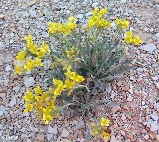
This site was visited in 2007 during the Rio Blanco County Inventory. Hay Gulch is a large draw southwest of Meeker, on the south side of the White River. Here the Parachute Creek member of the Green River Formation (oil shale, marlstone and siltstone) is exposed. This geologic formation includes the Mahogany ledge, one of the richest oil-shale zones in the basin, as well as potentially valuable deposits of nahcolite and dawsonite. The Parachute Creek substrate supports a good (B-ranked ) occurrence of the Colorado endemic Piceance Twinpod (Physaria obcordata), a plant that is critically imperiled globally (G1G2/S1S2) and that is Federally listed as Threatened. The site also includes a good (B-ranked) occurrence of a bluebunch wheatgrass (Pseudoroegneria spicata) grassland community, considered globally imperiled (G2/S2?).

This site was visited in 2007 during the Rio Blanco County Inventory. Hay Gulch is a large draw southwest of Meeker, on the south side of the White River. Here the Parachute Creek member of the Green River Formation (oil shale, marlstone and siltstone) is exposed. This geologic formation includes the Mahogany ledge, one of the richest oil-shale zones in the basin, as well as potentially valuable deposits of nahcolite and dawsonite. The Parachute Creek substrate supports a good (B-ranked ) occurrence of the Colorado endemic Piceance Twinpod (Physaria obcordata), a plant that is critically imperiled globally (G1G2/S1S2) and that is Federally listed as Threatened. The site also includes a good (B-ranked) occurrence of a bluebunch wheatgrass (Pseudoroegneria spicata) grassland community, considered globally imperiled (G2/S2?).

Piceance Twinpod (Physaria obcordata)
Tuesday, January 19, 2010
Biodiversity Scorecard - measuring effective conservation for Colorado species
Conservationists and planners need methods to identify priority areas for conservation, information on how to characterize the relative importance, quality, and urgency of these areas, and a means to measure conservation success on a regional or statewide basis over time. In order to assist the Colorado office of The Nature Conservancy with their "Measures of Success" program, and to provide biodiversity status information to other organizations in Colorado, the Colorado Natural Heritage Program has developed a prototype analysis of the status of Colorado's biodiversity, using a "scorecard" approach.
There are over 2,500 native plant species within Colorado. CNHP tracks over 500 of the rarest of these plants. The 103 most at-risk of these species for which we have sufficient data were included in this initial biodiversity scorecard. Likewise, out of the 500 native vertebrate animal species in Colorado, we evaluated 113 of the most at-risk species (our knowledge of the rarest invertebrates is still sadly lacking).
At-risk status does not translate directly into federal legal protection. Of all the at-risk species in our state, a much smaller number are listed as threatened or endangered under the Endangered Species Act:

Plants, animals, and ecological systems can only be considered effectively conserved when their biodiversity status is viable, threats have been abated, and land management/protection is sufficient to ensure the long-term persistence of the element. For more information about how we calculated these scores and which species we evaluated, see our draft Biodiversity Scorecard.
There are over 2,500 native plant species within Colorado. CNHP tracks over 500 of the rarest of these plants. The 103 most at-risk of these species for which we have sufficient data were included in this initial biodiversity scorecard. Likewise, out of the 500 native vertebrate animal species in Colorado, we evaluated 113 of the most at-risk species (our knowledge of the rarest invertebrates is still sadly lacking).
At-risk status does not translate directly into federal legal protection. Of all the at-risk species in our state, a much smaller number are listed as threatened or endangered under the Endangered Species Act:
- Amphibians = 0
- Birds = 5
- Fish = 5
- Mammals = 5
- Reptiles = 0
- Plants = 13

Level of effective conservation for Colorado species of concern
Plants, animals, and ecological systems can only be considered effectively conserved when their biodiversity status is viable, threats have been abated, and land management/protection is sufficient to ensure the long-term persistence of the element. For more information about how we calculated these scores and which species we evaluated, see our draft Biodiversity Scorecard.
Thursday, January 14, 2010
Natural Heritage Methodology Training at CNHP in March
The Colorado Natural Heritage Program will be hosting Natural Heritage Methodology Training (NHMT) at Colorado State University March 2-5, 2010. NHMT provides employees of NatureServe member programs (and partner organizations that work closely with natural heritage data) the opportunity to learn the fundamentals of all aspects of natural heritage methodology—from data collection to data management and data use. It also provides a foundation for understanding the different roles and functions of natural heritage programs.
The curriculum will include:
All three sites will be connected via online meeting services, including audio and video. Portions of each day will be "live" in each site.
For more information and to register for the training, please visit: http://www.natureserve.org/visitLocal/nhmtraining.jsp
Update: It looks like registration is full for the Fort Collins location, but as of 02/04 there are still a few spaces at the Virginia and Massachusetts locations.
The curriculum will include:
- Day 1: Element Methodology (species and ecological data)
- Day 2: Data Collection and Element Occurrence Methodology (includes introduction to Biotics)
- Day 3: Viability and Integrity (Element Occurrence Ranking) Methodology; Data Sensitivity and Data Applications; field trip
- Day 4: In-depth topics in Ecology, Botany, Zoology, and Data Management; Element Distribution Modeling; Conservation Planning
All three sites will be connected via online meeting services, including audio and video. Portions of each day will be "live" in each site.
For more information and to register for the training, please visit: http://www.natureserve.org/visitLocal/nhmtraining.jsp
Update: It looks like registration is full for the Fort Collins location, but as of 02/04 there are still a few spaces at the Virginia and Massachusetts locations.
Tuesday, January 12, 2010
East Fork Park PCA receives conservation easement protection
Back in 1998, CNHP Ecologist Renée Rondeau led the Biological Survey of Mineral County, and one of the resulting Potential Conservation Areas (PCA) was the East Fork Park. This PCA contains both wetland and upland features that make it import to the biodiversity of the area. In particular, Renée noted that East Fork Park supports one of the healthiest riparian areas in Mineral County.

Now, more than a decade later, we are very pleased to see, from the Durango Herald News, that East Fork Park has been protected through a conservation easement. Renée and our Director, Dave Anderson, had written a letter of support for this proposed conservation easement project last year at the request of the parties involved.
Our congratulations go out to the Southwest Land Alliance and the McCarthy family for completing this conservation easement. We are delighted to be reminded that CNHP's inventories are important testimonies to conservation actions.

Douglas fir old growth at East Fork Park PCA (photo by Renée Rondeau)
Now, more than a decade later, we are very pleased to see, from the Durango Herald News, that East Fork Park has been protected through a conservation easement. Renée and our Director, Dave Anderson, had written a letter of support for this proposed conservation easement project last year at the request of the parties involved.
Our congratulations go out to the Southwest Land Alliance and the McCarthy family for completing this conservation easement. We are delighted to be reminded that CNHP's inventories are important testimonies to conservation actions.
Thursday, January 7, 2010
Triploid Colorado Checkered Whiptail

The triploid Colorado checkered whiptail (Aspidoscelis neotesselata), a small lizard with a big name.
CNHP zoologist John Sovell took these photos in southeastern Colorado, which is home to a rare species of checkered whiptail lizard. Described as a separate species in 1997, CNHP tracks this unusual lizard under the name Aspidoscelis neotesselata. This population of triploid (having three sets of chromosomes instead of the usual two) animals is entirely made up of females, who are able to reproduce parthenogenetically. In parthenogenetic species, reproduction is asexual, and egg cells develop without having been fertilized by male gametes. Consequently, offspring are genetically identical with their mother.

This checkered whiptail is keeping a close eye on John.
Aspidoscelis neotesselata is found in juniper and pinyon-juniper woodland, arid, rocky canyons, rocky hillsides, shrubby areas, and open savannahs around the Arkansas, Huerfano, Apishapa, and Purgatoire rivers and their tributaries.

In this photo, you can see where the "whiptail" part of the name comes from.
Tuesday, January 5, 2010
Field techniques - Percent cover part 2, the microplot
Although visual estimation of percent cover is quick and inexpensive, we also make use of more accurate and intensive methods for estimating percent cover, especially during monitoring projects. Here is CNHP ecologist Renée Rondeau using a point-frame to read a microplot on the shortgrass prairie.

The wooden frame is divided by wires into a grid with 50 points, each 5 cm apart. A similar grid could also contain 100 points, with each point representing a percent - the key feature is that the observer must be able to look directly down on every single point to identify what lies below. In this potential mountain plover habitat, Renée is estimating the percentage of bare ground and litter by counting the number of points with bare soil, biotic soil crusts, pebbles, cowpies, or downed dead vegetation (including stump remains of grasses) directly beneath.
With a large enough sample of microplots, we can begin to determine whether the area is suitable for the plovers. Obviously this technique can be time-consuming, so we try to rope in additional field assistants whenever we can:


Make sure not to count your feet!
The wooden frame is divided by wires into a grid with 50 points, each 5 cm apart. A similar grid could also contain 100 points, with each point representing a percent - the key feature is that the observer must be able to look directly down on every single point to identify what lies below. In this potential mountain plover habitat, Renée is estimating the percentage of bare ground and litter by counting the number of points with bare soil, biotic soil crusts, pebbles, cowpies, or downed dead vegetation (including stump remains of grasses) directly beneath.
With a large enough sample of microplots, we can begin to determine whether the area is suitable for the plovers. Obviously this technique can be time-consuming, so we try to rope in additional field assistants whenever we can:

clop...clop...clop...Three percent? Got it.
Subscribe to:
Posts (Atom)
