Showing posts with label Collaborations. Show all posts

Wednesday, August 30, 2017

Conservation Easement Study

CNHP is pleased to share the study, "Colorado’s Return on Investments in Conservation Easements: Conservation Easement Tax Credit Program and Great Outdoors Colorado." This study evaluates public benefits received by Coloradans from state investments in conservation easements. The study found that each dollar invested by the state produced benefits of between $4 and $12 for Coloradans in addition to protecting numerous key conservation priorities. To learn more, please see the CSU press release linked below.

https://source.colostate.edu/investments-conservation-easements-reap-benefits-colorado/

It was fantastic to work with our colleagues in the Warner College of Natural Resources and @CSUCollegeAgriculturalSciences. This report would never have been possible without help from Great Outdoors Colorado - GOCO, the land trust community and a generous private donation to help fund our work. Thanks to everyone who made this important work possible and we hope the study provides useful information on the State's return on investment for private land conservation efforts.

Pleasant Valley near Bellvue, Colorado

Wednesday, July 19, 2017

Rifle and Carbondale Bioblitzes

By Riley Reed

What is a bioblitz?
Last week as a CNHP intern I had the opportunity to participate in two bioblitzes in Rifle and Carbondale, Colorado! A bioblitz is when a team of scientists travels to a designated area to best identify all the flora and fauna species. The scientists are given a twenty four hour period to find, identify, and document all the species that they can. Pictures or live samples are taken of each species that is documented. The purpose of the bioblitz is to gather information about the biodiversity of the area. This can help landowners manage their property more efficiently and promotes the best land use practices. It can also bring attention to any threatened and endangered species that are on the property.

First time? Won't be your last!
For many of the interns and volunteers, including myself, it was our first time learning about and helping with a bioblitz. It was a great learning opportunity that allowed us to get hands-on experience in a relaxed and fun manner. Many different fields of natural resources' work were covered, such as zoology, botany, restoration ecology, and human dimensions. All of the CNHP scientists were very helpful and passionate about spreading their knowledge and teaching the interns and volunteers.

Where did we go?
A large group from CNHP consisting of zoologists, botanists, interns, and volunteers left Fort Collins and headed west to the bioblitz location on a ranch in Rifle. The Ranch had a wide range of habitats that provided a high biodiversity rate relative to the size of the property. The data that was collected on the property was achieved through a variety of different methods. Birds and other wildlife were spotted during flash surveys of the property; camera traps were also set up at various locations. Bats were documented using a sonogram that was set up near the pond at night. Insects were captured with insect nets and a UV light trap at night. Fish were documented with the help of Colorado Parks and Wildlife and one of their fish shocking experts. (I would like to note that no fish were hurt during the fish shocking studies.) Trees, forbs, and grasses were identified and keyed out by the botany teams by walking the property. One specialist group of individuals from the botany team focused their entire time searching and identifying mosses and lichens. Once all of the species were identified to the best of our ability, we packed up and headed to our next location 45 minutes from Rifle around Carbondale.

Change it up?
The Ranch in Carbondale offered a good change of scenery and a new challenge to identify all the species on this section of land. Methods that were used in Rifle were repeated with slight modification to suit the new landscape. The zoologist team had wonderful success catching and identifying a wide variety of new butterflies, and the botany team had great achievements monitoring a rare species of plant known as good-neighbor bladderpod.

Overall, this was a life changing event, and I look forward to participating in future bioblitzes.

Friday, May 13, 2016

Snaketail Ale Brewed for Virginia Natural Heritage Program's 30th Anniversary

You might remember that a few years back CNHP developed a novel collaboration with Odell Brewing Company to conserve the hops blue butterfly (Celastrina humulus). The hops blue butterfly is a rare butterfly in Colorado whose host plant is wild hops (Humulus lupulus). The fruition of that collaboration was Celastrina Saison (pictured below), which produced a $1/bottle donation from Odell Brewing Company to fund studies of the hops blue butterfly.
  Our friend Jason Bulluck at the Virginia Natural Heritage Program (VNHP) liked the idea of partnering with breweries for conservation, and took the idea for Snaketail Ale to Triple Crossing Brewing Company in Richmond, VA, and they loved it! This beer celebrates the St. Croix snaketail, a rare dragonfly known from the Richmond area, and commemorates the VNHP’s 30th anniversary. Snaketail Ale is a heavily dry-hopped session ale that can be found on tap at Triple Crossing Brewery, Richmond, Virginia. Cold 32oz “crowler” cans of Snaketail Ale can be purchased at the brewery's tasting room. Raise a glass and toast to conservation!

Monday, March 23, 2015

CNHP Director Attends Plant Conservation Alliance Meeting in Washington, D.C.

CNHP director David Anderson recently attended meetings in Washington, D.C. organized by the Plant Conservation Alliance (PCA). The PCA is a public-private-agency partnership of organizations that work to maintain, enhance, and restore native plant populations and communities. Anderson worked with other non-federal cooperators during the meeting to identify strategies for plant conservation. He presented information on the addition of rare plants to the Colorado State Wildlife Action Plan (SWAP), as well as the Rare Plant Conservation Initiative project that helped prompt this exciting addition to the Colorado SWAP. Crafting a bill to create a National Plant Conservation program was the primary strategy identified by the group. Anderson, along with other PCA members, also met with members of the appropriations committees and federal agency leaders to discuss plant conservation, including the National Seed Strategy. After the Strategic Planning Meeting, Anderson was able to participate in a tasting of botanical spirits hosted by the United States Botanical Garden and led by Dwight Grimm. Grimm is a vermoutheir and founder of the Little Alchemist Farm. He produces small-batch herbal spirits, elixirs, and oils from his farm in Preston Hollow, New York.

CNHP director Dave Anderson (far right) with other participants in the Non-Federal Cooperators Committee Strategic Planning Meeting.

Tuesday, July 15, 2014

CNHP Director's Adventures in India - Part 1

Dave about to depart to India!
CNHP’s Director Dave Anderson has departed for India, where he’ll spend the next six weeks working in an exchange of conservation practices with the faculty of the Wildlife Institute of India (WII).  He is doing this with support as a Fulbright Specialist.  The WII Director, Dr. Vinod Mathur, and Dave have spent the last three years working to make this happen, and it is finally going forward!  The scope of work for this partnership includes doing fieldwork on sites in the Western Himalayas with another faculty member of the WII, Dr. Ishwari Rai, to document rare plants and other conservation targets, and assess their Key Ecological Attributes, threats, and viability.  They will then use this information to support the development of a Conservation Action Plan.  Four Open Standards Coaches are coming to the WII to lead this workshop - Terri Schulz from the Colorado Field Office of TNC, and Lucy Boddam-Whetam, Adam Barlow, and Christina Greenwood Barlow from a UK-based non-profit called WildTeam.  Dave will also be giving lectures and meeting with the Faculty to share the methods used by CNHP and the NatureServe Network of Heritage Programs.  Stay tuned for updates on Dave’s adventure!

Monday, March 3, 2014

Adapting to Climate Change by Restoring Wetlands

Climate change presents challenges and opportunities for conservation and livelihoods throughout Colorado and rather than standing by and doing nothing we present an example of a restoration strategy that benefits birds, wetlands, groundwater, ranching, and overall health of the landscape while planning for future climate change.  As temperatures rise and precipitation variation becomes even greater than today we can expect frequency and intensity of droughts to increase thus threatening our wetlands that are so important to life.  Restoring our valuable wetlands today will create resilience to a changing climate and help people and nature adapt to the future.

Through a public-private partnership in the Gunnison Basin (initiated by The Nature Conservancy) we completed a two-year pilot project of restoring wet meadow habitats within sagebrush shrublands.  Using simple and non-expensive techniques that utilize local material we raised the water table and reduced erosion by eliminating headcuts.  In less than two years we can already see the benefit of these simple structures.

Thanks go to the Gunnison Climate Working group, Upper Gunnison River Water Conservancy District, Wildlife Conservation Society, Colorado Parks and Wildlife, Rocky Mountain Bird Observatory, US Fish and Wildlife ServiceSouthern Rockies Landscape Conserrvation Cooperative and private donors,  Bureau of Land Management, U.S. Forest Service, Natural Resources Conservation Service, Colorado Natural Heritage Program, Western State College, Zeedyk Ecological Consulting, and The Nature Conservancy.

The following presentation was created by Strijek Design with assistance from the Colorado Natural Heritage Program.

Click to view a fullscreen presentation 

One can also view a short video of this project here.

Tuesday, October 29, 2013

CNHP director featured in Larimer County video

CNHP director David Anderson makes an appearance in a video about how Great Outdoors Colorado support for our work and that of our partners has helped to transform the face of Colorado in wonderful ways. Watch “Leveraging Colorado Lottery Funds” here:


Monday, October 7, 2013

Natural Resource Management Decision-Making under Climate Uncertainty: Building Social-Ecological Resilience in Southwestern Colorado

In joint collaboration with several other institutes, the Colorado Natural Heritage Program was awarded a multi-year project from the North Central Climate Science Center (part of U.S. Geological Survey): “Natural Resource Management Decision-Making under Climate Uncertainty: Building Social-Ecological Resilience in Southwestern Colorado.”  RenĂ©e Rondeau, Ecologist and Conservation Planner with the Colorado Natural Heritage Program is the CSU Principal Investigator and will be working closely with Jeffrey Morrisette and Dennis Ojima (North Central Climate Science Center), as well as University of Montana, The Nature Conservancy, Mountain Studies Institute and USGS-Fort Collins over the next few years to facilitate climate change adaptation that contributes to social-ecological resilience, ecosystem/species conservation, and sustainable human communities in Southwestern Colorado while focusing on the Gunnison Basin and the San Juan Mountains.  

Gunnison Basin landscape with East Beckwith Mountain in the background.
The group will develop a set of actionable and prioritized social/ecological adaptation strategies for vulnerable ecosystems and species based on best available science.  These adaptation strategies will incorporate the latest in climate science and must be useful and meaningful to natural resource managers and other stakeholders.  The Gunnison and San Juan Basins ownership and economies revolve around ranches and private industry that relies on natural resources, US Forest Service, US National Parks, Bureau of Land Management, and Tribal Lands, and will be integral in the success of this project.  The frameworks that are developed for this project should be applicable to other western landscapes and will help guide communities in adapting to changes associated with a changing climate.  

Wednesday, May 8, 2013

CNHP visits Odell Brewery for a behind-the-scenes look at Celastrina Saison

by Rob Schorr, CNHP Zoologist

Karla Baise of Odell Brewing (left) with the CNHP group as we all toast
our Celastrina Saison samples to the rare hops blue butterfly

As Celastrina Saison gets closer to its release date (May 18th Tapping Party at Odell Brewery), CNHP and Odell have made more opportunities to interact.  Namely, Odell Brewery gave CNHP the opportunity to come backstage at the brewery for a tour of the facilities and to witness the brewing process.  We eagerly took the invitation as a dozen of CNHP and Warner College of Natural Resource personnel met Karla Baise, Odell Brewery’s Community Outreach Coordinator in Odell’s Tasting Room.  Karla led us through the Odell facility, showing off a beautiful assembly of brewing tanks and Odell’s new 12-pack bottling system.  As we stood admiring the large brewing tanks, one of the brewers tapped the tank holding Celastrina Saison and gave us our first taste; as tasty as the bottle is beautiful.  Around one turn I stopped in my tracks as I saw the image of the hops blue butterfly on stacks of boxes just waiting to be filled with Celastrina Saison, destined for the 10 states that carry Odell brews.

Rob Schorr with the boxes waiting to be filled with Celastrina Saison

What became apparent during the tour is that Odell loves this partnership as much as we at CNHP do.  During the tour, Karla brought out a small bar-style poster of Celastrina Saison, which will be framed in the halls here at CNHP.  Right on the label it tells the world about the butterfly, this collaboration, and CNHP.  Thank you, Odell Brewing Company.

Celastrina Saison poster

Monday, April 29, 2013

Expanded National Natural Landmark

Earlier this month, then Secretary of the Interior Ken Salazar approved the expansion of the Garden Park Fossil Area National Natural Landmark on BLM land near Cañon City. CNHP provided the National Park Service with the evaluation of this site for the expansion. Read the BLM press release here.

Looking across Fourmile Creek to the Marsh quarry site.

The Garden Park Fossil Area is located in Fremont County, Colorado, along the Fourmile Creek drainage approximately 8 miles north of Cañon City. The site was originally designated in 1973 in recognition of the historical and paleontological significance of the Jurassic age dinosaur discoveries excavated from outcrops of the Morrison Formation in the area. The original designation included the Colorado Historical Society monument located on the roadside below the Marsh Quarry, but did not cover the important fossil quarries.

Quarries in the Garden Park area played an important role in the “Bone Wars” of the early period of American paleontology, and activities at this site were responsible for generating wide-spread interest in dinosaurs beginning in the late 1870s. Important discoveries include the three most complete Stegosaurus skeletons ever found, as well as the first known remains of dinosaurs like Camarasaurus, Ceratosaurus, and Diplodocus. In addition to dinosaurs, Garden Park has also produced fossils of Late Jurassic mammals, trees, and turtles, among other things, and finds include 23 type specimens.

Brandegee's buckwheat (photo by Susan Spackman-Panjabi).

The site also supports populations of three of Colorado's rare plants: Eriogonum brandegeei (Brandegee’s buckwheat) Mentzelia chrysantha (golden blazing star), and Asclepias uncialis (dwarf milkweed).

Monday, April 15, 2013

Creative Collaborations: How CNHP and Odell Brewing Company are working together to save the hops blue butterfly


by Rob Schorr, CNHP Zoologist

While conducting a biological inventory at the U.S. Air Force Academy in Colorado Springs, Jeremy Siemers and I were lucky enough to stumble upon a few hops blue butterfly (Celastrina humulus; a G2/G3 invertebrate) populations.  This butterfly is found in a handful of counties in Colorado and gets its name from its host plant, wild hops (Humulus lupulus).  We started a lively discussion about how best to monitor such a butterfly, or even how to assess the prevalence of the butterfly on its host plant.  We tossed ideas around, beat up some study designs, and finally came up with a research plan we thought was feasible.  Unfortunately, it was unfunded.  These discussions led to hops-and-barley fueled brainstorming on how to fund such a study…the natural connection was right in our hands.

Female hops blue butterfly on wild hops
After some courting and scheduling, I was able to visit Fort Collins' own Odell Brewing Company and talk with them about CNHP, the hops blue butterfly, and a creative collaboration of beer and butterfly conservation.  The talk was warmly received and Odell eagerly agreed to develop a beer to commemorate this minute Colorado endemic.  This novel partnership has led to the recent announcement that Odell Brewing Company will be releasing Celastrina Saison in a Belgian farmhouse 750-ml bottle in late May 2013.  The label boldly shows a male hops blue butterfly and along the edge of the label is a description of how $1 of each 750 ml bottle will go toward CNHP for hops blue butterfly research. This partnership between Odell Brewing Company and CNHP developed out of a shared interest in conserving species and landscapes that are uniquely Colorado.

Rob holding a Celastrina Saison
Please look for Celastrina Saison on the shelves of your favorite liquor store, at your favorite pub, or at the Odell Brewing Company tap room…and raise a pint for butterfly conservation!

Tuesday, February 26, 2013

Mapping warm water sloughs on the South Platte

by Jeremy Sueltenfuss, CNHP Wetland Ecologist


For many years, our partners in the wildlife community have talked at length about the importance of warm water sloughs for overwintering Colorado wildlife.  As they are continually recharged by emerging groundwater, which is not subjected to the freezing temperatures at the surface, these stream-like features are some of the only water bodies across the landscape that remain open throughout the winter, providing wildlife much needed access to water during the cold winter months.  Because of their importance, we set out to map all the sloughs we could find along the South Platte River.  While aerial imagery can be quite good at mapping water features, nothing beats a low altitude flight to get a sense of the landscape!

Though familiar with the more common method of flying (being inside the plane that is), Jacqui thought she would give this method a shot.  It did not last long.  An immense thanks to Colorado Parks and Wildlife for supplying us with their plane and the CPW pilot, Brian, for a very safe and rewarding experience.  
Taking off in a small four seat prop plane from the Fort Collins – Loveland airport (Fort Love as our pilot referred to it), Jacqui, a fearless CNHP work-study student and I put our faith in our pilot, Brian.  Brian has been flying for Colorado Parksand Wildlife (CPW) for years, and his knowledge of both the landscape and local wildlife was tremendously beneficial.  Beyond his ability to spot herds of deer, gaggles of geese, and flocks of turkey from amazing distances, his stories from his work for CPW were breathtaking.  While I love hiking to remote mountain lakes, I have never thought about what it takes to stock them with fish.  Brian’s stories of maneuvering his small plane through tight mountain corridors, dropping his air speed to levels I personally never wish to feel while in flight, and releasing hundreds of small fish at precisely the right moment for them to land in the lake, all while watching the rock face in front of you fill your vision, was enough to make me sweat.  Luckily for us, the only aerial acrobatics we performed were slow broad circles to get a closer look at a slough, or a better view of some wildlife. 

Continually being recharged by groundwater, warm water sloughs remain slightly warmer than other surface waters and remain open throughout the winter.  This provides much needed access to water for wildlife in the area.
Though “Colorful Colorado” is quite brown in the winter, flying at 150 feet over the South Platte was fascinating and beautiful.  As promised, sloughs seemed to be the only open water around, and the leafless trees afforded views of the many flocks of waterbirds, small herds of deer bounding away, and even a few scenes of male turkeys doing their best to impress a nearby female.  The seven bald eagles we saw perched in trees or soaring above the river provided a wonderful example of an Endangered Species Act success story and served as tribute to the tremendous effort of conservation groups over the past 50 years.  It was enough to almost forget what we were after!  Armed with maps of sloughs we had completed before the flight using imagery from the summer, we constantly compared what was in our maps to what we were seeing on the ground.  Both Jacqui and Brian seemed to do quite well looking down at maps and back out at the landscape for 4 straight hours.  While I did my best to appear absolutely normal, my stomach was reenacting what it must feel like to stock those high mountain lakes!  Queasiness aside, we accomplished our goal and came away with a highly accurate map of the warm water sloughs along the South Platte River between Greeley and the state line.  Though many other riparian landscapes across the state contain warm water sloughs that may one day be mapped, I have high hopes this data can be used for the restoration and the conservation of lands containing these important features.     

Thursday, February 7, 2013

New Report: Treeline Monitoring in the San Juan Basin Tundra


Mountain ecosystems, particularly alpine, are among the most vulnerable to climate change. Warming conditions are likely to cause trees and shrubs to encroach into alpine tundra habitats, which are home to many species found nowhere else.

CHNP, in cooperation with the Bureau of Land Management, U.S. Forest Service and Colorado College, began a pilot project to monitor treeline expansion in the San Juan mountains. A combination of fieldwork and spatial analysis was used to determine if the treeline on the southwest slope of Kendall Mountain had changed in the last 50 years.

Aerial imagery from 1951 and 2011 were used to establish transects perpendicular to the treeline to detect growth of new trees upslope, which would indicate an upward advancement of trees into alpine areas. The location of trees along these transects were then field verified, and a subset of trees were cored to determine their age. Additionally, the density of trees below the treeline was calculated for both time periods.

Recruitment above treeline
Results show that the treeline has not advanced significantly in the last 50 years. However, there are signs of upslope recruitment (trees between 20-50 years old above the current treeline, but not in sufficient density to form a new treeline). Should this area of new recruitment continue to fill in and become the new treeline, it will be 160 feet above the existing line. Additionally, tree density below the current treeline has increased by approximately 12% in the last 50 years. All tree cores taken demonstrated an increase in growth rate since 1996.

For more information, see the complete report. We hope to expand this pilot project to study more treelines throughout the San Juan mountains, to determine if these increases in growth rate and tree density are consistent trends that can be correlated with measured increases in average summer temperatures.

Friday, January 4, 2013

The State of Colorado’s Biodiversity


For the first time in Colorado, scientists and land managers have access to a comprehensive report that measures conservation progress during the past 40+ years. The Nature Conservancy and the Colorado Natural Heritage Program at Colorado State University recently released a report on the state State of Colorado’s biodiversity which ranks the state’s natural heritage as “in relatively good condition” or “restorable.” The report identifies progress on many plant and animal species but notes that significant challenges remain.

The report documents a “scorecard” evaluation using the best available collective data to evaluate lands, animals and plants under the three broad categories of rarity,threats, and protection.

Key findings include:
  • Colorado’s major habitat types are all important for at-risk species and are relatively intact with at least 70% scoring good or very good based on size, condition, and the surrounding conditions.
  • About 40% of all fish and amphibians are inadequately conserved, an indicator of the condition of Colorado’s streams, rivers, and wetlands.
  • Colorado’s prairies are the most highly altered and least protected natural systems and support the most at-risk animals.
  • Many of Colorado's rarest plants are effectively conserved; others are at risk in the path of energy and urban development
  • Lower elevation forests (especially pinyon-juniper and ponderosa pine) are in the poorest condition, are significantly under-conserved and present a high risk of severe fire.
The Nature Conservancy developed the concept, made final reviews and provided funding. The Colorado Natural Heritage Program provided project guidance and conducted the research. The findings create a formal benchmark for gauging the degree to which Colorado’s natural diversity has remained intact for our children.

To read the complete report, click here.

Early reviews from our partners have been favorable:

“The type of information this report contains has been invaluable to the Gates Family Foundation. We have been investors in conservation in Colorado for decades. But until recently, it has been hard to find data that allows the conservation community to keep score in any comprehensive fashion. This data has played a central role in our decision to increase our investment in conservation of Colorado’s grasslands and management and protection of Colorado rivers and streams.”
--Tom Gougeon
President, Gates Family Foundation

“This report tells us we’re doing a good job of conserving birds thanks to private and public land managers. Through cooperative partnerships we can keep moving the conservation needle forward so Coloradoans and people throughout the West enjoy beautiful birds for generations to come.”
--Tammy VerCauteren
Executive Director, Rocky Mountain Bird Observatory.

Thursday, October 18, 2012

Mapping Eutrema penlandii

by Bernadette Kuhn, CNHP Botanist

A few months ago, CNHP joined forces with botanists from the U.S. Fish and Wildlife Service and the Mosquito Range Natural Heritage Initiative to survey for rare plant in the Leadville area. The conditions were perfect. Despite a few threatening clouds, we had a bluebird survey day. After four hours of crawling through the alpine, we found what we were looking for. The tiny plant, Eutrema penlandii, is a member of the mustard family (Brassicaceae). Listed as Threatened under the Endangered Species Act, it is found primarily in wetlands and alpine fens above treeline.

Volunteer Merit Glenne at the new Eutrema penlandii site near Mt. Arkansas, outside Leadville, Colorado.

Very few populations of E. penlandii have been mapped on the west side of the Continental Divide. Our findings suggest more surveys on this side of the Divide may result in a range expansion for this narrowly distributed Colorado endemic.

Neil Peterson, Mosquito Range Natural Heritage Initiative, flags Eutrema penlandii individuals.

Eutrema penlandii in fruit.

Tuesday, October 2, 2012

Volunteers needed for Gunnison Climate Adaptation Project

Join The Nature Conservancy, the Gunnison Climate Working Group, and other partners for the Gunnison Climate Adaptation Project Volunteer Days on Oct 13-14. Contact Betsy Neely (720-974-7015 or bneely@tnc.org) with questions.

Tuesday, September 25, 2012

CNHP director stars in Mt. Evans video

Back in July, CNHP director Dave Anderson, ecologist Denise Culver, and botanist Jill Handwerk visited the Summit Lake Park to help Denver Mountain Parks and the Colorado Native Plant Society document the vegetation in the area. While they were there, Colinda DeGroen, videographer and CEO of RangeTracker made a video narrated by Dave, featuring some of the interesting plants around Summit Lake.


Great job Dave - we'll look for you on the red carpet at the next Academy awards! Best performance under conditions of high wind and attack marmots?

Thursday, September 20, 2012

Ecosystems in the High Park fire area

The most common ecosystems in the High Park and Hewlett fire area are lower montane-foothill shrubland, ponderosa pine woodland, mixed conifer forest, and lodgepole pine forest.

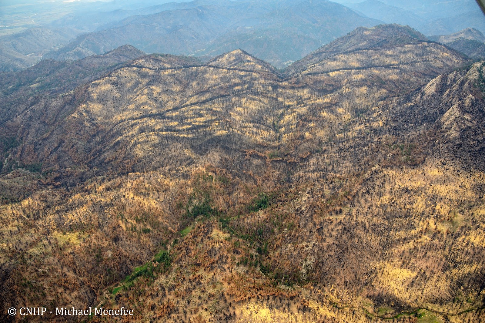
Many square miles of these shrubland, woodland, and forest ecosystems were burned during the May and June fires. In August, LightHawk volunteer pilot Dan Evans flew CNHP’s Michael Menefee, Jill Handwerk, and Dave Anderson over the area. Although it was hazy, they were able to take many excellent photos of the burn effects. 

The view down the Poudre Canyon (at right) at its junction with Cedar Gulch (left). Slopes are mostly foothills shrubland dominated by mountain mahogany. Burned stands of mixed conifer are on north-facing slopes.

Closer view of burned mountain mahogany (gray circles) against a background of green grass and forbs. It doesn't look too bad from up here. The shrubs will resprout after being burned.

Burn mosaic of ponderosa pine and mixed conifer in the Bear Mountain area, south of the Cache la Poudre River. View is to the north toward the Narrows and Sheep Mountain beyond.

Fire edge at Pingree Road. Burned ponderosa woodland to the left, unburned woodland to the right.

Ponderosa burn mosaic at Buckhorn Mountain.

Fire boundary at Buckhorn Road. Burned lodgepole to the right, unburned to the left. There are many beetle-killed trees still standing in the unburned area.

Lodgepole burn mosaic, vicinity of West White Pine Mountain.

A closer view of burned lodgepole forest.

Jill, Michael, and Dave back on the ground after the flight.

Many thanks to Dan and LightHawk. Stay tuned for more High Park fire photos.

Thursday, September 13, 2012

Erosion in the High Park fire area


If you drive up Highway 14 through the Poudre Canyon this fall, you might not really notice the extent of the Hewlett and High Park fires. Some hillsides are black, but many others have green and living trees around the killed and burned areas. In the ten weeks since the fire was contained, occasional heavy rains have promoted the growth of grasses and other herbaceous plants, so that many burned areas now have a new carpet of green. Unfortunately, another effect of the heavy rains that followed the burn is severe erosion. The remains of debris flows crossing the highway are evident in numerous places.


In August, LightHawk volunteer pilot Dan Evans flew CNHP’s Jill Handwerk, Michael Menefee, and Dave Anderson over the burn area, where they took many dramatic photos of the fire’s aftermath.


The hills west of Seaman Reservoir are yellow with recently dropped straw,
 intended to minimize erosion into our drinking-water supply.

The burned slope in the lower left (east of Stove Prairie Landing) has sent substantial debris flows into the Cache la Poudre below.

Debris fans coming off Sheep Mountain are visible in the lower center of this photo, across the road from the Upper Narrows Campground. This area has greened up a lot since the fire jumped the highway here in June.

Erosion along the Old Flowers Road, west of Stove Prairie.

Gullies on the west side of West White Pine Mountain.

Thanks again to LightHawk and Dan for giving us a bird's-eye view of this major disturbance.
Stay tuned for more High Park fire photos.

Friday, September 7, 2012

Biodiversity in the High Park burn area


Between the Hewlett fire in May, and the High Park fire in June, nearly 95,000 acres of Larimer County felt the effects of wildland fire in 2012.  Thanks to LightHawk volunteer pilot Dan Evans, CNHP’s Dave Anderson, Jill Handwerk, and Michael Menefee were able to fly over the burn area and check out the impacts to some of the elements of biodiversity that CNHP has documented over the years.

The Larimer aletes (Aletes humilis) is endemic to the Colorado Front Range, where it thrives in the shallow, gravelly surface soils around rock outcrops, such as are found at Gray Rock in the Hewlett burn area.


Larimer aletes habitat at Gray Rock - some burned, and some escaped - we don't know about the plants themselves yet.

The Arapaho stonefly is known only from two tributaries to the Cache la Poudre River: Elkhorn Creek and Young Gulch (where it has not been seen since 1986).

Young Gulch on the left was in the burned area (Mishawaka is visible in the lower right).

Fortunately, Elk Creek (center, above) was just outside the burn area - a narrow escape for the little stonefly!

The High Park burn area is also home to a variety of plant communities that are typical of this part of the Colorado Front Range.

Slopes above the South Fork of the Poudre as it winds its way south of Mt. McConnel were once covered by a ponderosa pine savaana with grassy understory, or by dense stands of mixed conifer in wetter places.


On the south side of East and West White Pine Mountains, riparian areas of thinleaf alder and mesic graminoids are still largely green, while the surrounding lodgepole forest has burned black. The Buckhorn Road and edge of burn are visible in the lower right.

Thanks again to LightHawk and Dan!

Stay tuned for more photos from the High Park burn.