Showing posts with label Biodiversity Scorecard. Show all posts

Friday, January 4, 2013

The State of Colorado’s Biodiversity


For the first time in Colorado, scientists and land managers have access to a comprehensive report that measures conservation progress during the past 40+ years. The Nature Conservancy and the Colorado Natural Heritage Program at Colorado State University recently released a report on the state State of Colorado’s biodiversity which ranks the state’s natural heritage as “in relatively good condition” or “restorable.” The report identifies progress on many plant and animal species but notes that significant challenges remain.

The report documents a “scorecard” evaluation using the best available collective data to evaluate lands, animals and plants under the three broad categories of rarity,threats, and protection.

Key findings include:
  • Colorado’s major habitat types are all important for at-risk species and are relatively intact with at least 70% scoring good or very good based on size, condition, and the surrounding conditions.
  • About 40% of all fish and amphibians are inadequately conserved, an indicator of the condition of Colorado’s streams, rivers, and wetlands.
  • Colorado’s prairies are the most highly altered and least protected natural systems and support the most at-risk animals.
  • Many of Colorado's rarest plants are effectively conserved; others are at risk in the path of energy and urban development
  • Lower elevation forests (especially pinyon-juniper and ponderosa pine) are in the poorest condition, are significantly under-conserved and present a high risk of severe fire.
The Nature Conservancy developed the concept, made final reviews and provided funding. The Colorado Natural Heritage Program provided project guidance and conducted the research. The findings create a formal benchmark for gauging the degree to which Colorado’s natural diversity has remained intact for our children.

To read the complete report, click here.

Early reviews from our partners have been favorable:

“The type of information this report contains has been invaluable to the Gates Family Foundation. We have been investors in conservation in Colorado for decades. But until recently, it has been hard to find data that allows the conservation community to keep score in any comprehensive fashion. This data has played a central role in our decision to increase our investment in conservation of Colorado’s grasslands and management and protection of Colorado rivers and streams.”
--Tom Gougeon
President, Gates Family Foundation

“This report tells us we’re doing a good job of conserving birds thanks to private and public land managers. Through cooperative partnerships we can keep moving the conservation needle forward so Coloradoans and people throughout the West enjoy beautiful birds for generations to come.”
--Tammy VerCauteren
Executive Director, Rocky Mountain Bird Observatory.

Wednesday, January 2, 2013

NEW GEOSPATIAL DATASET ONLINE: Terrestrial Ecological System Patches


Terrestrial Ecological Systems are dynamic groupings of plant and/or animal communities that: 1) occur together on the landscape; and 2) are linked by similar ecological processes, underlying abiotic environmental factors, or gradients; and 3) form a readily identifiable unit on the ground (Comer et al. 2003). In order to assess the health of Colorado’s major ecosystems, CNHP developed a dataset of large-sized (>20,000 acres) ecological system patches for the “State of Colorado’s Biodiversity” project. Ecological systems were derived from the Southwest Regional Gap Analysis Project landcover dataset (USGS 2004).

Developing this dataset enabled CNHP to identify at-risk ecosystems in Colorado. Individual patches were ranked on a scale of 1-10 based on overall condition status, threat status and protection status. Top threats were assigned to each patch. The results of the analysis show that many of Colorado’s major ecosystems are intact, but only two are effectively conserved. Shortgrass prairie is by far the most altered ecological system. Nearly half of the shortgrass prairie in Colorado has been lost in the past century; however, several large, high quality areas still exist. While these data are an effective tool for broadly measuring current successes, they also highlight intact landscapes that pose great opportunities for future conservation efforts.


Table with Conservation Status Ranks of
Major Ecological Systems in Colorado
These data are bundled in an ESRI geodatabase and can be downloaded from CNHP’s website here.  As always, if you need more detailed information or need data for commercial use, please contact our Data Distribution Coordinator.

Thursday, April 5, 2012

Ecological Systems: Ponderosa Pine


Ponderosa pine woodlands are widespread throughout the western United States in warm, dry, exposed sites at certain elevations. In Colorado, ponderosa woodlands are primarily between about 6,000 and 9,000 feet, occurring at the lower treeline transition between grassland or shrubland and the more mesic coniferous forests above. These woodlands are especially prevalent along the mountain front, and on the southern flank of the San Juan Mountains.

Fire is the most significant ecological process in maintaining this system; frequent, low-intensity ground fires are typical. Healthy ponderosa pine forests often consist of open and park-like stands of mature trees, with an understory of predominantly fire-tolerant grasses and forbs. Older trees drop their lower branches as they age, which protects them from ground fires, usually only younger trees are killed. In stands where the natural fire regime is allowed to occur, shrubs, understory trees and downed logs are uncommon. A century of human development and fire suppression has resulted in a higher density of ponderosa pine trees in many areas. When fires are not allowed to burn, young trees continue to grow, and places that were once open savannas and woodlands become dense forests. The increased density of trees allows fires to reach the forest canopy, and these rapidly spreading fires can burn very large areas.

Flames in ponderosa woodland.

Ponderosa forests and woodlands provide habitat for a number of mammal species such as mule deer, mountain lion, porcupine, and Abert’s squirrel. Characteristic bird species include the pine siskin, mountain chickadee, pygmy nuthatch, and chipping sparrow. The most notable species of concern in Colorado's ponderosa pine ecological system is the federally threatened Pawnee montane skipper butterfly (Hesperia leonardus montana). This species occurs only in ponderosa pine systems with an understory of blue grama grass (the skipper’s host plant). In Colorado, Grace’s warbler is only known from ponderosa pine stands in southwestern Colorado, and the Mexican Spotted Owl is at the northern end of its range in south central Colorado.

Pawnee montane skipper.

Ponderosa woodlands cover some 3.2 million acres in Colorado. A little over half of this acreage is on public lands, however, most areas have no special protection. Many stands have been lost to urban development, and many of the remaining stands are in degraded condition. The likelihood of threats (primarily development and fire suppression) continuing into the future is high, and ponderosa pine is not well represented in our state's system of protected lands.
 
Overall biodiversity, threat, and protection status scores for ponderosa pine in Colorado.

A "windrose" graph depicting ponderosa status for individual scoring factors.


Wednesday, January 18, 2012

Ecological Systems: Southern Rocky Mountain Pinyon-Juniper


The Southern Rocky Mountain Pinyon-Juniper ecological system is similar to the Colorado Plateau Pinyon-Juniper system, but with a more restricted distribution in south central Colorado. In Colorado, the southern Rocky Mountain pinyon-juniper woodlands are found in the south central part of the state, around the San Luis Valley, southern mountain front east to Mesa de Maya, and north to the Arkansas River Valley and Palmer divide. Elevations range from about 5,000 to 9,000 feet. Pinyon-juniper also occurs in a limited distribution on the eastern plains near the Purgatoire River. These are open woodlands of warm, dry sites on mountain slopes, mesas, plateaus, and ridges. Pinyon pine and/or one-seed juniper dominate the tree layer, and Rocky Mountain juniper may be present at higher elevations. In the canyons and tablelands to the east, pinyon is absent, and this system is replaced by the Southern Rocky Mountain Juniper Woodland and Savanna system. Understory layers are variable and may be dominated by shrubs, grasses, sparse vegetation, or bare ground.

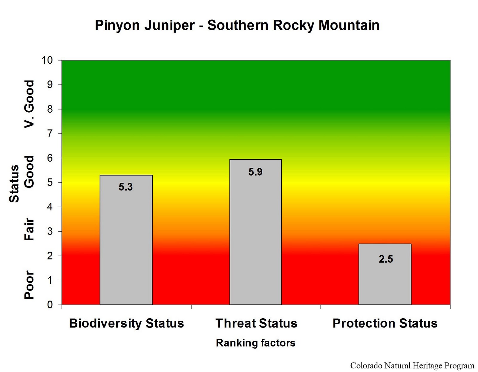
Southern Rocky Mountain pinyon-juniper covers some 1.25 million acres in Colorado. Ownership is divided about equally between private and public ownership, with the Bureau of Land Management responsible for the majority of federal holdings. Pinyon-juniper ecological systems have declined in both extent and quality compared to historic norms, although there are a number of very large patches remaining. Threats include urban development, recreation (especially motorized recreation), invasive species (most notably an increase in cheatgrass in the understory, which has led to increasing fire ignitions), and energy development.


Overall biodiversity, threat, and protection status scores for
Colorado Plateau Pinyon-Juniper in Colorado.
 
 
 A "windrose" graph depicting Colorado Plateau Pinyon-Juniper status for individual scoring factors.

Tuesday, January 3, 2012

Ecological Systems: Lodgepole Pine


In Colorado, the lodgepole pine ecological system is widespread between 8,000-10,000 feet in elevation, on gentle to steep slopes of the Rocky Mountains in the northern part of the state.  Stands may be pure lodgepole pine, or mixed with other conifer species. Following stand-replacing fires, lodgepole pine rapidly colonizes and develops into dense, even-aged stands (sometimes referred to as “dog hair” stands).  Lodgepole pine forests typically have shrub, grass, or barren understories, sometimes intermingled with aspen.  Shrub and groundcover layers are often sparse in lodgepole pine forests. Diversity of plant species is also low, perhaps as a result of the uniform age and dense canopy of many stands.
Lodgepole forests cover more than two million acres in Colorado. Although these forests are common across Colorado, most are experiencing widespread damage from a severe outbreak of mountain pine beetle. The pine beetle is a native species, and periodic outbreaks of this insect are part of the natural cycle that maintains our mountain forests.  Climate change, however, may enhance the scope and severity of the outbreaks. 
Lodgepole pine stands hit by the mountain pine beetle.
Common mammal species in these forests include the pine squirrel (also called chickaree), porcupine, mule deer, and elk. Typical birds are the Mountain Chickadee, Pine Siskin, Ruby-crowned Kinglet, and Yellow-rumped Warbler. Rarer species include the Three-toed Woodpecker and Williamson’s Sapsucker. These forests are used occasionally by lynx.
A porcupine contemplating the status of lodgepole forests.
Most of our lodgepole forests are on federally owned lands managed by the U.S. Forest Service, Bureau of Land Management, or National Park Service. Most are not completely within wilderness areas, although they may be present along the boundaries of these areas. Lodgepole pine forests in Colorado generally have good conservation status. Natural processes such as fire and pine beetle infestation are the most obvious impacts to these forests. Fire suppression and logging have affected some areas.
Overall biodiversity, threat, and protection status scores for lodgepole pine in Colorado.


 A "windrose" graph depicting lodgepole status for individual scoring factors.

Tuesday, November 29, 2011

Ecological Systems: Sagebrush Shrublands


There are two major types of sagebrush ecological systems in Colorado: big sagebrush shrublands and montane sagebrush steppe. These shrublands occur throughout much of the western United States. Although they can be found on Colorado’s east slope, the largest occurrences are on the western slope. North Park, Middle Park, and the upper Gunnison Basin have extensive stands of sagebrush shrublands.

     Big sagebrush shrublands in western Colorado.

Big sagebrush shrublands are typically found in broad basins between mountain ranges, on plains and foothills. Big sagebrush shrublands are characterized by a dense stands of taller sagebrush species with a significant herbaceous understory, and are generally found at elevations from 5,000 to 7,500 feet. Taller shrubs distinguish the big sagebrush shrubland ecological system from the montane sagebrush steppe shrublands, which are dominated by shorter sagebrush species.

Montane sagebrush, Gunnison County, Colorado.

Montane sagebrush steppe primarily occurs on ridges, near flat ridgetops, and mountain slopes. Montane sagebrush stands are usually found at elevations from 7,000 to 10,000 feet, often adjacent to the lower elevation big sagebrush shrublands.

Sagebrush shrublands provide food and shelter for many small mammal and bird species. The most significant at-risk animal species in Colorado’s sagebrush ecosystem is the Gunnison Sage Grouse, ranked “critically imperiled” (G1S1) by the Colorado Natural Heritage Program, and listed as a Tier 1 Species of Greatest Conservation need by the Colorado Division of Wildlife. Other Tier 1 Species of Greatest Conservation Need that are found exclusively (or almost exclusively) in sagebrush habitats are Greater Sage Grouse, Brewer’s Sparrow and Sage Sparrow. In addition, several of Colorado’s rarest plants are found primarily in sagebrush habitats. These include the federally listed (Endangered) Osterhout’s milkvetch, as well as several other globally rare members of the milkvetch family (Gunnison milkvetch, violet milkvetch, and skiff milkvetch). Other rare Colorado plants that are most commonly found in sagebrush habitats are the globally rare narrow-leaf evening primrose, Bessey locoweed, Fremont’s beardtongue, and Harrington’s beardtongue.

Many of Colorado’s sagebrush shrublands are vulnerable to changes induced by domestic livestock grazing. Over the past century the condition of much of Colorado’s sagebrush shrubland has been degraded due to fire suppression and heavy livestock grazing. Although many livestock operations are now more sensitive in their treatment of sagebrush habitats than they once were, recovery in these systems is slow. Furthermore, many remaining sagebrush patches are now being fragmented by fast-paced and widespread energy development.

Overall biodiversity, threat, and protection status scores for sagebrush shrubland in Colorado.

 A "windrose" graph depicting sagebrush status for individual scoring factors.

Tuesday, October 25, 2011

Ecological Systems: Mixed Conifer Forest


These are mixed-conifer forests occurring on all aspects at elevations ranging from 4,000 to 10,800 feet. Douglas-fir and white fir are the most common dominant trees, but as many as seven different conifer species may be present. In many areas of the state these forests form a matrix with large stands of other forest types such as ponderosa pine or aspen. Natural fire processes in mixed conifer stands are probably highly variable in both return interval and severity. Douglas-fir stands are characteristic of drier sites, often mixed with ponderosa pine. More mesic stands are found in cool ravines and on north-facing slopes, and are likely to be dominated by white fir with blue spruce or quaking aspen stands. Fire in these cool, moist stands is infrequent, and the understory may be quite diverse.

A number of common and rarer bird species may be found in these forests, including the white-crowned sparrow, mountain bluebird, Clark’s nutcracker, Williamson’s sapsucker, and red-naped sapsucker.

Mixed conifer forests cover more than 850,000 acres in Colorado. Nearly 70% of this area is federal lands, primarily those managed by the US Forest Service, but lacking wilderness designation. A substantial portion (15%) is on private land. Consequently, these habitats are generally in good condition, with minimal threats, and reasonable protection. Occurrences in the Front Range are vulnerable to the impacts of housing development, while those in western Colorado are often adjacent to active oil and gas development.

Overall biodiversity, threat, and protection status scores for mixed conifer forests in Colorado.

 A "windrose" graph depicting mixed conifer status for individual scoring factors.  

Tuesday, August 2, 2011

Ecological systems: Grasslands


Grasslands other than those of the Shortgrass Prairie in Colorado can be classified into three major groups: Western Great Plains Foothill and Piedmont Grassland, Southern Rocky Mountain Montane-Subalpine Grassland, and Inter-Mountain Basins Semi-Desert Grassland. Together these grasslands types cover about three million acres in our state.

Foothill and piedmont grasslands are found at the extreme western edge of the Great Plains, where increasing elevation and precipitation facilitate the development of mixed to tallgrass associations on certain soils. These grasslands typically occur at elevations between 5,250 and 7,200 ft. Typical species include big bluestem, little bluestem, needle-and-thread. 

 Foothill-piedmont grassland - Rocky Flats area.

Montane-subalpine grasslands in the Colorado Rockies are found at elevations of 7,200-10,000 feet, intermixed with stands of spruce-fir, lodgepole, ponderosa, and aspen forests, or as the matrix community in the large intermountain basin of South Park. Lower elevation montane grasslands are more xeric, while upper montane or subalpine grasslands are more mesic. Typical species include fescue, muhly, oatgrass, and others. 

Montane grassland - Mineral County

Colorado’s semi-desert grasslands are found primarily on dry plains and mesas of the west slope at elevations of 4,750-7,600 feet. These grasslands are typically dominated by drought-resistant perennial bunch grasses such as bluebunch wheatgrass, blue grama, galleta grass, and needle-and-thread, and may include scattered shrubs.

 Semi-desert grassland - Mesa County

Common species characteristic of these grasslands include the vesper sparrow, mountain bluebird, Brewer’s blackbird, and white-tailed jack rabbit. Rarer species are the Gunnison’s prairie dog and a variety of skipper butterflies. Impacts from human activity other than domestic livestock grazing are low for most of these grasslands, although a significant portion of historic occurrances have been lost through habitat conversion. The majority of Colorado’s grassland acreage is on privately owned lands, although much of the montane grasslands are on federal land managed by the USFS or the BLM. Although many of our remaining occurrences are in good condition, protection for these grasslands is generally lacking. 

Overall biodiversity, threat, and protection status scores for grasslands in Colorado.
 
A "windrose" graph depicting grassland status for individual scoring factors.

Thursday, June 9, 2011

Ecological Systems: Colorado Plateau Pinyon-Juniper


In Colorado, pinyon-juniper ecological systems may occur as shrublands or woodlands, or as sparsely vegetated bedrock canyon and tableland systems. This is the characteristic system of Colorado’s western mesas and valleys, where it is typically found at lower elevations (ranging from 4,900 - 8,000 ft) on dry mountains and foothills. Colorado Plateau Pinyon-Juniper stands may vary considerably in appearance and composition, depending on altitude and geographic location. Pinyon pine and/or Utah juniper form the canopy. Juniper is often more abundant at the lower elevations, while pinyon pine tends to be more abundant at the higher elevations. Rocky Mountain juniper may replace or co-dominate with Utah juniper at higher elevations. These woodlands often occur in a mosaic with other systems, including sagebrush, oak, and semi-desert shrublands. The understory is highly variable, and may be shrubby, grassy, sparsely vegetated, or rocky. Severe climatic events occurring during the growing season, such as frosts and drought, are thought to limit the distribution of pinyon-juniper systems to the relatively narrow altitudinal belts that they occupy.


Pinyon-juniper woodlands are influenced by climate, grazing, fires, tree harvest, and insect-pathogen outbreaks. Since the late 1800s, distribution and density of pinyon and juniper and the accompanying native understory has been significantly altered by changing fire frequency, grazing patterns, and climate cycles. In many places, these two tree species, especially juniper, have encroached on adjacent shrublands and grasslands, changing the habitats available to wildlife, as well as the forage available to domestic cattle. In this system, fire acts to open stands, increase diversity and productivity in understory species, and create a mosaic of stands of different sizes and ages across the landscape while maintaining the boundary between woodlands and adjacent shrubs or grasslands. 


These woodlands are used by many common mammal species, including several bat species, desert and Nuttall’s cottontails, Mexican woodrats, rock squirrels, pinyon and deer mice, gray foxes, mule deer, and mountain lions. Common bird species include the pinyon jay, western scrub jay, turkey, chipping sparrow. A number of reptiles are characteristic, including the collared lizard, plateau lizard, and tree lizard. Pinyon-juniper is the third most important habitat in the state for Colorado’s rare plants. This is also an important habitat for birds, including the  Gray Vireo, one of Colorado's rare birds, and the black-throated gray warbler. Rare reptiles include the long-nosed leopard lizard.

Colorado Plateau pinyon-juniper covers nearly 5 million acres in western Colorado. Ownership is predominantly federal, mostly under the management of the Bureau of Land Management. Pinyon-juniper ecological systems have declined in both extent and quality compared to historic norms, although there are a number of very large patches remaining.  Threats include urban development, recreation (especially motorized recreation), invasive species (most notably an increase in cheatgrass in the understory, which has led to increasing fire ignitions), and energy development.  

Overall biodiversity, threat, and protection status scores for
Colorado Plateau Pinyon-Juniper in Colorado.

 A "windrose" graph depicting Colorado Plateau Pinyon-Juniper status for individual scoring factors.

Wednesday, May 18, 2011

Ecological Systems: Oak - Mixed Mountain Shrublands

Oak shrubland (foreground) in Archuleta County

These are montane shrublands generally occurring at elevations from approximately 6,500 to 9,500 feet, where they are often situated above pinyon-juniper woodlands. Gambel oak is typically dominant, but very often mixed with other montane shrubs such as serviceberry, mountain mahogany, antelope bitterbrush, big sagebrush, chokecherry, and snowberry. This ecological system intergrades with the foothills shrubland system and shares many of the same site characteristics. In Colorado, oak and mixed mountain shrublands are most common on the west slope, where they form extensive bands on the lower mountain slopes, plateaus, and dry foothills. In eastern Colorado these shrublands are also found at the mountain front as far north as the Palmer Divide. These shrublands may form dense thickets, or occur as open shrublands with an herbaceous understory. Although this is a shrub-dominated system, some trees may be present. Fire typically plays an important role in this system, causing shrub die-back in some areas, promoting stump sprouting of the shrubs in other areas, and controlling the invasion of trees into the shrubland system.

 Oak shrubland (not leafed out yet) in Douglas County

As with foothills shrublands, there are few common or rare species exclusively associated with oak-mixed mountain shrublands. A variety of small mammals, including squirrels and woodrats, and birds such as rufous-sided towhee, green-tailed towhee, and Virginia’s warbler use these habitats. Larger mammals such as mule deer, black bear, and mountain lion may take advantage of the cover and food sources offered by thick shrublands.

These shrublands account for about 2.7 million acres in Colorado, more than 50% of it on privately owned land. Other substantial tracts are on state and federally owned lands, especially those managed by the US Forest Service and Bureau of Land Management, and occasionally within non-wilderness protected areas. These shrublands are weakly protected in Colorado, but are generally in good condition. Impacts include housing development and oil and gas development.

Overall biodiversity, threat, and protection status scores for oak shrublands in Colorado.

A "windrose" graph depicting oak shrubland status for individual scoring factors.

Tuesday, April 19, 2011

Ecological Systems: Sandsage Shrubland

These shrublands dominate sandy areas on Colorado’s eastern plains, where they often intermingle with shortgrass prairie to form a locally patchy sandsage-shortgrass matrix. Occurrences are characterized by sand sagebrush with an understory of tall, mid- or short grasses and scattered forbs. Yucca and snakeweed are common in some areas. A variety of small mammals and burrowing reptiles live here where soils are easy to excavate. Typical species include kangaroo rats, plains pocket mice, grasshopper mice, western rattlesnakes, and western hognose snakes. Rarer species that are typical of this habitat include greater and lesser prairie-chickens, Cassin’s sparrows, and ornate box turtles.  Fire and grazing are the most important dynamic processes for sandsage ecosystems, although drought stress can impact this system significantly in some areas. 

Sand sage shrublands cover nearly two million acres in Colorado, and more than 80% of this is on private lands. State lands and federal lands managed by the US Forest Service account most for the remaining area. Although these sandy-soiled habitats have frequently been passed over while neighboring grasslands are converted to agriculture, and remaining tracts are generally in good condition, some 20% of historic coverage has been lost. The sand sage ecological system is poorly conserved in Colorado, with few patches in protected areas. These shrublands in Colorado are vulnerable to adverse impacts from energy development (including both wind and oil and gas).

Overall biodiversity, threat, and protection status scores for sandsage in Colorado.

 A "windrose" graph depicting sandsage status for individual scoring factors.

Thursday, March 10, 2011

Ecological Systems: Shrub-Steppe


The term steppe generally refers to a treeless, grassy plain. In Colorado, these semi-arid shrubby grasslands are found between 7,500 and 9,500 feet in elevation, on windswept mesas, valley floors, gentle slopes, or shoulders of ridges. Our shrub-steppes are grass dominated areas with an open shrub layer. Typical grass species include blue grama, needle-and-thread, galleta, saltgrass, Indian rice grass, and alkali sacaton. Historically, the shrub layer was dominated by winterfat, but this species has decreased under pressure from domestic livestock grazing in many areas, and been replaced by rabbitbrush species and other woody shrubs. In Colorado, this system is generally a large-patch type, except in the San Luis Valley, where it can be matrix forming. The general aspect of occurrences may be either open shrubland with patchy grasses or patchy open herbaceous layer. Pinyon-juniper woodlands and sagebrush shrublands commonly are adjacent to this system at the upper elevations.

 Winterfat fruits

These shrub-steppes provide habitat for many shrubland birds and small mammals. Typical species include the sage thrasher, vesper sparrow, Gunnison's prairie dog, Ord's kangaroo rat, and northern grasshopper mouse. In the San Luis Valley, rare local subspecies of the silky pocket mouse and northern pocket gopher, as well as the rare plant species Weber's cryptantha and James's cryptantha, are found in these habitats.

Shrub steppe currently covers more than 750,000 acres in Colorado. Historically it probably accounted for well over a million acres, but many of these areas have been converted to agricultural use. Remaining areas are generally in good condition, except for altered species composition. About half of our acreage is on privately owned lands, with the remainder primarily on federal land managed by the Bureau of Land Management, National Park Service, or US Fish and Wildlife Service. Few occurrances are within protected areas. Solar energy development, and continued alteration by domestic livestock grazing are the primary threats to this system.

Overall biodiversity, threat, and protection status scores for shrub-steppe in Colorado.
 
A "windrose" graph depicting shrub-steppe status for individual scoring factors.