Showing posts with label Conservation Planning. Show all posts

Wednesday, May 10, 2017

Human Disturbance in Colorado’s Potential Conservation Areas

by the ESS 440 Anthropogenic Disturbance Team

Throughout the spring 2017 semester at Colorado State, seniors in the ecosystem science program have been working through their senior project with the help of a local Colorado agency or organization. This blogpost is an overview of one of the team's collaboration with the Colorado Natural Heritage Program. For more information on the team and an overview of this project, please see our previous blog post, found here.


The Colorado Natural Heritage Program (CNHP) has worked in Colorado since 1979, cataloguing information about the rare and endangered species that exist within the state.  One aspect of their work has been the creation of potential conservation areas (PCAs) in Colorado. A PCA is an area created to denote some level of biodiversity significance. CNHP has identified these areas in the hopes of protecting the plants and animals that reside within it. The main objective of the following project is to build upon CNHP's work in order to better understand the level at which potential conservation areas (PCAs) in Colorado have been disturbed by human activities.

Map of Potential Conservation Areas
Location and rank of Colorado's potential conservation areas (PCAs)

The map above gives the location and rank of each PCA that has been identified by CNHP in Colorado. An area shown in pink, given the rank of B1, surrounds species that are deemed to have outstanding levels of biodiversity significance. These are highly important areas for conservation and contain Colorado's rarest or most imperiled species. Orange sites given a rank of B5 on the other hand, hold species of more general biodiversity significance, likely containing communities that are healthy and relatively abundant in the state.

This map helps focus conservation efforts by ranking areas of biodiversity significance that may be currently unprotected. Areas given a higher ranking such as B1 or B2, are higher priority for conservation. However, to add another layer of information to this idea, our team wanted to find how much anthropogenic, or human, disturbance has taken place in each of these areas.

The first thing the team did was use the location and rank information from each of Colorado's PCAs and combine it with a landscape disturbance index (LDI) dataset. The LDI dataset contains information about a type of disturbance that has been created and that disturbance type's severity level.
distance decay curves used in the LDI model.
Distance decay curves used to determine the disturbance range of each anthropogenic activity
(reproduced from Rondeau et al. 2011)

Above, you can see the distance decay curves that were used as part of the LDI dataset. Each curve is associated with one of the nine types of mappable anthropogenic disturbance. The curve assigns an impact weight, the amount of disturbance created, over a distance to each type of disturbance activity. Some activities have a further reaching effects than others. For example, low intensity urban development has an initial impact weight of 300, however it still creates some level of disturbance up to 2000 meters away. Agriculture on the other hand, also carries an initial impact weight of 300, but its furthest reaching effects end at 500 meters.
Anthropogenic disturbance in Colorado displayed on a color scale ranging from green to red (CNHP 2016). Green denotes undisturbed areas. Red denotes highly disturbed areas. The PCAs that were the focus of this study are highlighted in various colors.


In general, areas along the Front Range and the eastern plains of Colorado have experienced the greatest amounts of anthropogenic disturbance. This is due to the high population density along the Front Range and eastern Colorado's agricultural activity. From the Rocky Mountains westward, there are much lower level of disturbance in the state. A major factor of this is the ruggedness of the terrain. Mountain areas are less accessible to people and have lower population density. Many mountain areas may also currently have some level of protection surrounding them, such as a state or national forest.

Having this new information about the level of disturbance an area experiences, allows conservation efforts to be balanced. While a B1 area may have greater biodiversity significance than a B2 area, it is possible that the B2 area is experiencing a greater amount of anthropogenic disturbance and therefore may be considered a higher priority for conservation.

Through our analysis, we identified the most and least disturbed B1 PCAs in the state. In the above map, you can see an area in western Colorado highlighted in blue. This area is the Colorado River PCA. It is a B1 PCA and home to the endangered Colorado pikeminnow, humpback chub, and razorback sucker. It is the most disturbed B1 PCA in Colorado primarily due to its proximity to the I-70 urban corridor. Not addressed in the LDI are additional significant impacts, such as the large amount of agricultural water diversion used for irrigation. Water diversions use dams and canals to draw water out of the river.

In contrast, Colorado's Hankins Gulch, located in central Colorado and shown in pink, is the least disturbed B1 PCA in the state. The area has a minimum elevation of 8,305 ft., meaning the mountainous terrain puts this area out of reach for many activities and land uses. Additionally, motorized vehicle usage is also prohibited within the area, further reducing accessibility to the area for most people. Hankins Gulch receives its B1 PCA status because it is home to the critically imperiled budding monkeyflower (Mimulus gemmiparus).

While this was just one example of the scope at which human disturbance can affect a PCA, identifying areas in Colorado that are heavily disturbed by humans is an important step in prioritizing conservation efforts in order to most effectively protect Colorado's biodiversity. For more information, please follow this link to an interactive Story Map created about the project.

Special thanks to Michelle Fink and David Anderson of CNHP for their contributions and guidance with this project.
---
CNHP. 2016. Landscape Disturbance Index Layer for Colorado. Edition 12_2016. Raster digital data. Colorado Natural Heritage Program, Colorado State University, Fort Collins, CO.

Rondeau, R., K. Decker, J. Handwerk, J. Siemers, L. Grunau, and C. Pague. 2011. The state of Colorado's biodiversity 2011. Prepared for The Nature Conservancy. Colorado Natural Heritage Program, Colorado State University, Fort Collins, Colorado.

Monday, April 10, 2017

CSU Seniors Join CNHP to Address Anthropogenic Disturbances in Colorado

By George Simpson

Ecosystem Science and Sustainability is one of the majors offered through Colorado State’s Warner College of Natural Resources. The degree program teaches students how to better manage the Earth’s natural resources through the application of science in decision and policy making areas. After four years in the program, many students are finishing their final semester and preparing to graduate. For most, this means enrolment in the curriculum’s capstone class ESS 440. The distinguishing feature of the class is a semester long project working with a local agency. The projects are designed to allow students to apply the skills they have been carefully refining over the past four years in order to help practitioners solve a local sustainability problem. Student have multiple project choices to choose from, and thus are divided into smaller teams to work in throughout the semester.

Our team will be collaborating with the Colorado Natural Heritage Program (CNHP) throughout this semester. The Colorado Natural Heritage Program works with rare and imperiled species in Colorado, conducting research and sharing their expert information with stakeholders in order to help ensure that Colorado’s biodiversity is not diminished. CNHP has mapped over 1,800 Potential Conservation Areas (PCAs) in the state that contain species of biodiversity significance. Our team will be running an analysis of their PCAs to determine what areas in Colorado have experienced the greatest impacts from anthropogenic disturbances. This information will allow us to prioritize conservation efforts by combining knowledge about the biodiversity these areas contain, and the level of disturbance the area has experienced from anthropogenic activities. Included with this assessment, the team will create a summary of its findings to be shared with the general public.  

While a seemingly complex task such as this may appear daunting at first glance, 2017’s ESS 440 CNHP project team has fielded some real talent, fully qualified to complete the task at hand. Aspiring young scientists Julia, Alex, Daniel, Caden, Leo and George, working under the guidance of CNHP’s Michelle Fink and David Anderson, will use this semester to better understand the sources of anthropogenic disturbance in Colorado. The team’s composition has allowed us to blend technical expertise and creativity skills to best complete this project.


The ESS 440 project team from left to right: Leo, Caden, Danielle, George, Julia, and Alex.

Alex and Julia are the team's ArcGIS wizards. They cast virtual ArcGIS spells to extract, clip, interpolate, overlay and buffer CNHP’s data so that it can be grown into a map that tells the story of anthropogenic disturbance in Colorado. Their work will produce a map of Colorado depicting potential conservation areas in the state and the extent to which they are affected by a number human activities.

The next step in the team’s analysis will be to pick apart the results, identifying overlying trends and drivers of anthropogenic disturbances. Danielle and George will pore over the results, looking for spatial patterns and reoccurring themes between sites. The two will compile the team’s work into a digestible, easy readin’ scientific report that details the project’s goals, methods, results, and outcomes.

The team’s final members, Caden and Leo, are in charge of crafting the projects final piece, a summary of our work designed to be shared with the general public. They will shape the project's key points into an interactive story of the project that people can access to learn more about this project and the work that CNHP does.

As the semester winds down, stay tuned for our team’s completed project and access to our Storymap that you can use to learn about sources of anthropogenic disturbance that affect outdoor areas in Colorado near you.

Thursday, October 13, 2016

Corwin Brown, CNHP Collaborator in Southeast Colorado, Wins Lifetime Achievement Award

Corwin Brown, Southeast Colorado rancher and founding member of the Colorado Cattleman's Agricultural Land Trust, has received a Lifetime Achievement Award from the Palmer Land Trust. Corwin was instrumental in helping CNHP secure funding and connect with ranchers in order to conduct biological surveys in Southeast Colorado. These studies supported the identification of the JE Canyon Ranch as an area of outstanding biological diversity. JE Canyon Ranch, located near Branson, Colorado, was purchased by the Nature Conservancy in 2015. Check out the video below to learn more about Corwin's legacy!


Friday, June 26, 2015

Climate Trajectories for Colorado's Terrestrial Ecosystems

By Karin Decker, CNHP Ecologist

Recently we blogged about CNHP’s Conservation Planning Team evaluating the potential effects of future climate conditions on Colorado’s species and ecosystems. An important part of this work is to look at projected future conditions in comparison with recent climate patterns. The graph below shows the projected direction of change in the current location of Colorado’s major terrestrial ecosystems as described by average annual temperature and precipitation.

Projected seasonal average precipitation and mean temperature trajectories for current upland ecosystem ranges in Colorado summer by mid-century under a high radiative forcing scenario (RCP8.5).
A comparison of recent average values of climate variables with projected values for the current locations of these ecosystems in Colorado show shows seasonal differences both in the direction and amount of projected changes in temperature and precipitation. For instance, ecosystems of higher elevations (e.g., alpine tundra and spruce-fir forest) are projected to experience a greater increase in winter precipitation than those of lower elevations (e.g. sandsage and shortgrass prairie), although the amount of warming is similar for all elevations. Projected changes in summer precipitation are generally less than for winter, with some ecosystems seeing a slight increase and others a slight decrease.

Of course average temperature and precipitation patterns are not the whole story. The interaction of climatic conditions with other abiotic factors (e.g. soils, disturbance), life-history traits of the component species (e.g. growth form, dispersal mechanisms), and past history shapes the observed distribution of ecosystems. Because many of the characteristic species of these ecosystems are long-lived, the time lag between the onset of new climate conditions and the response of the species to those conditions, adds another level of uncertainty to projections of future distribution. Climate changes over the past few decades are probably already facilitating a gradual modification of ecosystem extent and species composition that will become more apparent by mid-century.

Monday, June 1, 2015

Climate Space: Looking Towards the Future

By Karin Decker

The Conservation Planning Team at CNHP works on a number of projects that evaluate the potential effects of future climate conditions on Colorado’s species and ecosystems. As part of this work, we need to know what current climate conditions are. Here’s a look at the current “bioclimatic envelope” for Colorado’s major terrestrial ecosystems as described by average annual temperature and precipitation.
Bioclimatic envelope as represented by annual precipitation and mean temperature for ecosystems in Colorado. Error bars represent the 10-90% range around the mean.
Desert shrubland occupies the driest bioclimatic envelope, while sandsage and shortgrass prairie are the warmest. Statewide, ponderosa pine forest, oak-shrubland and sagebrush shrubland are closely related in bioclimatic space, and show substantial overlap with the warmer and drier pinyon-juniper woodlands and semi-desert grassland. Above these warm and dry types, mixed conifer, aspen, and lodgepole forest share a mid-elevation envelope with montane grasslands. The coldest, wettest environments are occupied by alpine types, with spruce-fir forest nearby in bioclimatic space.

Although a warmer future appears certain, everything else is much more complicated!

Monday, October 7, 2013

Natural Resource Management Decision-Making under Climate Uncertainty: Building Social-Ecological Resilience in Southwestern Colorado

In joint collaboration with several other institutes, the Colorado Natural Heritage Program was awarded a multi-year project from the North Central Climate Science Center (part of U.S. Geological Survey): “Natural Resource Management Decision-Making under Climate Uncertainty: Building Social-Ecological Resilience in Southwestern Colorado.”  RenĂ©e Rondeau, Ecologist and Conservation Planner with the Colorado Natural Heritage Program is the CSU Principal Investigator and will be working closely with Jeffrey Morrisette and Dennis Ojima (North Central Climate Science Center), as well as University of Montana, The Nature Conservancy, Mountain Studies Institute and USGS-Fort Collins over the next few years to facilitate climate change adaptation that contributes to social-ecological resilience, ecosystem/species conservation, and sustainable human communities in Southwestern Colorado while focusing on the Gunnison Basin and the San Juan Mountains.  

Gunnison Basin landscape with East Beckwith Mountain in the background.
The group will develop a set of actionable and prioritized social/ecological adaptation strategies for vulnerable ecosystems and species based on best available science.  These adaptation strategies will incorporate the latest in climate science and must be useful and meaningful to natural resource managers and other stakeholders.  The Gunnison and San Juan Basins ownership and economies revolve around ranches and private industry that relies on natural resources, US Forest Service, US National Parks, Bureau of Land Management, and Tribal Lands, and will be integral in the success of this project.  The frameworks that are developed for this project should be applicable to other western landscapes and will help guide communities in adapting to changes associated with a changing climate.  

Wednesday, January 2, 2013

NEW GEOSPATIAL DATASET ONLINE: Terrestrial Ecological System Patches


Terrestrial Ecological Systems are dynamic groupings of plant and/or animal communities that: 1) occur together on the landscape; and 2) are linked by similar ecological processes, underlying abiotic environmental factors, or gradients; and 3) form a readily identifiable unit on the ground (Comer et al. 2003). In order to assess the health of Colorado’s major ecosystems, CNHP developed a dataset of large-sized (>20,000 acres) ecological system patches for the “State of Colorado’s Biodiversity” project. Ecological systems were derived from the Southwest Regional Gap Analysis Project landcover dataset (USGS 2004).

Developing this dataset enabled CNHP to identify at-risk ecosystems in Colorado. Individual patches were ranked on a scale of 1-10 based on overall condition status, threat status and protection status. Top threats were assigned to each patch. The results of the analysis show that many of Colorado’s major ecosystems are intact, but only two are effectively conserved. Shortgrass prairie is by far the most altered ecological system. Nearly half of the shortgrass prairie in Colorado has been lost in the past century; however, several large, high quality areas still exist. While these data are an effective tool for broadly measuring current successes, they also highlight intact landscapes that pose great opportunities for future conservation efforts.


Table with Conservation Status Ranks of
Major Ecological Systems in Colorado
These data are bundled in an ESRI geodatabase and can be downloaded from CNHP’s website here.  As always, if you need more detailed information or need data for commercial use, please contact our Data Distribution Coordinator.

Monday, March 5, 2012

New report: Climate change vulnerability assessment of the Gunnison Basin

A new report is available on our Documents and Reports page. The Gunnison Basin climate change vulnerability assessment report was a joint effort between the Colorado Natural Heritage Program, The Nature Conservancy, the University of Colorado, Boulder, and the University of Alaska, Fairbanks. The project was done for the Gunnison Climate Working Group, a partnership of public and private organizations working to build the resilience of species and ecosystems so that they continue to provide benefits to people of the Gunnison Basin.

The project identified which species and ecosystems of the Gunnison Basin, Colorado, are likely to be most at risk to projected climatic changes and why they are likely to be vulnerable. The report is intended to help natural resource managers set priorities for conservation, develop effective adaptation strategies, and build resilience in the face of climate change.

Wednesday, January 18, 2012

Ecological Systems: Southern Rocky Mountain Pinyon-Juniper


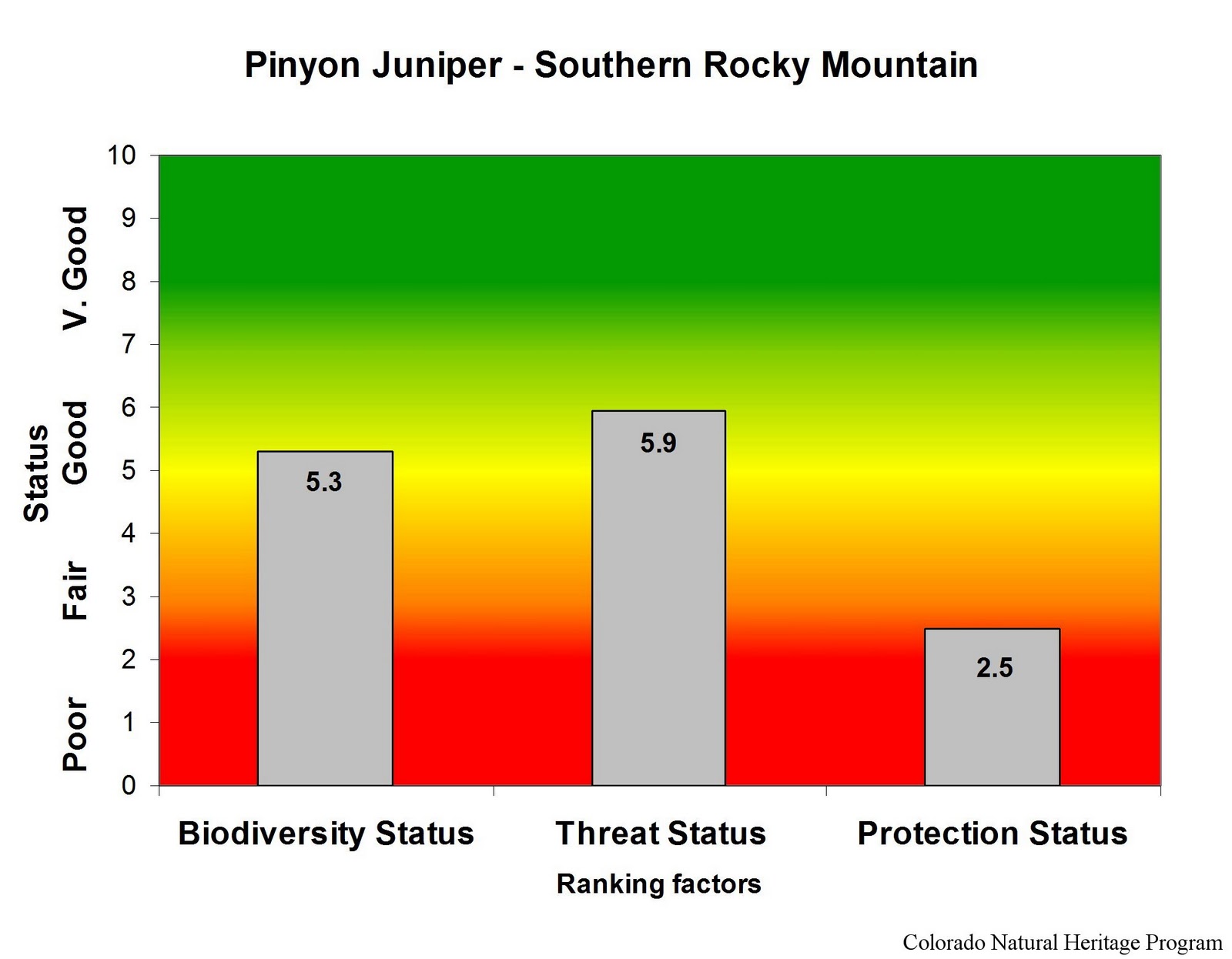
The Southern Rocky Mountain Pinyon-Juniper ecological system is similar to the Colorado Plateau Pinyon-Juniper system, but with a more restricted distribution in south central Colorado. In Colorado, the southern Rocky Mountain pinyon-juniper woodlands are found in the south central part of the state, around the San Luis Valley, southern mountain front east to Mesa de Maya, and north to the Arkansas River Valley and Palmer divide. Elevations range from about 5,000 to 9,000 feet. Pinyon-juniper also occurs in a limited distribution on the eastern plains near the Purgatoire River. These are open woodlands of warm, dry sites on mountain slopes, mesas, plateaus, and ridges. Pinyon pine and/or one-seed juniper dominate the tree layer, and Rocky Mountain juniper may be present at higher elevations. In the canyons and tablelands to the east, pinyon is absent, and this system is replaced by the Southern Rocky Mountain Juniper Woodland and Savanna system. Understory layers are variable and may be dominated by shrubs, grasses, sparse vegetation, or bare ground.

Southern Rocky Mountain pinyon-juniper covers some 1.25 million acres in Colorado. Ownership is divided about equally between private and public ownership, with the Bureau of Land Management responsible for the majority of federal holdings. Pinyon-juniper ecological systems have declined in both extent and quality compared to historic norms, although there are a number of very large patches remaining. Threats include urban development, recreation (especially motorized recreation), invasive species (most notably an increase in cheatgrass in the understory, which has led to increasing fire ignitions), and energy development.


Overall biodiversity, threat, and protection status scores for
Colorado Plateau Pinyon-Juniper in Colorado.
 
 
 A "windrose" graph depicting Colorado Plateau Pinyon-Juniper status for individual scoring factors.

Tuesday, November 29, 2011

Ecological Systems: Sagebrush Shrublands


There are two major types of sagebrush ecological systems in Colorado: big sagebrush shrublands and montane sagebrush steppe. These shrublands occur throughout much of the western United States. Although they can be found on Colorado’s east slope, the largest occurrences are on the western slope. North Park, Middle Park, and the upper Gunnison Basin have extensive stands of sagebrush shrublands.

     Big sagebrush shrublands in western Colorado.

Big sagebrush shrublands are typically found in broad basins between mountain ranges, on plains and foothills. Big sagebrush shrublands are characterized by a dense stands of taller sagebrush species with a significant herbaceous understory, and are generally found at elevations from 5,000 to 7,500 feet. Taller shrubs distinguish the big sagebrush shrubland ecological system from the montane sagebrush steppe shrublands, which are dominated by shorter sagebrush species.

Montane sagebrush, Gunnison County, Colorado.

Montane sagebrush steppe primarily occurs on ridges, near flat ridgetops, and mountain slopes. Montane sagebrush stands are usually found at elevations from 7,000 to 10,000 feet, often adjacent to the lower elevation big sagebrush shrublands.

Sagebrush shrublands provide food and shelter for many small mammal and bird species. The most significant at-risk animal species in Colorado’s sagebrush ecosystem is the Gunnison Sage Grouse, ranked “critically imperiled” (G1S1) by the Colorado Natural Heritage Program, and listed as a Tier 1 Species of Greatest Conservation need by the Colorado Division of Wildlife. Other Tier 1 Species of Greatest Conservation Need that are found exclusively (or almost exclusively) in sagebrush habitats are Greater Sage Grouse, Brewer’s Sparrow and Sage Sparrow. In addition, several of Colorado’s rarest plants are found primarily in sagebrush habitats. These include the federally listed (Endangered) Osterhout’s milkvetch, as well as several other globally rare members of the milkvetch family (Gunnison milkvetch, violet milkvetch, and skiff milkvetch). Other rare Colorado plants that are most commonly found in sagebrush habitats are the globally rare narrow-leaf evening primrose, Bessey locoweed, Fremont’s beardtongue, and Harrington’s beardtongue.

Many of Colorado’s sagebrush shrublands are vulnerable to changes induced by domestic livestock grazing. Over the past century the condition of much of Colorado’s sagebrush shrubland has been degraded due to fire suppression and heavy livestock grazing. Although many livestock operations are now more sensitive in their treatment of sagebrush habitats than they once were, recovery in these systems is slow. Furthermore, many remaining sagebrush patches are now being fragmented by fast-paced and widespread energy development.

Overall biodiversity, threat, and protection status scores for sagebrush shrubland in Colorado.

 A "windrose" graph depicting sagebrush status for individual scoring factors.

Friday, November 4, 2011

Nine new Rare Plant Conservation Initiative reports available

Ipomopsis polyantha. Photo by David G. Anderson.

Phew! In a flurry of activity, CNHP and TNC Botanists and Conservation Planners have finalized a whopping 9 new reports for both statewide and local Conservation Action Plans as a part of the collaborative Colorado Rare Plant Conservation Initiative.

The reports are:
  • Arkansas Valley Action Plan 2011 Update
  • Big Gypsum Valley and Dry Creek Basin Preliminary Action Plan
  • Colorado Wildlife Action Plan: proposed rare plant addendum
  • Gateway Preliminary Action Plan
  • Middle Park Action Plan 2011 Update
  • North Park Action Plan 2011 Update
  • Pagosa Springs Action Plan 2011 Update
  • Piceance Basin Action Plan 2011 Update
  • Plateau Creek and Miramonte Reservoir West Preliminary Action Plan
Each report is available in PDF form from our Documents and Reports page, as well as from our Botany Team page.

Tuesday, October 25, 2011

Ecological Systems: Mixed Conifer Forest


These are mixed-conifer forests occurring on all aspects at elevations ranging from 4,000 to 10,800 feet. Douglas-fir and white fir are the most common dominant trees, but as many as seven different conifer species may be present. In many areas of the state these forests form a matrix with large stands of other forest types such as ponderosa pine or aspen. Natural fire processes in mixed conifer stands are probably highly variable in both return interval and severity. Douglas-fir stands are characteristic of drier sites, often mixed with ponderosa pine. More mesic stands are found in cool ravines and on north-facing slopes, and are likely to be dominated by white fir with blue spruce or quaking aspen stands. Fire in these cool, moist stands is infrequent, and the understory may be quite diverse.

A number of common and rarer bird species may be found in these forests, including the white-crowned sparrow, mountain bluebird, Clark’s nutcracker, Williamson’s sapsucker, and red-naped sapsucker.

Mixed conifer forests cover more than 850,000 acres in Colorado. Nearly 70% of this area is federal lands, primarily those managed by the US Forest Service, but lacking wilderness designation. A substantial portion (15%) is on private land. Consequently, these habitats are generally in good condition, with minimal threats, and reasonable protection. Occurrences in the Front Range are vulnerable to the impacts of housing development, while those in western Colorado are often adjacent to active oil and gas development.

Overall biodiversity, threat, and protection status scores for mixed conifer forests in Colorado.

 A "windrose" graph depicting mixed conifer status for individual scoring factors.  

Tuesday, August 2, 2011

Ecological systems: Grasslands


Grasslands other than those of the Shortgrass Prairie in Colorado can be classified into three major groups: Western Great Plains Foothill and Piedmont Grassland, Southern Rocky Mountain Montane-Subalpine Grassland, and Inter-Mountain Basins Semi-Desert Grassland. Together these grasslands types cover about three million acres in our state.

Foothill and piedmont grasslands are found at the extreme western edge of the Great Plains, where increasing elevation and precipitation facilitate the development of mixed to tallgrass associations on certain soils. These grasslands typically occur at elevations between 5,250 and 7,200 ft. Typical species include big bluestem, little bluestem, needle-and-thread. 

 Foothill-piedmont grassland - Rocky Flats area.

Montane-subalpine grasslands in the Colorado Rockies are found at elevations of 7,200-10,000 feet, intermixed with stands of spruce-fir, lodgepole, ponderosa, and aspen forests, or as the matrix community in the large intermountain basin of South Park. Lower elevation montane grasslands are more xeric, while upper montane or subalpine grasslands are more mesic. Typical species include fescue, muhly, oatgrass, and others. 

Montane grassland - Mineral County

Colorado’s semi-desert grasslands are found primarily on dry plains and mesas of the west slope at elevations of 4,750-7,600 feet. These grasslands are typically dominated by drought-resistant perennial bunch grasses such as bluebunch wheatgrass, blue grama, galleta grass, and needle-and-thread, and may include scattered shrubs.

 Semi-desert grassland - Mesa County

Common species characteristic of these grasslands include the vesper sparrow, mountain bluebird, Brewer’s blackbird, and white-tailed jack rabbit. Rarer species are the Gunnison’s prairie dog and a variety of skipper butterflies. Impacts from human activity other than domestic livestock grazing are low for most of these grasslands, although a significant portion of historic occurrances have been lost through habitat conversion. The majority of Colorado’s grassland acreage is on privately owned lands, although much of the montane grasslands are on federal land managed by the USFS or the BLM. Although many of our remaining occurrences are in good condition, protection for these grasslands is generally lacking. 

Overall biodiversity, threat, and protection status scores for grasslands in Colorado.
 
A "windrose" graph depicting grassland status for individual scoring factors.

Wednesday, May 18, 2011

Ecological Systems: Oak - Mixed Mountain Shrublands

Oak shrubland (foreground) in Archuleta County

These are montane shrublands generally occurring at elevations from approximately 6,500 to 9,500 feet, where they are often situated above pinyon-juniper woodlands. Gambel oak is typically dominant, but very often mixed with other montane shrubs such as serviceberry, mountain mahogany, antelope bitterbrush, big sagebrush, chokecherry, and snowberry. This ecological system intergrades with the foothills shrubland system and shares many of the same site characteristics. In Colorado, oak and mixed mountain shrublands are most common on the west slope, where they form extensive bands on the lower mountain slopes, plateaus, and dry foothills. In eastern Colorado these shrublands are also found at the mountain front as far north as the Palmer Divide. These shrublands may form dense thickets, or occur as open shrublands with an herbaceous understory. Although this is a shrub-dominated system, some trees may be present. Fire typically plays an important role in this system, causing shrub die-back in some areas, promoting stump sprouting of the shrubs in other areas, and controlling the invasion of trees into the shrubland system.

 Oak shrubland (not leafed out yet) in Douglas County

As with foothills shrublands, there are few common or rare species exclusively associated with oak-mixed mountain shrublands. A variety of small mammals, including squirrels and woodrats, and birds such as rufous-sided towhee, green-tailed towhee, and Virginia’s warbler use these habitats. Larger mammals such as mule deer, black bear, and mountain lion may take advantage of the cover and food sources offered by thick shrublands.

These shrublands account for about 2.7 million acres in Colorado, more than 50% of it on privately owned land. Other substantial tracts are on state and federally owned lands, especially those managed by the US Forest Service and Bureau of Land Management, and occasionally within non-wilderness protected areas. These shrublands are weakly protected in Colorado, but are generally in good condition. Impacts include housing development and oil and gas development.

Overall biodiversity, threat, and protection status scores for oak shrublands in Colorado.

A "windrose" graph depicting oak shrubland status for individual scoring factors.

Tuesday, April 19, 2011

Ecological Systems: Sandsage Shrubland

These shrublands dominate sandy areas on Colorado’s eastern plains, where they often intermingle with shortgrass prairie to form a locally patchy sandsage-shortgrass matrix. Occurrences are characterized by sand sagebrush with an understory of tall, mid- or short grasses and scattered forbs. Yucca and snakeweed are common in some areas. A variety of small mammals and burrowing reptiles live here where soils are easy to excavate. Typical species include kangaroo rats, plains pocket mice, grasshopper mice, western rattlesnakes, and western hognose snakes. Rarer species that are typical of this habitat include greater and lesser prairie-chickens, Cassin’s sparrows, and ornate box turtles.  Fire and grazing are the most important dynamic processes for sandsage ecosystems, although drought stress can impact this system significantly in some areas. 

Sand sage shrublands cover nearly two million acres in Colorado, and more than 80% of this is on private lands. State lands and federal lands managed by the US Forest Service account most for the remaining area. Although these sandy-soiled habitats have frequently been passed over while neighboring grasslands are converted to agriculture, and remaining tracts are generally in good condition, some 20% of historic coverage has been lost. The sand sage ecological system is poorly conserved in Colorado, with few patches in protected areas. These shrublands in Colorado are vulnerable to adverse impacts from energy development (including both wind and oil and gas).

Overall biodiversity, threat, and protection status scores for sandsage in Colorado.

 A "windrose" graph depicting sandsage status for individual scoring factors.