Showing posts with label Threatened and Endangered Species. Show all posts

Friday, September 4, 2015

Rare Orchid Surveys Yield Low Numbers in West Denver

In late August, our botany team explored areas of West Denver hoping to relocate populations of the rare Ute ladies' tresses orchid (Spiranthes diluvialis). The orchid, which is listed as Threatened by the U.S. Fish and Wildlife Service, has highly fluctuating population numbers from year to year. Last year in August 2014, no orchids were found at the West Denver occurrence. This summer, Pam Smith and Bernadette Kuhn were only able to locate six orchids at a location where hundreds have previously been documented. The orchids contain an array of flowers that curve along the top of the plant, like a white spiral staircase. Once the orchid's white flowers turn brown and the fruits mature, the plants are nearly impossible to spot in the tall grasses, rushes, and coyote willows that are typically found in suitable Ute ladies' tresses habitat. Only one of the orchids this year was in bloom (see photo below). While surveying, we were excited to spot a monarch butterfly resting in a plains cottonwood (see second photo below).

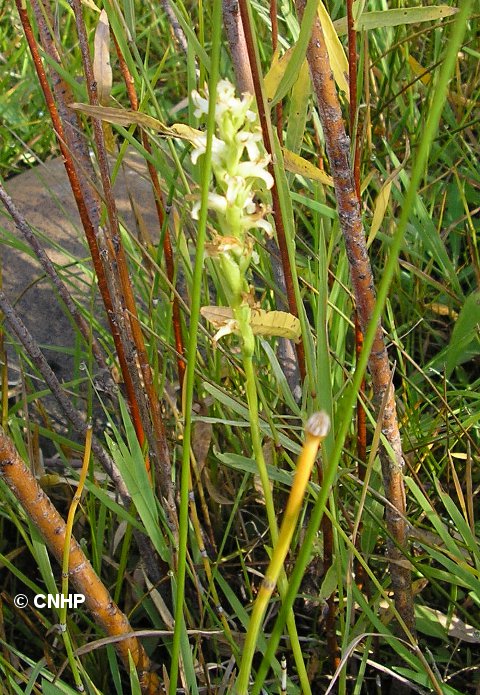
The lovely, rare and Threatened Ute ladies' tresses orchid (Spiranthes diluvialis) in bloom.
A monarch butterfly rests in a plains cottonwood tree in West Denver.

Monday, July 6, 2015

Provide Your Comments for the Newly Updated Colorado Rare Plant Guide

By Susan Panjabi

The Colorado Rare Plant Guide now contains updated species profiles for rare plants listed as Candidate, Threatened, or Endangered by the U.S. Fish and Wildlife Service. CNHP botanist Susan Panjabi is accepting comment on these species profiles through July 31, 2015. The profiles contain new, beautiful artwork by the Rocky Mountain Society of Botanical Artists, as well as photographs by local botanists. Mancos milkvetch (Astragalus humillimus) is an excellent example of an updated profile, with new photos from botanist Steve O'Kane, and artwork by Vanessa Martin (see drawing below). Mancos milkvetch is a federally listed Endangered plant known from a small area in southwestern Colorado and northwestern New Mexico. Please contact Susan with edits, as well as any additional information, photographs or artwork related to these rare plant species.

A drawing of Mancos milkvetch (Astragalus humillimus) by Vanessa Martin. Martin is a member of the Rocky Mountain Society of Botanical Artists.


Monday, March 30, 2015

The Celastrina Project:Building Future Conservation Biologists at CSU

CNHP just launched a crowdfunding campaign: The Celastrina Project! The goal of the Celastrina Project is to help Colorado State University students develop, execute, and present their own research on a rare Colorado plant, animal or ecosystem. Donations for the project will be used to pay stipends, field supplies, and travel costs for CSU students. Read more about the project, check out the Celastrina Project video, and how to donate by clicking here.

The idea for this project began in 2014, when CNHP sponsored the first Celastrina Project honors student to study the population ecology of the hops blue butterfly (Celastrina humulus), pictured above.

CSU undergraduate student Callie Puntenney presents results from her honor's thesis on hops blue butterfly population ecology.

Thursday, March 26, 2015

Gunnison Sage Grouse Conservation Easement in Dove Creek, CO


In 2006, CNHP collaborated with Colorado Parks and Wildlife biologist to create the Dove Creek Potential Conservation Area (PCA) in southwestern Colorado. This PCA was drawn to identify habitats that support one of the seven remaining populations of the federally listed Gunnison sage-grouse. As of 2014, this population (referred to as the Monticello-Dove Creek population) contains only 98 individuals, according to the final listingrule issued by U.S. Fish and Wildlife Service. Lek count data from 19 years of monitoring are generally well below the Rangewide Conservation Plan population target of 500 breeding birds.

In recent years, in an effort to reverse the population trend, Montezuma Land Conservancy has worked with private landowners to conserve important sage-grouse habitat with conservation easements.  Since 2012, the Conservancy has conserved 3,340 acres of occupied habitat for the Gunnison sage-grouse – 2,700 of which is located within the CNHP Dove Creek PCA. The most recent project protected approximately 680 acres of the Dove Creek PCA under a conservation easement. The property contains sagebrush habitats, as well as areas formerly used to grow dryland pinto bean crops which have been replanted into sage brush.  The conservation easement contains a total of 788 acres, and borders BLM land and the Coalbed Canyon State Wildlife Area.


Sagebrush habitats and former pinto bean cropland near Dove Creek, Colorado offer habitat for Gunnison sage-grouse, a species listed as threatened in 2014 by the U.S. Fish and Wildlife Service.


Tuesday, February 3, 2015

Boom or Bust: Searching for Ute Ladies-Tresses Orchids

Winter in Fort Collins has us reminiscing about the 2014 field season. Last summer we searched for a lovely white orchid called Ute ladies-tresses (Spiranthes diluvialis). This federally threatened orchid prefers moist areas adjacent to creeks and rivers, and is also found in wet meadows. The population size of this species is known to fluctuate wildly. The orchid easily eludes field botanists because it spends most of the year in a dormant state with no above-ground structures or in a vegetative state with no flowers.
Figure 1. Ute ladies-tresses in full bloom.
We started our search on the West Slope of Colorado, combing 43 miles of the Colorado River from State Bridge to Dotsero. Portions of this section of the river were identified by Karin Decker as potential suitable habitat based on a model she created for the Little Snake BLM Office. CNHP ecologist Dee Malone, along with botanists from the U.S. Fish and Wildlife Service, BLM, and the Colorado Native Plant Society used rafts, kayaks, and duckies to conduct the surveys. Unfortunately, no orchids were found during the trip.

Figure 2 (top). U.S. Fish and Wildlife Service botanists Ellen Mayo (front) and Gina Glenne (back) searched for Ute ladies-tresses along the Colorado River. Figure 3 (bottom). A river otter pokes it head up to check out our flotilla.


Back on the East Slope, Pam Smith visited sites along Clear Creek where hundreds of Ute ladies-tresses had been documented in previous years. We were not able to locate any individuals in our surveys. Jill Handwerk and Bernadette Kuhn also checked a known site just outside Fort Collins with Crystal Strouse, a botanist from the City of Fort Collins Natural Areas. Still, no plants turned up. While 2014 was a bad year for the orchid, we know population sizes exhibit large annual fluctuations. Here’s hoping for a boom year in 2015.
Figure 4. Botanists Jill Handwerk (CNHP) and Crystal Strouse (City of Fort Collins) look for Ute ladies-tresses near Fort Collins. Despite the hopeful number of pin flags we brought, no orchids were found.


Tuesday, May 6, 2014

Mapping Gopher Tortoise Burrows in Louisiana

By Bernadette Kuhn, CNHP Botanist

I recently had a chance to attend a NatureServe Core Methodology training just north of New Orleans, Louisiana. Keri Landry, a wildlife biologist from the Louisiana Natural Heritage Program, and Whitney Weber from NatureServe instructed our group on how to map element occurrences for animals. The training was held north of Covington, Louisiana in a longleaf pine forest that provides habitat for the gopher tortoise. Once a widely distributed in the southeastern U.S., this species is now listed as Threatened by the U.S. Fish and Wildlife Service in Alabama, Mississippi, and Louisiana. Gopher tortoise populations have declined throughout the southeast due to the loss of longleaf pine forests, disease, hunting, and forestry practices.

Our training group spent the morning mapping gopher tortoise burrows. Keri extended a tiny camera on a flexible hose down inside two of the burrows. The camera projected an image onto a small field laptop screen, and we were able to see two gopher tortoises hunkered down in their burrows.


Keri has a tortoise-in-tow that she uses for public outreach and education. She let our group spend a few minutes admiring him up close. We were also fortunate to see the state’s southernmost documented population of Orobanche uniflora, oneflowered broomrape. This plant species, although somewhat common in Colorado, is rare in the southeast and is tracked by the Lousiana Natural Heritage Program as a G5 S1. The botanists in the group gleefully helped the LNHP staff map new populations of the delicate, parasitic plant. We were all excited to learn new ways to collect field data for element occurrences through a hands-on session in a beautiful and diverse ecosystem. Thanks to the NatureServe staff, Keri, and Amy Jenkins (Florida Natural Heritage Program) for a great training day!

Tuesday, June 18, 2013

Gunnison Basin Bioblitz!

by Hannah Bower, CNHP intern

Only those dedicated to the conservation of the rare skiff milkvetch (Astragalus microcymbus) would spend many warm windy hours hunkering over the prickly cacti and sagebrush of the Gunnison Basin to find just one individual.


Astragulus microcymbus (skiff milkvetch)

From June 4th through June 6th, ten to twelve eager explorers set out on a time-intensive BioBlitz (led by Bernadette Kuhn, botanist at CNHP) in hopes to track down more of this rare species of milkvetch. Since many of the plants were only a few centimeters tall, the search was a difficult task and some botanists came out unlucky. However, no search is for naught, and by the end of the excursion, around 115 Astragalus microcymbus individuals were identified and many new areas were explored for this field season’s search on the skiff milkvetch.

Searching, searching, searching!
Russ Japuntich (BLM), Gay Austin (BLM) and Hannah Bower  (CNHP intern)


Skiff milkvetch is a Candidate for listing under the Endangered Species Act. It is threatened by habitat fragmentation and degradation. The monitoring and surveys performed by the Bioblitz team will help us better understand the geographic extent, population numbers, and population trends of skiff milkvetch.

Just another day on the job...

Astragulus microcymbus thanks you all for your support in its species’ protection!

A big thanks to the BioBlitz trip members:
Bernadette Kuhn (CNHP Botanist)
Peggy Lyon (CNHP Botanist)
Hunter Gleason(CNHP and Mountain Studies Institute Intern)
Gay Austin (BLM Natural Resources Specialist)
Russ Japuntich (BLM Wildlife Biologist)
Gina Glenne (USFWS Botanist)
Alicia Langton (USFWS Term Botanist)
Mary Price (RMBL)
Larry Allison (volunteer)
Lynn Lewis (volunteer)
Michelle DePrenger-Levin (DBG Research Associate)
Emily Wilson (DBG intern)
Nick Waser (RMBL)

Wednesday, January 30, 2013

Reference Wetlands and Disturbance in the Lower South Platte River Basin

By Laurie Gilligan, CNHP Wetland Ecologist

Last summer, CNHP’s Erick Carlson and I were a two-person team of wetland ecology buffs who spent some plant lD-filled, glorious hours sampling wetlands and riparian areas in our home river basin - the Lower South Platte River Basin. The ‘Lower’ portion of the South Platte refers to the non-mountainous section of the basin, so we surveyed many wetlands and riparian areas in northeast Colorado’s Great Plains.

We sampled two kinds of sites:
  1. reference examples (or the best we could find) of wetlands and riparian areas as mapped by the 1970’s National Wetlands Inventory (mapping digitized right here at CNHP by Gabrielle Smith and Erick); and 
  2. reference examples of wetlands managed by Colorado Parks and Wildlife and other partners for wildlife habitat diversity and waterfowl use. 
Although no sites selected for reference sampling were located in our home city of Fort Collins, we think the random sample of wetlands scheduled for next summer’s portion of this study just may include a few in our backyard.


So what kinds of wetlands were the best of the plains? Well, quite a variety! So enjoy the pictures, and if you like what you see, in the next couple of weeks keep your eyes peeled for our Summer 2013 wetland field technician job search posting on our website! 

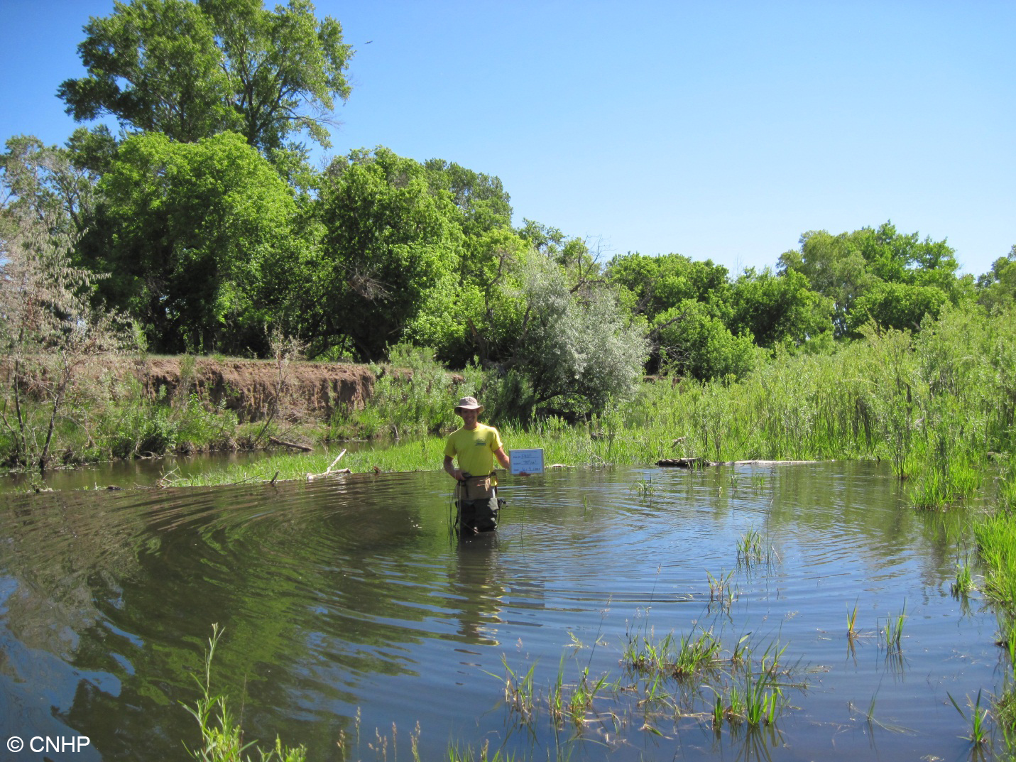
We surveyed four woody riparian wetlands abutting the Front Range Foothills. Many riparian areas in the Front Range corridor are impacted by water diversions that reduce the rivers’ capacity to flood and sustain true riverine wetlands. This can cause incised banks as you see at this site. However, sometimes natural forces like busy beavers counter these anthropogenic impacts by creating their own flooding. This riparian shrubland wetland had high plant species diversity and nice pools due to beaver effects. 

We surveyed four sites along the main stem of the South Platte River Floodplain. They say the South Platte River used to be a mile wide and an inch deep. Maybe not so anymore, but the flat landscape and wide floodplains of the Great Plains still create excellent conditions for wildlife habitat when water levels are low and flowing. The sandbars scour and braid and are colonized by big-seeded annual grasses and forbs, making perfect habitat for migratory waterfowl food and nesting. Look at all that habitat patch diversity – that’s pretty neat-ure, eh? 

Six more sites were sampled along smaller, at times ephemeral, rivers that feed into the South Platte. Not all ‘wetlands’ mapped in NWI were actually wet  - this site was sandy and dry, with an open cottonwood overstory and an understory of various native shortgrass prairie species. We were perplexed by the young cottonwoods in the wash – were they resprouts indicative of browse or grazing pressure, or did the wash flood and create a moist and open substrate suitable for new cottonwood establishment?


We surveyed five sites mapped as herbaceous wetlands. On the ground, these ranged from open mesic meadows that would not meet the federal definition of wetlands, to classical wet meadows positioned near a break in slope and supported by high water tables, to a gorgeous fen with 80 cm of peat. This wet meadow pictured had high wildflower diversity, including a strong population of Gaura neomexicana ssp. coloradensis, which is listed as federally threatened by the Endangered Species Act.  Can you spot the flowers of this plant?


We surveyed eight playas, which are shallow, depressional clay-lined wetlands that dry down for periods of time. Their shallow waters and abundant invertebrate food supply provide important habitat for migratory shorebirds in an otherwise arid portion of the western Great Plains.

Many of the playas surveyed in their dry phase hosted hidden surprises – bird nests utilizing cow dung for shade and protection!

We surveyed nine sites managed for wildlife habitat by Colorado Parks and Wildlife and other partners. This sandy depression is a recharge pond that floods and dries down seasonally, creating optimal conditions for an abundance of smartweed (Persicaria spp.), which are big-seeded, moist soil species tasty to waterfowl.  Management of this wetland proved a huge success for waterfowl, as thousands of birds were reported to use this wetland every year.

Though it has been ~40 years since the wetlands of the Lower South Platte basin were mapped, this project is the first of its kind to sample and understand the full range of wetland and riparian diversity across the basin. After a successful summer of surveying 35 reference sites, disturbance ecology proved to be the summer’s mantra. This made for an interesting field season. While landscapes that are less disturbed from anthropogenic effects are the most sought-after for reference sampling, it was a regime of natural disturbance (flooding, beaver activity, wet and dry cycles, etc.) that tied together many of these sites and made them the local gems that they are. Disturbance can be natural, and nature is variable… 

Wednesday, November 28, 2012

This Weekend: Drink a beer, help a rare plant!

Even while Colorado's globally imperiled wildflowers are dormant, we continue to strategize for their long-term protection. Pateros Creek Brewing Company has graciously agreed to help us celebrate these remarkable plants by brewing a specially crafted Extra Pale Ale named for the listed Threatened Ute’s Ladies-tresses Orchid (Spiranthes diluvialis): Spiranthes EPA!

This Weekend (11/30 - 12/02) only!
$1 per pint of Spiranthes EPA sold through the weekend will benefit the Colorado Rare Plant Conservation Initiative!

Not to worry, there isn't actually any Spiranthes in the beer.

For some extra special fun, please join CNHP staff this Friday, 11/30, from 5-8 at Pateros Creek for a special release party for this excellent beer (we've sampled it and recommend it highly!). Pateros Creek Brewing Company is located northeast of College Ave and Pine St in Old Town, Fort Collins. They do not serve food, so we will provide appetizers. Live music by Shaefer Welch of Rosewood Divine.

Wednesday, November 14, 2012

Mesa Verde cactus 20-year demographic study published

Results of a 20-year study of the Federally Listed (Threatened) Mesa Verde cactus (Sclerocactus mesae-verdae) were recently published in the journal Western North American Naturalist. CNHP ecologist Karin Decker co-authored the paper, along with Janet Coles and Tamara Naumann, both of the National Park Service.

Mancos shale - favorite habitat of Mesa Verde cactus.

Funded by the US Fish and Wildlife Service through the Colorado Natural Areas Program, the study followed individually marked cactus plants over the period from 1986 to 2005. Each year, researchers measured every cactus stem in 3 different plots in southwestern Colorado, and recorded reproductive status and damage or mortality. A total of 1629 stems were measured. At least 30 cactus plants lived through the entire study period and were still going strong when last observed. Clearly, twenty years may not be long enough for the study of some long-lived species! Read the abstract here.

This little plant is about 4 cm (1.6 inches)  in diameter, and probably at least 7 years old.

Mapped locations of rare and imperiled species and natural communities in CNHP’s database doubles in the past decade


CNHP strives to have the most comprehensive database of rare and imperiled plants, animals and unique natural communities (referred to as “elements of biodiversity” or “elements”) in Colorado. We compile data from our own field surveys and county inventories, and collect data from key partners and other professionals in the conservation community. It is nearly impossible to survey the entire state, but as a collective, we can build a comprehensive database that serves Colorado and ensures that the complex challenges of the 21st century are tackled thoughtfully and informatively.

See our latest tracking list here. If you have data for any species we track, please complete a CNHP field form and submit your data to our repository. You can download CNHP field forms or fill them out online at the CNHP data submission page.

Thanks to Colorado’s conservation community, our database has grown from 11,500 mapped locations of rare elements in 2000 to over 25,000 mapped locations in 2012. Help us double this again in the coming decade!

Graph of the number of rare and imperiled species and natural communities
that have been mapped by CNHP during the 2000 - 2012 period.

Wednesday, October 31, 2012

National Park Service Projects 2012

By Peggy Lyon and Dee Malone, CNHP botanists

We were fortunate to have projects in three national parks on the west slope this year:  Dinosaur N.M., Black Canyon N. P. and Mesa Verde N.P.   In Dinosaur during our June trip we documented Erigeron wilkenii, E. nematophyllus, Oenothera acutissima, Oxytropis besseyi  ssp. obnapiformis and several Pellaea glabella occurrences.  In July, due to the low water in the Yampa River, we were able to wade (sometimes swim) across the river and access the north side, where we found some wonderful alcove seeps with Adiantum capillis-veneris, Anticlea vaginata, Limnorchis zothecina and Cirsium ownbeyi.

An alcove seep in Dinosaur National Monument.

It  was so hot that every time we came back to the river from a foray up a canyon, we jumped right in.

CNHP botanist Peggy Lyon coolin' off in the Yampa.

In Black Canyon N.P. we established permanent monitoring protocols for Sullivantia hapemannii and Gilia penstemonoides.  This year’s drought really affected two other targeted species, Astragalus anisus and Thelypodiopsis juniperorum.  For the latter we found more dead plants from 2011 than living ones.

CNHP botanist Dee Malone in Black Canyon National Park.

In Mesa Verde Peggy with Park Service botanist Merran Owen found large new populations of Hackelia gracilenta, Astragalus deterior and Lepidium crenatum.  

Botanist Peggy Lyon in front of ruins in the Mesa Verde National Park. 

Thursday, October 18, 2012

Mapping Eutrema penlandii

by Bernadette Kuhn, CNHP Botanist

A few months ago, CNHP joined forces with botanists from the U.S. Fish and Wildlife Service and the Mosquito Range Natural Heritage Initiative to survey for rare plant in the Leadville area. The conditions were perfect. Despite a few threatening clouds, we had a bluebird survey day. After four hours of crawling through the alpine, we found what we were looking for. The tiny plant, Eutrema penlandii, is a member of the mustard family (Brassicaceae). Listed as Threatened under the Endangered Species Act, it is found primarily in wetlands and alpine fens above treeline.

Volunteer Merit Glenne at the new Eutrema penlandii site near Mt. Arkansas, outside Leadville, Colorado.

Very few populations of E. penlandii have been mapped on the west side of the Continental Divide. Our findings suggest more surveys on this side of the Divide may result in a range expansion for this narrowly distributed Colorado endemic.

Neil Peterson, Mosquito Range Natural Heritage Initiative, flags Eutrema penlandii individuals.

Eutrema penlandii in fruit.

Thursday, October 11, 2012

Population decline in the Preble’s meadow jumping mouse

Long-term population sampling for the Preble’s meadow jumping mouse (PMJM) has allowed Rob Schorr to estimate population change (λ) for the population along Monument Creek at the U.S. Air Force Academy (Academy).  Using mark-recapture techniques and a novel population model that allows estimation of survival and recruitment, Schorr estimated changes in PMJM λ from 2000-2006.  Although λ varied annually, the 7-year mean showed a declining population, and λ was less impacted by changes in PMJM survival than by changes in PMJM recruitment.
Zapus hudsonius preblei
A Preble's meadow jumping mouse (Zapus hudsonius preblei) keeps a sharp eye on the photographer.

Recruitment can be influenced by immigration or reproduction.  Given the loss of habitat along eastern tributaries of Monument Creek, there are limited opportunities for increasing immigration from these tributaries and this may be a driving force during this time.  However, Schorr warns that this may be a temporary decline that will be compensated by increased reproduction or immigration from western tributaries that are on the Academy.

Monument Creek, CO
PMJM habitat along Monument Creek.

This study will be published in the October 2012 Journal of Mammalogy.

Rob Schorr and mouse
Rob Schorr and friend. Photo by James Dwyer.

Tuesday, October 9, 2012

Treasure Fire just misses boreal toad breeding site

by Brad Lambert

The Treasure Fire that burned approximately 400 acres just east of Leadville this past summer came within a half mile of the only known boreal toad breeding site in Lake County. The boreal toad is a state endangered species with a patchy distribution throughout the central mountains of Colorado. The Birdseye Gulch population is monitored by CNHP biologists who conduct yearly visits as part of a project funded by Colorado Parks and Wildlife.

Boreal toad

The fire started on June 24th and was headed up the gulch towards the breeding pond. Fortunately the fire changed directions and missed the breeding pond. The fire was contained by July 2nd.  USFS biologist Jeni Windorski of the Leadville Ranger District was able to work with firefighters in protecting the breeding site. The toads were probably not impacted much as the riparian area was spared. CNHP resumed monitoring in August and documented the successful metamorphosis of the tadpoles in early September.

Trees burned in the Treasure Fire

Tuesday, July 24, 2012

USFWS Recovery Champion Award Ceremony

By Susan Spackman Panjabi, CNHP Senior Botanist

From left to right: Brian Kurzel (CNAP), Betsy Neely (TNC), Susan Spackman Panjabi (CNHP), and Jenny Neal (DBG), holding their USFWS Recovery Champion Award plaques and letters. Photo by David Anderson.


It was an honor to stand beside Betsy Neely (The Nature Conservancy), Jenny Neal (Denver Botanic Gardens), and Brian Kurzel (Colorado Natural Areas Program) and receive the USFWS Recovery Champion Award, presented to us on July 20. While the four of us were singled out to receive special plaques, the award acknowledges the Colorado Rare Plant Conservation Initiative (RPCI) as a whole, including all of the RPCI partners as well as our important accomplishments over the past five years. The award ceremony was well attended and took place at the Middle Park Important Plant Area, in view of two endangered plants, Astragalus osterhoutii (Osterhout's Kremmling milkvetch) and Penstemon penlandii (Middle Park penstemon, a.k.a. "Kremmling's first settlers"). This was a great opportunity to highlight RPCI's work across the state, share our successes with national and state level decision makers, and credit our local partners who are essential to meeting our goals.

Rare plant habitat on Bureau of Land Management and State lands comprising the Middle Park Important Plant Area, near the town of Kremmling, in Grand county, Colorado. Photo by David Anderson.

It was also a thrill to receive letters from Senator Mark Udall and USFWS Deputy Director for Policy Gregory Siekaniec thanking me for my work with the Colorado Rare Plant Conservation Initiative and CNHP. Thank you to everyone who made the achievement of this award possible.


Astragalus osterhoutii (top) and Penstemon penlandii. The plants, while in abundance around the award ceremony, were not actually blooming at the time. So here are a couple of pictures taken in June a few years back. Photos by Susan Spackman Panjabi.

Wednesday, May 30, 2012

Lesser Prairie Chicken Habitat Monitoring

By Bernadette Kuhn, CNHP Botanist

We recently headed out to the Comanche National Grasslands to conduct research on grazing exclosures in sand-sage prairie occupied by Lesser Prairie Chicken. This species is a Candidate for listing under the Endangered Species Act. Decline of the species has been attributed to habitat degradation and fragmentation, and numbers of individuals are estimated at less than 300. The goal of our study is to determine if the vegetation in grazing exclosures meets the desirable conditions for Lesser Prairie Chicken habitat, as described by biologist Ken Giesen. Many of the exclosures were created in 1961 to provide habitat for scaled quail.

Lee Gruneau (CNHP) and Steve Olson (USFS) record vegetation height along a transect in sandsage prairie, Comanche National Grasslands.

Although we did not observe any Lesser Prairie Chickens, we were lucky enough to spot a juvenile coachwhip during our trip.

Masticophis flagellum - coachwhip snake
A curious juvenile coachwhip (Masticophis flagellum) raises its head to check us out.

We started our fieldwork on the heels of a rainstorm, so floral displays in the sandsage prairie were impressive. Lee and Renée spotted a Texas horned lizard and an ornate box turtle underneath the cover of blooming forb species.

Phrynosoma cornutum
A Texas horned lizard (Phrynosoma cornutum) peeks out of the orange flowers of globemallow (Sphaeralcea coccinea) and the yellow-petaled (Zinnia grandiflora).
Terrapenne ornata
This tiny Ornate box turtle (Terrapenne ornata) was hiding under a Russian thistle tumbleweed (Salsola tragus).

This is a multi-year study in collaboration with the U.S. Forest Service, and the results will help biologists on the Comanche manage this area for Lesser Prairie Chicken habitat.

Stephanie Shively, USFS wildlife biologist, guides a meter tape underneath the exclosure fence.

Wednesday, May 9, 2012

Field Trip to Columbia Gorge with WNHP

by Kirstin Holfelder, Database Developer and Assistant Database Administrator

As an ecologist turned data manager, I was particularly looking forward to getting out during the field trips that kicked off the 2012 Biodiversity without Boundaries meeting. There’s nothing more fun than hiking with botanists, ornithologists, and entomologists; people who are passionate about their science. You may only cover a half a mile of ground every two hours, but you will know that half mile very well.

Washington NHP director John Gammon and Robin Dobson, an ecologist who helped establish the Columbia River Gorge National Scenic Area, co-lead a trip that started in the lush forests of the Cascade Range’s western slope and travelled up the Columbia Gorge to the drier eastern side. We couldn’t have had more knowledgeable guides to the cultural and natural history of the area.

Temperate rain forest on the western side of the Cascade range (photo by Kirstin Holfelder)
The Columbia Gorge is a canyon that marks the state line between Washington and Oregon. It was formed largely during the last ice age by the Missoula Floods. It seems there was a glacial lake up there in Montana that periodically broke through its ice dam to release the epic quantities of water required to carve a gorge 80 miles long and 4000 feet deep. The unique geological history is echoed by the biodiversity of the area. Temperate rainforests transition to dry woodlands, then to grasslands as you travel east along a decreasing rainfall gradient. We ended our day in ponderosa pine meadows that bear a striking resemblance to Colorado’s Front Range.

Ponderosa pine meadow, looking east towards the dry grasslands of the Columbia Plateau (photo by Kirstin Holfelder)
Late April is a wonderful time to visit, because many of the wildflowers are blooming. I admit I may have contributed to the slow pace of the hike by stopping to take half a dozen pictures of each. My favorite by far was death camas (Zigadenus venenosus). It is a poisonous plant that looks unfortunately similar to members of the edible Camassia genus when not in flower. The Camassias were a staple food source for Native Americans in the area, so it’s not hard to see how death camas got its name.

Death camas in a field of wild flowers (photo by Kirstin Holfelder)
Throughout the field trip, Robin and John talked about the collaboration between scientists, land owners, and interest groups that made the creation and management of the scenic area possible. As I strolled through wildflowers and observed endangered western pond turtles, I got to personally experience how amazing the results of such cooperation can be. When interested people committed to working together make informed decisions, it’s truly amazing what we can accomplish.