Wednesday, May 30, 2012

Lesser Prairie Chicken Habitat Monitoring

By Bernadette Kuhn, CNHP Botanist

We recently headed out to the Comanche National Grasslands to conduct research on grazing exclosures in sand-sage prairie occupied by Lesser Prairie Chicken. This species is a Candidate for listing under the Endangered Species Act. Decline of the species has been attributed to habitat degradation and fragmentation, and numbers of individuals are estimated at less than 300. The goal of our study is to determine if the vegetation in grazing exclosures meets the desirable conditions for Lesser Prairie Chicken habitat, as described by biologist Ken Giesen. Many of the exclosures were created in 1961 to provide habitat for scaled quail.

Lee Gruneau (CNHP) and Steve Olson (USFS) record vegetation height along a transect in sandsage prairie, Comanche National Grasslands.

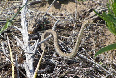
Although we did not observe any Lesser Prairie Chickens, we were lucky enough to spot a juvenile coachwhip during our trip.

Masticophis flagellum - coachwhip snake
A curious juvenile coachwhip (Masticophis flagellum) raises its head to check us out.

We started our fieldwork on the heels of a rainstorm, so floral displays in the sandsage prairie were impressive. Lee and Renée spotted a Texas horned lizard and an ornate box turtle underneath the cover of blooming forb species.

Phrynosoma cornutum
A Texas horned lizard (Phrynosoma cornutum) peeks out of the orange flowers of globemallow (Sphaeralcea coccinea) and the yellow-petaled (Zinnia grandiflora).
Terrapenne ornata
This tiny Ornate box turtle (Terrapenne ornata) was hiding under a Russian thistle tumbleweed (Salsola tragus).

This is a multi-year study in collaboration with the U.S. Forest Service, and the results will help biologists on the Comanche manage this area for Lesser Prairie Chicken habitat.

Stephanie Shively, USFS wildlife biologist, guides a meter tape underneath the exclosure fence.

Thursday, May 24, 2012

NNL 50th Anniversary

CNHP Director Dave Anderson recently attended a reception celebrating the 50th anniversary of the National Park Service's (NPS) National Natural Landmarks (NNL) Program. The event was held on the Anschutz Family Sky Terrace at the Denver Museum of Nature and Science at the end of a beautiful Colorado day.

NPS Director Jonathan Jarvis (center) with the staff of the NNL program.


There are currently 12 designated Landmarks in Colorado, and CNHP has been assisting the NPS to increase this number. The Hanging Lake NNL was designated in 2011 as a result of these efforts, and the official designation plaque was presented at the event.

US Forest Service personnel accepting the designation plaque for Hanging Lake NNL.

Congratulations to National Natural Landmarks Coordinator Heather Germaine for organizing a fantastic event!

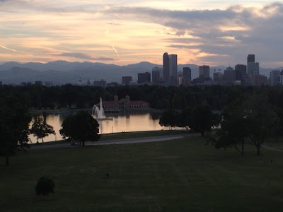
View from the Sky Terrace looking towards the Denver skyline. There are actually three NNLs visible from here (Summit Lake, the Morrison-Golden Fossil Area, and Roxborough State Park). 

Thursday, May 17, 2012

Volunteer Power: The New CNHP Wetland Mini-Herbarium

After several months of hard work and attention to detail from our awesome aspiring-botanist volunteers, we now have a mini-wetland herbarium at CNHP. As a result, Julie White, a wildlife biology major/restoration ecology minor at Colorado State University, has achieved five-star celebrity status at our wetlands program. She dedicated several hours per week of volunteer time for an entire semester to this project; sorting plants, updating nomenclature, and identifying high quality pressed specimens from 4 years of field survey plant samples. She has been involved in this project from beginning to end, her organizational skills are excellent, and there is no doubt she’s learned to sight-ID many wetland families and genera in the process.

CNHP volunteer Julie White completing the last bin from the herbarium project.
 Not only will this wetland herbarium be invaluable to botanical training for many field seasons to come, but an in-office wetland herbarium will streamline post-field plant identification. We expect that this new resource will save us huge amounts of time each year. Alex Dameron and Sere Williams were also key contributors who gave many volunteer hours to the earlier stages of the herbarium project. We can’t thank our volunteers enough for their generous time contributions and hard work!

This 4-foot stack of empty plastic bins was once full of pressed plants from many sites and years of field surveys. Now to our wetland team’s delight, these have been distilled into the best specimens of each species, organized and sorted by taxonomy for future reference!

Tuesday, May 15, 2012

Species Modeling at BWB2012

By Gabrielle Smith, CNHP Wetland Mapping and GIS Specialist

This year’s NatureServe Biodiversity without Boundaries (BWB) conference took place in Portland, OR and we lucked out with a week of unusually sunny weather. The conference was a great opportunity to meet staff from other Natural Heritage programs and learn about their work. I attended sessions focused on mapping and modeling and learned a great deal. One of the early talks was on the subject of increasing modeling capacity at the various programs, and on that note, I went out to receive some training.

The highlight of the trip for me was an R training workshop held at the Oregon Biodiversity Information Center on the Portland State University Campus. The training was led by Emile Henderson of the Oregon Biodiversity Information Center and Tim Howard from the New York Natural Heritage Program. The workshop was focused on building species distribution models using the RandomForest ensemble classifier object in the statistical software package R.

R Project Logo, courtesy of http://www.r-project.org/
The R Project - Not just a letter of the alphabet anymore.

The basic concept of species distribution modeling is that you know locations where a species has been observed and you also know things about the environment at the locations where the species have been observed. If you have many species observations, and many range-wide GIS data layers that represent variables such as elevation, aspect, annual precipitation, soils, geology and many other variables, you can combine these pieces of information to create a profile of environmental variables that supports the species. Then you can look at other places, places the species has not been observed and say “do the environmental variables at this location match up to what I know about where this species likes to live?”

Ipomopsis globularis species distribution map
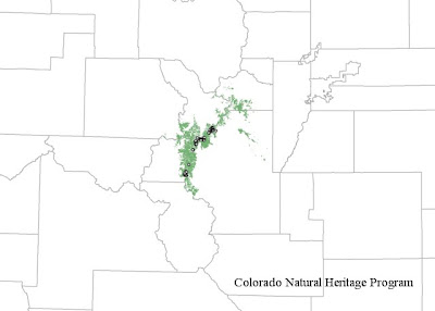
A CNHP created species distribution model for Ipomopsis globularis (globe gilia), a rare plant found only in the mountains of Colorado (click for larger version). The dots show the known occurrences of the species, the green shows the results of the model, suggesting other places to look for the species.


The output of the modeling process is a raster (cell-based) dataset that for each cell includes a probability of the species occurring in that cell location. The modeler can set a probability threshold so they can effectively say “show me every raster cell that has a 75% or greater chance of my species of interest occurring in that cell.” The resulting species distribution model can guide future field surveys of the species of interest or guide conservation planning action. Models are no substitute for on-the-ground field work and observations, but they can be a useful tool to guide fieldwork and discover the qualities that make habitat suitable for a species.

A long term goal of modeling all tracked species by all member programs emerged from this year’s BWB conference. A challenging goal to be sure, but one that I hope to help CNHP achieve!

Thursday, May 10, 2012

Field Botanists Wanted!

The view from Jackson Lake, Grand Teton National Park. Photo courtesy of Monica Kopp, one of our GLORIA volunteers from last year.

CNHP is looking for qualified volunteer field botanists to assist with a project in Grand Teton National Park, Wyoming. All travel expenses will be paid, including per diem. Transportation is provided. Work will be in early August, for approximately 10 days.

The project involves sampling vegetation at high elevation monitoring sites in the Park. Work involves backcountry travel and volunteers must be willing to backpack. This research is part of the GLORIA project, a global observation network for the comparative study of climate change impacts on alpine biodiversity. Data from the project will be used to examine climate-induced changes of vegetation cover, species composition, and species migration. For more details, contact Bernadette Kuhn or Joe Stevens.

Wednesday, May 9, 2012

Field Trip to Columbia Gorge with WNHP

by Kirstin Holfelder, Database Developer and Assistant Database Administrator

As an ecologist turned data manager, I was particularly looking forward to getting out during the field trips that kicked off the 2012 Biodiversity without Boundaries meeting. There’s nothing more fun than hiking with botanists, ornithologists, and entomologists; people who are passionate about their science. You may only cover a half a mile of ground every two hours, but you will know that half mile very well.

Washington NHP director John Gammon and Robin Dobson, an ecologist who helped establish the Columbia River Gorge National Scenic Area, co-lead a trip that started in the lush forests of the Cascade Range’s western slope and travelled up the Columbia Gorge to the drier eastern side. We couldn’t have had more knowledgeable guides to the cultural and natural history of the area.

Temperate rain forest on the western side of the Cascade range (photo by Kirstin Holfelder)
The Columbia Gorge is a canyon that marks the state line between Washington and Oregon. It was formed largely during the last ice age by the Missoula Floods. It seems there was a glacial lake up there in Montana that periodically broke through its ice dam to release the epic quantities of water required to carve a gorge 80 miles long and 4000 feet deep. The unique geological history is echoed by the biodiversity of the area. Temperate rainforests transition to dry woodlands, then to grasslands as you travel east along a decreasing rainfall gradient. We ended our day in ponderosa pine meadows that bear a striking resemblance to Colorado’s Front Range.

Ponderosa pine meadow, looking east towards the dry grasslands of the Columbia Plateau (photo by Kirstin Holfelder)
Late April is a wonderful time to visit, because many of the wildflowers are blooming. I admit I may have contributed to the slow pace of the hike by stopping to take half a dozen pictures of each. My favorite by far was death camas (Zigadenus venenosus). It is a poisonous plant that looks unfortunately similar to members of the edible Camassia genus when not in flower. The Camassias were a staple food source for Native Americans in the area, so it’s not hard to see how death camas got its name.

Death camas in a field of wild flowers (photo by Kirstin Holfelder)
Throughout the field trip, Robin and John talked about the collaboration between scientists, land owners, and interest groups that made the creation and management of the scenic area possible. As I strolled through wildflowers and observed endangered western pond turtles, I got to personally experience how amazing the results of such cooperation can be. When interested people committed to working together make informed decisions, it’s truly amazing what we can accomplish.

Tuesday, May 8, 2012

Congratulations to the Washington Natural Heritage Program

by David G. Anderson

Eight CNHP staff attended the Biodiversity Without Boundaries (BWB) conference this year in Portland, Oregon. BWB is hosted by NatureServe in April every year and is a gathering of the members of the Network of Natural Heritage Programs and their broad group of partners. The conference was excellent this year and included numerous highlights that we will share in a few subsequent blogs.

One exciting event for Colorado was to help celebrate the Washington Natural Heritage Program’s receipt of the NatureServe’s Member Program Conservation Achievement Award this year! This is very exciting to us because of our numerous ties with Washington NHP. Our closest tie is a former employee, Joe Rocchio, who moved to the Washington NHP in 2007. While working at CNHP Joe, with scientists at NatureServe and the Environmental Protection Agency, began developing methods for Ecological Integrity Assessment (EIA) for wetland plant communities. He has spearheaded efforts to use these methods to create a much more rigorous and transparent approach to assigning element occurrence ranks to individual occurrences of plant communities.

John Gamon, the director of the Washington Natural Heritage Program (at podium) accepts the Member Program Conservation Achievement Award. Joe Rocchio, WNHP Ecologist (in plaid shirt) listens along with Mary Klein, CEO of NatureServe (seated), and another WNHP staff member (background). Photo by Dave Anderson.

Joe has continued to develop these methods at Washington NHP. Washington has now developed EIAs for 67 plant communities in Washington including numerous upland types. Congratulations to Washington NHP for their success and leadership!

Wednesday, May 2, 2012

Adopt-a-Rare Plant Trainings 2012

The Adopt-a-Rare Plant Program (ARP), was revived last year as a collaborative effort between the Colorado Natural Heritage Program (CNHP), Denver Botanic Gardens, and the Colorado Native Plant Society after a several-year hiatus.  The program was revived in order to update records of the increasing numbers of rare plant populations that had become "historic", meaning that they have not been observed in over 20 years.  In addition, these plant occurrences, which were last seen in the mid-1980s were documented before GPS was widely-available, so their locations were not precisely mapped. 

When it comes to imperiled species in Colorado, 75% are plants. CNHP tracks more than 500 plant species.  With limited people and financial resources to update records, the ARP program is designed to increase the impact that volunteers can have on conserving our rarest plants.  So last year CNHP and the Botanic Gardens trained more than 30 new volunteers to help rediscover lost populations.  During the field season these volunteers spent over 325 hours scouring the countryside.  They visited 17 species at 25 sites and relocated 15 historical occurrences.

Astragalus detritalis
Astragalus detritalis (debris milkvetch) is a S2-G3 plant found in just a couple of counties in Colorado and Wyoming. Photo by ARP volunteer Larry Allison.

The program was such a success that additional trainings were held this spring. The first was held in February at the Denver Botanic Gardens, and the second was just completed in April at the Yampa River Botanical Gardens in Steamboat Springs. We now have over 60 citizen scientists trained and ready to volunteer their time to find rare plants in Colorado.

Ipomosis globularis
Ipomopsis globularis (globe gilia) is a S2-G2 plant found only in Colorado. Photo by ARP volunteer Suzanne Wuerthele.
Ipomosis globularis habitat
Ipomosis globularis habitat. Photo by ARP volunteer Suzanne Wuerthele.

If you’d like to participate in the program, we need help entering the data from the 2011 visits into our database. Contact CNHP Botanist Jill Handwerk for more information.