Showing posts with label Field Techniques. Show all posts

Monday, April 18, 2016

CNHP Helps CSU Students Build Field Sampling Skills

Last week CNHP staff members, along with CSU professors Tara Teel and Terra Sampson, spent a day in the field with graduate students from the Conservation Leadership Through Learning Program (CLTL). The CLTL is an innovative graduate program that teaches students how to confront conservation challenges and sustainability from a variety of perspectives. This year’s student cohorts are wrapping up their second semester at CSU, and will spend the last two semesters of their graduate work in places like Kenya, Peru and Namibia.

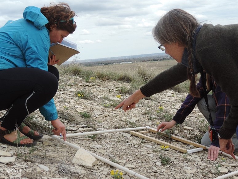
Pam Smith, CNHP Botanist (right), shows a CLTL student (left) how to identify the rare plant Bell's twinpod (Physaria bellii).
CNHP staff members Pam Smith, Jeremy Siemers and Susan Panjabi, along with Director Dave Anderson and Crystal Strouse from the City of Fort Collins Natural Areas Department, taught CLTL students basic field survey methods and resource management skills at Coyote Ridge Natural Areas in Fort Collins. The students learned about resource management challenges and successes from Crystal Strouse, City of Fort Collins Natural Areas Department Botanist. CNHP staff discussed issues with prairie dog management and rare plant management in public parks. The students got hands on training collecting qualitative and quantitative field data using different kinds of sampling plots and photo monitoring points. The CLTL students can use these field skills to design similar studies as they head out to their study sites across the world.

CLTL graduate students learn to sample vegetation plots at Coyote Ridge Natural Area, Fort Collins.
CLTL students preparing to go out in the field at Coyote Ridge Natural Area after an introduction from Crystal Strouse (left), City of Fort Collins.

Tuesday, July 21, 2015

Free Wetland Training in Colorado Springs, Sept 9-10, 2015

CNHP is excited to offer a free training on the Ecological Integrity Assessment (EIA) method for assessing wetland condition. The training will be limited to 20 participants. The course will be taught by CNHP wetland ecologists Joanna Lemly and Laurie Gilligan. The training will be help Sept 9-10, 2015 at Colorado Parks and Wildlife Regional Office in Colorado Springs. Training sessions will be held from 9am-4pm on both days. Day 1 will be in the classroom, Day 2 will be held at a nearby wetland. Please RSVP to Joanna Lemly or 970-491-2127) to reserve your spot. 


The EIA method for wetlands has been developed and refined over 10 years by NatureServe and Natural Heritage Programs across the county and adapted for use in Colorado by CNHP. In partnership with CPW, CNHP has used the method to assess the condition of over 500 wetlands and riparian area across Colorado. The EIA method places an emphasis on biotic integrity and combines quantitative vegetation metrics will qualitative metrics that evaluation landscape context, buffer, hydrology, soils, and water quality. For more information and background on the EIA method, please visit the EIA section of NatureServe’s website.

This free training has been funded by a U.S. Environmental Protection Agency, Region 8, Wetland Program Development Grant and Colorado Parks and Wildlife.

Monday, June 22, 2015

CNHP Pilots Water Chemistry Measurements in Wetland Condition Assessments

By Laurie Gilligan, CNHP Wetland Ecologist

The wetlands team kicked off their water chemistry data collection pilot project in the Lower Arkansas Basin under perfect weather conditions: rain, lightning, mud, and more rain! All of the spring rain has filled playas that have not been saturated in years, and is greening up the Arkansas River floodplain and its marshes. These conditions will give our crew the opportunity to test how well our data collection methods work in waters with high variability in sediment and water levels. However, accessing sites safely has meant dodging the notoriously fierce thunderstorms that roll over the open southeastern plains.

Joanna Lemly, CNHP wetland ecologist, collects water samples
in a playa on the southeastern plains of Colorado.
Pools within a small stream outside Florence, Colorado provide
good habitat for native plains fish species.
CNHP is excited to add water chemistry measurements to this year’s wetland assessments. While water chemistry measurements are frequently taken in lakes and rivers, more research is needed on nutrient levels, metal loads, and other water chemistry measurements in shallow vegetated wetlands. By adding water chemistry measurements to our wetland condition assessments, we can begin to observe the relationships between the wetland’s water chemistry and its overall condition. The first step with this pilot year of water quality sampling is to refine protocols and analysis, and to get a glimpse of the range of variation in water chemistry parameters that we may see in the plains.

Playa on Bureau of Land Management (BLM) land in Huerfano County, Colorado. With extra spring moisture in 2015, many playas in the Lower Arkansas Basin showed concentric rings of vegetation-in this case, an inner ring of spreading yellowcress (Rorripa sinuata).

Friday, April 17, 2015

Botany Essentials for the 2015 Field Season

If you are out in the field already, or planning to go soon, make sure you have a copy of A Field Guide to Colorado’s Wetland Plants: Identification, Ecology, and Conservation.


If you are working in wetlands on Colorado's Eastern Slope, you can also order a copy of Common Wetland Plants of Colorado's Eastern Plains: A Field Guide. Check our website in September for the upcoming Wetland Field Guide App!


Jennifer Ackerfield, Collections Manager of the CSU Herbarium, has written a new flora for the state of Colorado. Pre-orders are now accepted at the JBRIT website.
Jennifer Ackerfield's new flora will help amateurs and professional botanists alike key out Colorado plant species like the Rocky Mountain blue columbine (Aquilegia saximontana). 


Friday, April 10, 2015

CNHP Staff Teach CSU Graduate Students Field Biology Skills

This week CNHP staff members, along with CSU professor Tara Teel, spent a day in the field with graduate students from the Conservation Leadership Through Learning Program. The CLTL is an innovative graduate program that teaches students how to confront conservation challenges and sustainability from a variety of perspectives. This year’s student cohorts are wrapping up their second semester at CSU, and will spend the last two semesters of their graduate work in either Belize or Africa.
Conservation Leadership Through Learning graduate students learn how to sample vegetation plots at Coyote Ridge Natural Area, Fort Collins.

Close-up of greater short-horned lizard at Coyote Ridge Natural Area.
CNHP staff members Pam Smith and Susan Panjabi, along with Director Dave Anderson and City of Fort Collins Natural Areas Department Botanist, taught CLTL students basic field biology skills at Pine Ridge and Coyote Ridge Natural Areas in Fort Collins. These included how to use a GPS to navigate to points, how to set up and survey different types of transects to study plants and animals. The students will use these field skills to design similar studies in Belize and Africa.
A CLTL graduate student holds a greater short-horned lizard.


Tuesday, September 2, 2014

CNHP studies little brown bats to understand stability of populations in Colorado

by Rob Schorr and Jeremy Siemers, CNHP Biologists

In 2006, a new disease called White Nose Syndrome (WNS) appeared in New York that decimated bat populations.  This disease, caused by a cold-loving fungus, appears as a white dusting on the nose of bats has progressed westward as far as Missouri, and there is fear that it will continue its deadly march through to Colorado.  Yet, if it did, would we know? The nocturnal and secretive nature of bats makes monitoring their populations challenging.  That, in addition to the fact we have little knowledge of where many bats overwinter in Colorado, would make detection of a WNS-induced decline would be all but impossible to identify. There may be an alternative, however.  We may be able to monitoring summer (breeding) populations of bats to identify population-level declines.

Bats in flight around ranch house on a star-filled night
(Photo by George Fargo)
CNHP biologists, Rob Schorr and Jeremy Siemers are collaborating with Colorado Parks and Wildlife, the Yampa Valley Land Trust, and The Nature Conservancy to monitor little brown bat (Myotis lucifugus) populations at 2 ranches in the Yampa Valley.  This summer Schorr and Siemers marked nearly 600 bats with passive integrated transponder (PIT) tags and will return in 2015 to determine how many of the bats return and use the area annually.  This level of monitoring will provide insights into population stability for a healthy population of little brown bats in Colorado.

Schorr releases a female little brown bat after marking (Photo by George Fargo)

Jeremy Siemers and Rob Schorr assembling a 12-foot-tall harp trap
for capturing bats (Photo by Paul Cryan)

Tuesday, August 13, 2013

Lower South Platte River Basin Wetland & Riparian Condition Assessment Field Season in Full Swing!

by Dave Wesolowski, CNHP Wetland Field Ecology Technician

The field season for wetland and riparian condition assessment has been rocking and rolling since the beginning of June, and we’re learning so much about the Lower South Platte Basin!  Joanna Lemly and Laurie Gilligan lead a field crew consisting of Leah Fugere, Laura Cascardi, Cole Reagan, and Dave Wesolowski.  An intensive week of training has led to a thorough investigation out on the plains and foothills of northeastern Colorado.

Laura Cascardi investigates a soil pit.


Laurie Gilligan (far right) leading an exercise during training week.  

Most folks don’t associate the South Platte River or the plains of north eastern Colorado with wetlands, but they are out there and all over the place.  Diverse, complex, and fascinating warm water sloughs, emergent marshes, wet meadows, playas, and many other systems are found throughout the study area.  Our crew camps and surveys in and around many unique areas, including Chatfield and Jackson Lake State Parks and the wonderful towns of Strasburg, Sterling and Sedgwick.  Below we see Cole surveying a pond, which at first may not seem like a wetland but is, providing excellent habitat for wildlife such as: migrating birds, fish, macroinvertebrates, and a host of other organisms.

Cole Reagan field-tests his waders for a site photo.
While the plains wetlands are beautiful and provide crucial habitat for a variety of wildlife, we tend to also find a fair amount of non-native species such as cheat grass (Anisantha tectorum).

Invasive cheat grass!
Overall, it’s been a fun and exciting field season so far.  Our field season surveying the lower South Platte River basin lasts through the end of August.  At that point, we begin analyzing data and preparing for the next basin to survey.  The Lower South Platte has proven to be an intriguing basin full of unique plants and ecological systems.  We look forward to seeing what else northeastern Colorado has to offer!  Stay tuned!

Cole Reagan, Dave Wesolowski and Leah Fugere reviewing the results of today's field survey.

Friday, March 22, 2013

CNHP helps out with Conservation Leadership Through Learning

by David Anderson, CNHP Director

On March 7th and 8th, Susan Spackman Panjabi, Pam Smith, Joanna Lemly, Rob Schorr, and David Anderson spent two days with the 20 wonderful Master’s Degree Students in the Conservation Leadership Through Learning (CLTL) Program at CSU.  The CLTL is an innovative graduate program in which students confront conservation challenges and sustainability from a variety of perspectives.   It is unique in that the students spend two semesters at CSU, followed by two semesters at ECOSUR in Chiapas, Mexico.  They will receive degrees from both universities when they complete the 17-month program.  As a part of the program they are working in groups to complete “synergistic projects” in communities that will connect them with ongoing conservation efforts.

Zoologist Rob Schorr in the classroom
On March 7th we spent the day in Drs. Mike Gavin and Jennifer Solomon’s class with the students talking about conservation and ecological research.  Susan gave them a wonderful overview of the work that the Colorado Natural Heritage Program and other programs like ours do worldwide, and how our biodiversity data translates into conservation action.  I talked about methods used in ecological research and decision making.  Then Rob introduced the students to some of the ways that animals are studied.  He helped us understand how to deal with the problems associated with the probability of detecting organisms in the environment that, whether we like it or not, cannot be avoided!   Then Joanna gave us an overview of the wetland assessment and mapping projects that she is leading, focusing on how we are working through partnerships to put science to work in conserving Colorado’s wetlands.  

Ecologist Joanna Lemly telling the class about her wetlands work
On March 8th, we spent a day in the field at Coyote Ridge Natural Area, in the expert care of Eduardo Boné Moron, who helped field trip logistics.  This site, on the southwest edge of Fort Collins, is part of the City of Fort Collins Natural Areas system and is important for the conservation of many rare species and communities.  One of these species, the Bell’s twinpod, is known only from Larimer and Boulder Counties, and Coyote Ridge is home to one of the two largest populations of this species on Earth.  We were joined there by Crystal Strouse, Botanist with the City of Fort Collins, who gave us a wonderful overview of the area. 

Crystal Strouse (at right) shared her wisdom with us 
when we arrived at Coyote Ridge on Friday.
At Coyote Ridge, the CLTL Students were divided into groups and had five tasks to complete while they were there.  They did a fantastic job of learning to sample vegetation, document natural history observations, use a GPS to mark locations, and collect quantitative and qualitative biodiversity information in the field.  For many of the students, this was their first chance to experience rare plants and wildlife, including the charming and eminently watchable prairie dogs that live in this natural area.

The students work on practicing quadrat sampling with Dave’s help at Coyote Ridge 
We all wish the very best to the students in the CLTL program, and it was truly wonderful to spend two days with you!  We hope that you’ll stay in touch with us.

Everyone still looks happy at the end of the field trip! 

Thursday, October 4, 2012

Pre-order the new wetland plant field guide


CNHP will pubish a new Field Guide to Colorado’s Wetland Plants: Identification, Ecology and Conservation in early 2013. The guide will include:
  • Non-technical descriptions, photos and illustrations of over 700 wetland plants 
  • Divided into eight physiognomic groups
  • Up-to-date Wetland Indicator Status Codes 
  • Key characteristics, similar species, animal and bird use
  • Colorado distribution map

Sample field guide page.

Pre-order your copy today by emailing Denise Culver.

Wednesday, April 11, 2012

Botany A to Z: Field Guides

by Karin Decker
is for field guide.

First law of botanizing (really, all field work): You can never have too many field guides:


A very small sample of guides used in Colorado.

It’s a safe bet that most CNHP employees have, at any one time, dozens of field guides, keys, floras, and other helpful books for identifying plants and animals, in their office, their vehicle, or their backpack. Heck, a lot of us own six or seven different versions of the same guide. Because, well...they don't last forever:
Which leads to the Second law: Use them.

Staff submitted samples of some of their most used current guides:

Zoologist Rob Schorr - Rob says he chiseled a copy of the vegetation guide onto granite tablets to replace his beat-up field copy (would that make it a Xerocks copy?).

Botanist Susan Spackman-Panjabi – Susan’s Colorado Flora (known to botanists as “Weber”) has a classic modification for field use – spiral binding. Four-wheel drive not included.

Botanist Bernadette Kuhn – Bernadette thinks she lags behind because she hasn’t been doing field work as long as some of us –  looks like she will catch up in no time.

Ecologist Denise Culver – Denise wins the prize for most field guides missing covers

Director Dave Anderson – Dave has a serious contender for most mileage on a Weber.

Botanist Pam Smith – Pam's is on the right - with a completely pristine, never-been-outdoors copy on the left for comparison.  Pam gets my vote as the current champion for most heavily used guide.

Wednesday, August 24, 2011

A Fire Burns Through the Prairie

by Renée Rondeau and Tass Kelso

Somewhere, under the rainbow (on the prairie).

On a very windy day in March, 2011 a 5,000 acre fire burned across a piece of the prairie east of Pueblo Airport, Colorado. Much of this fire traveled through a small drainage dominated by greasewood (Sarcobatus vermiculatus), rabbitbrush (Chysothamnus nauseosus), and cholla (Cylindropuntia imbricata) shrubs with a dense understory of blue grama (Chondrosum gracile) and alkali sacaton grasses (Sporobolus airoides); secondary grasses included sand dropseed (Sporobolus cryptandrus) and three-awn (Aristida purpurea). As luck would have it, CNHP ecologist Renée Rondeau had set up two permanent vegetation monitoring plots in 1999 and measured the cover, density and frequency of these species. Measurements were repeated in subsequent years including the summer of 2010, enabling us to measure changes in the community as a result of this fire.

On August 16 and 17th, 2011, Renée Rondeau and Tass Kelso (Colorado College) collected vegetation measurements and took repeat photos of the plots. The fire had the effect of transforming what was a fairly dense shrubland into a grassland with sparse shrubs.


Change in shrub cover after the fire.

Rabbitbrush was hit hard with nearly 90% mortality. Cholla individuals showed about 50% mortality; the remaining live chollas were either stump-sprouting from completely charred tops or intact plants with a weakened look of minimal green coloration and stem damage that may die over the next year. Greasewood did surprisingly well; although all of the greasewood had burned to the ground, most were successfully stump-sprouting and had vigorous lush green growth. One greasewood plot had no loss of individuals, and all were stump-sprouting. The other plot lost 34% of individuals, with little to no regrowth apparent.


Cholla - before and after the fire.

Grasses were also negatively impacted by the fire and lost density; numerous culms were completely burned. The grasses that did survive appeared healthy with many inflorescences. Blue grama lost at least 25% of the plants, while alkali sacaton grass lost 38%. Sanddropseed was nearly eliminated with ¾ of the population not visible. Litter was completely burned and bare ground greatly increased going from 24% cover in 2010 to 70% in 2011.


There is a lot more bare ground after the fire. Renée's feet, however, are unchanged.

Due to all of these changes, the landscape has a very different appearance. Depending on moisture availability, we expect shrubs could start sprouting from seeds within the next few years and the shrubs start filling in the open spaces, but it may take years until it goes back to looking like a shrubland. We will let you know as we plan to watch the progression as often as we can.

Thursday, December 16, 2010

Air It out

By Erick Carlson, CNHP Wetland Ecologist and Mapper

As ecologists, we are always searching for a new perspective, an angle that sheds light on the complexities of ecosystems. Sometimes that involves nose to the ground rummaging, tree climbing, spelunking, or in my case, flying. A wholly unnatural pursuit (especially for me), flying really emphasizes the connectedness of landscapes, mosaics of vegetation patterns, and the undeniable effect human use has had on the surface of the land.

I was in the thick of assessing the accuracy of remote wetland classification and map production on two projects along the Front Range. It’s a big area with less public access than I needed to really get a grip on all the wetland types in the area. While I had visited some areas on the ground, I needed a more efficient method to visit many types of wetlands, without trespassing. So - I got to go FLYING! This was made possible through the LightHawk organization that coordinates flight time with pilots willing to donate their skills and planes to groups that would benefit from a little aerial perspective. Our wonderful pilot David gave myself, Joanna Lemly (Wetland Ecologist at CNHP), and a member of the Save the Poudre Coalition Board a tour of the Poudre and South Platte River corridors east of the Foothills. 

Here we are loading into the plane, a squish-ably comfy 4 seater. 

Lift off! This little plane is the ”jeep” of aircraft, taking off and landing in something like 200 ft. of runway, or if there is no runway, anything flattish. Below are some nice man-made “wetlands” at a golf course as we climbed to our cruising altitude of 500-1000 ft.


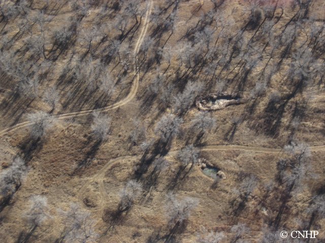
We headed east scouring the land below us as our pilot kept the plane steady and slightly tilted to the right so I could examine the wetland features while Joanna snapped hundreds of pictures like these from the back seat. 


The ride was smoother than expected, but the further east we traveled the more the Colorado wind decided it wanted to join the party. While it was not overly turbulent, it was enough to impair my ability to concentrate. We made an unscheduled stop in Brush, CO for a pit stop and to get our “land legs” back under us. While this was a nice break, I soon realized I was past the point of no return. Ten minutes back in the air and..…well..…let's just say I revisited previous meals. The next hour and a half flight back was less fun than the hour out, but David pulled us up to 1000+ feet which smoothed out the ride a bit. 

So why were we flying over the plains in December to look at wetlands? The timing just worked out that way, but actually yielded a few unforeseen benefits and a few surprises. First, although I use aerial photographs to map the wetlands in the first place, these are all taken looking straight down. By flying around we were able to get the 3D version of the landscape and use the oblique (slightly from the side) perspective to really get some good information about scale and topography. Secondly, without leaves on the trees (cottonwoods mostly) the understory becomes visible.


 This is important for deciding how wet an area is by how vigorous the vegetation growth is. The biggest surprise was, while December is a pretty low water time for river systems in Colorado, there was some extensive flooding in certain fields. It seemed like an odd time to be irrigating, so we are wondering what is happening here. 


While the flight time of three hours round trip was nothing extraordinary, I needed the full day and night to recover. I guess people get used to it, but I was having some difficulty. But the trip was a huge success as I was able to narrate about the wetlands to the passengers, discuss with Joanna (while in the air) troublesome patterns and specific features, and utilize the 386 pictures taken to further the accuracy of the areas I had been mapping. Joanna was gracious enough to not take a picture of me after the ride, lest viewers think I was a dancer in Michael Jackson’s Thriller. 

A big thank you goes out to our pilot David for his time, effort, and supply of ziplock bags, Lighthawk for their organization and what they do for the sciences, Joanna for her tolerance and strong stomach, and our STPC board member Greg for his company and questions.