Tuesday, December 29, 2009

Site profile: Indian Creek Hogback, Larimer County

B2: Very High Biodiversity Significance

Indian Creek Hogback Potential Conservation Area

This site was visited during our Larimer County Inventory of 2004. The red sandstones of the Fountain Formation overlain by Ingleside Formation form the hogback cliffs that are the dominant feature of this site. These cliffs extend at least six miles from Devil's Backbone to Horsetooth Reservoir. The dominant vegetation along the cliffs is mountain mahogany (Cercocarpus montanus) with a variety of native grasses. Bell's twinpod (Physaria bellii), a globally imperiled (G2/S2) plant, is found patchily throughout the site. Where it occurs, it grows from the base of the cliff to the toe of the slope and is most abundant where vegetation is sparse such as in areas of active erosion. This site supports a good (B-ranked) occurrence of Bell's twinpod. The species is known only from shale or sandstone hogbacks along the foothills of the Front Range from Jefferson County north to near the Wyoming border. Bell's twinpod has long been considered to be primarily restricted to Niobrara shale, so occurrences on Fountain and Ingleside formation sandstones such as within this Potential Conservation Area are little studied.

Physaria bellii
Bell's twinpod (Physaria bellii) in fruit

Thursday, December 24, 2009

Season's Greetings

Happy Holidays from all of us here at CNHP!


Thank you for making our new blog a success.  Here's to another year of continuing collaboration and conservation achievements as we carry on the work of documenting the biodiversity of our beautiful state!

Tuesday, December 22, 2009

Introducing the Peggy Lyon Collection at the Ft. Lewis Herbarium

CNHP Botanist Peggy Lyon has donated her personal flora collection representing over 480 species to the Mountain Studies Institute. The Peggy Lyon Western Colorado Flora Collection is to be housed at Fort Lewis College in Durango, Colorado. The Fort Lewis College herbarium is an internationally registered collection with current holdings of approximately 15,000 specimens of vascular plants and fungi, principally from southwest Colorado and the San Juan Mountains.

Peggy Lyon
Peggy the Explorer

The Peggy Lyon Collection represents vascular plants from throughout Colorado's western slope, collected by Peggy from 1993 through 2008. Following in the footsteps of intrepid lady botanists of years gone by (e.g., Alice Eastwood and Kate Brandegee), Peggy is leaving a lasting legacy of her tireless efforts to identify and catalogue the flora of western Colorado.

Thursday, December 17, 2009

Field methods - field photography

Some of the rare plant species that CNHP keeps track of are not only low in numbers, but also in stature. When we document locations of these species, we often make a photo record as well. For some reason, the most diminutive species often seem to require comparison with a common object in order to fix their true size in our consciousness. In other situations, we may want to record the dimensions of a feature that is key in plant identification.


Measuring the spines on a hawthorne

Although the most useful technique would probably be to carry a small ruler that photographs well in all light conditions, and is easy to clean, it appears to be more common to use a variety of objects from one's pockets. For example;

The classic Swiss army knife -


Botanist's hand lens -


Spare change -


...and, of course, snacks -

Tuesday, December 15, 2009

Site profile: Mineral Creek, Hinsdale County

B2: Very High Biodiversity Significance

Mineral Creek Potential Conservation Area

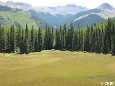
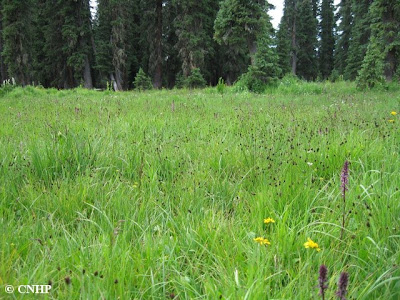
This site was visited during our Hinsdale County wetland survey, and features a small, isolated fen wetland in the La Garita Wilderness. The site is a closed-basin, lake-fill peatland with multiple small inlets and rivulets throughout, and has a large area of floating mat towards the center and grounded peat accumulations along edges. The fen supports an excellent (A-ranked) occurrence of the globally imperiled (G2/S1S2) mud sedge (Carex limosa) montane wetland community, as well as a good (B-ranked) occurrence of the globally vulnerable (G3/S3) woolly sedge (Carex pellita) montane wet meadows community. These two herbaceous communities form a mosaic where Carex limosa dominates the central floating mat, covering approximately 35% of the wetland, and Carex pellita dominates the surrounding extensive area of grounded peat mat. Uplands to the west of the wetland grade to steep talus slopes and those to the east have mixed quaking aspen (Populus tremuloides) and Engelmann spruce (Picea engelmannii) forest that slopes down towards Mineral Creek.

Carex limosa
Carex limosa at Mineral Creek PCA

Thursday, December 10, 2009

New CNHP Online Giving Page

'Tis the giving season, and our website now has a direct link to a CSU/CNHP online giving page for folks who wish to donate directly to CNHP.  We are a non-profit organization and donations are tax deductible.


If you'd like to make a donation to our Program, click on the "Donate Now" button on the upper left of our website.

You can choose to pay securely with a credit card online or print out a form to mail in with a check. In the future, we hope to also add our CSU Capital Campaign endowments as optional funds for people to select as the recipient of their donation.  Stay tuned!

Tuesday, December 8, 2009

Beaver - Castor canadensis

Beaver (Castor canadensis) are found throughout Colorado, sometimes even in urban areas. These large members of the rodent family are well known for their ability to change and control the hydrology of the streams where they live.

beaver lodge
Typical beaver pond with lodge in Hinsdale County, Colorado.

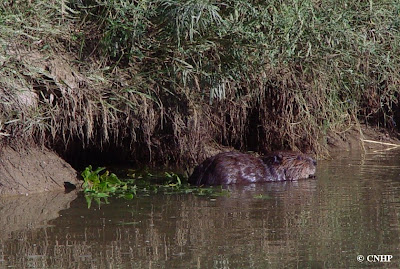
Although beaver dams and ponds are a common landscape feature in many of Colorado's higher mountain valleys, we don't usually think of finding them in the canyons of the eastern plains. CNHP Zoologist John Sovell took these photos of a beaver next to its den in the bank of a small stream in southeastern Colorado.

beaver next to bank den
Close up of a beaver next to its muddy bank den.  No gorgeous mid-stream lodges here!

beaver in SE Colorado
Off to find some lunch...

Here, instead of majestic aspen and mountain willows, a beaver must make do with coyote willow and cottonwood saplings.

beaver habitat in SE Colorado
What passes for beaver habitat in the riparian areas of the southeast plains of Colorado.

Thursday, December 3, 2009

Conservation Action Planning


CNHP Conservation Planner Lee Grunau recently conducted a 2 day training session for the City of Fort Collins Natural Areas on Conservation Action Planning (CAP). CAP is a process developed by The Nature Conservancy that provides answers to a core set of questions critical for the success of any conservation project, such as:

  • What is the biodiversity of interest and its status?
  • What threats exist and what is their importance?
  • Which stakeholders should be engaged, what underlying causes and opportunities warrant attention?
  • What specific outcomes are we trying to achieve?
  • What actions are we taking to achieve the desired outcomes?
  • How do we know if our actions are working?
  • How can we adapt and learn and share results to achieve impact at broader scales?

A CAP is an iterative and adaptive process that looks at conservation targets at multiple spatial scales in order to be as effective as possible with the knowledge and resources available. Since the process was developed, over 300 CAP plans have been completed in North America, Latin America, and the Asia Pacific. CNHP has used the CAP protocol on several of our own projects.


In addition to having a CAP trainer on staff, CNHP has also developed analysis techniques to determine conservation target viability and landscape condition, and to measure levels of conservation effectiveness (see our draft Biodiversity Scorecard for more information). Our BIOTICS database contains thousands of tracked element occurrence data points that are integral to conservation planning efforts throughout Colorado. Need help with conservation planning? Give us a call!

Tuesday, December 1, 2009

Conservation large and small

As a sponsored program at CSU's Warner College of Natural Resources, CNHP is funded exclusively by grants from our partners (i.e., sponsors). Each year we work with a variety of federal, state, and local government agencies, as well as non-profit organizations of both local and national scale. In the past 10 years, we have partnered with about 70 different sponsors, and our annual grant award totals averaged $1.8 million.

CNHP grant awards by fiscal year

CNHP is pleased to work with many partners who have small budgets to contribute to the conservation of Colorado's elements of biodiversity, and not just with partners who have funding for multi-year, large scale projects. We have averaged 55 grants per year during the past 10 years, and about 30% of each year's awards are for less than $10,000.

Number of grants by dollar amount FY00-FY09

Tuesday, November 24, 2009

Field techniques - percent cover estimation

If you've read any descriptions of ecological communities you may have noticed that the species composition is often expressed as percent cover. CNHP ecologists and botanists make frequent use of this measurement during field surveys of the habitats of rare plants or animals, as well as using the numbers to describe plant community occurrences.

Cover is usually measured as either basal cover – the area that the stems of plants cover on the ground, or aerial cover – sort of the bird's-eye view of how much ground is obscured by vegetation. Percent cover can be measured with a variety of techniques and equipment, most of which are expensive in terms of time and/or money. Visual estimation of cover is quick, but has the potential to introduce observer bias. Most of us have no trouble distinguishing between 1% cover and 50% cover, but when faced with assigning a percentage to an un-measured plot, our estimates can vary widely.

Field ecologists often have to "re-calibrate" their eyes at the beginning of the field season, or when training new crew members by using careful measurements of sample plots. Here are three examples of different cover levels between 1% and 50%. See if you can match the correct percent to each example from the following choices: 1%, 3%, 5%, 10%, 15%, 20%, 50%.

(A)

(B)

(C)

Answers appear below (keep scrolling).


(A) = 10% (B) = 3% (C) = 20%

How well did you do?

Thursday, November 19, 2009

Fen surfing

CNHP wetland ecologist Joanna Lemly took this footage of ecologist Denise Culver investigating an example of a "quaking" fen this summer in Jackson County. Denise is standing on a floating mat of vegetation. These mats are a typical feature of peatlands formed in groundwater-fed basins, and consist of living plants rooted in an accumulation of peat formed from the water-logged remains of dead plants. These mats are often strong enough to walk on, although it may be a bit of a challenge to keep your balance and avoid breaking through to the water below. In contrast to their physical instability, these quaking communities are generally ecologically stable, because they can adjust to fluctuating water levels.

Tuesday, November 17, 2009

Our team pages are now complete

Since our new website debuted back in July, we've been doing our best to fully flesh out our new website with useful information and meaningful content. One of the new features of our website is a separate page for each of our teams.

CNHP is made up of five separate disciplinary working teams. Our teams work very closely together, and virtually all CNHP projects utilize staff from multiple teams. But, in order to highlight the specialties of each team, we have created a page for each, and all of them are now complete! Check them out!

Thursday, November 12, 2009

New location for Salix candida in North Park

CNHP ecologist Denise Culver found a new occurrence of sageleaf willow (Salix candida) while working near the Canadian River in North Park this summer. This is the first record of the species in Jackson County, Colorado.

Salix candida
Salix candida, the sageleaf willow


This willow is fairly common in more northern (boreal) latitudes of North America, but is also found in rare isolated populations in Colorado, Wyoming, and South Dakota. In these areas, the species has remained as a relict from the previous glaciation, when what is now typical boreal vegetation was found much further south on the continent. Throughout its range, Salix candida is typically associated with fens, bogs, marshes, and other areas of permanently saturated soils where peat is present. Although globally secure (G5 rank), the species is considered imperiled (S2 rank) in Colorado. Sageleaf willow is also considered a sensitive species for the U.S. Forest Service in the Rocky Mountain Region.

Tuesday, November 10, 2009

Wetland Ecological Integrity Assessment report available


Ecological Integrity Assessments (EIAs) are multi-metric indices designed to be employed as either rapid or intensive assessments of wetland ecological condition. Practical and ecologically meaningful biotic and abiotic metrics are selected to measure the integrity of key ecological attributes. These indicators are rated and then aggregated into an overall score for four major ecological categories:
  1. Landscape Context,
  2. Biotic Condition,
  3. Abiotic Condition, and
  4. Size.

The ratings for these four categories are then aggregated into an Overall Ecological Integrity Score for each site. These scores can be used to evaluate current wetland condition and track change toward management goals and objectives.

Funded by the U.S. Environmental Protection Agency, the Colorado Natural Heritage Program developed seven EIAs for wetland types in the Southern Rocky Mountain Ecoregion. This project field tested the Subalpine-Montane Riparian Shrublands EIA in the Blue River watershed of Colorado.

The final report; Field Testing of the Subalpine Montane Riparian Shrublands Ecological Integrity Assessment (EIA) in the Blue River Watershed, Colorado, is now available on our reports page.

Thursday, November 5, 2009

A Summer At Home

by Dawson White

During the summer of 2009 I had the privilege of being a botany intern of the Colorado Natural Heritage Program (CNHP), and I do mean privilege. Over the course of 10 weeks, western-slope field botanist Peggy Lyon was my personal mentor in all things Plantae. As a born naturalist and emerging botanist, this was the best job I have ever had.


Dawson hanging over Unaweep Canyon, where he updated an occurrence of Heuchera rubescens (pink alumroot), a critically imperiled (S1) species in Colorado.

The western slope, specifically the San Juans, had been home all my life prior to coming to Colorado State University. For three years, I was lucky enough to study as a botany field intern for the Andes to Amazon Biodiversity Project in southeastern Peru, and so was not able to see much of my treasured western Colorado. This past summer (2009) I was longing for a good dose of Colorado bluebird-days. After meeting with CNHP Director Dave Anderson and Botany Team Leader Jill Handwerk, I knew I was going to be exposed to some of the most magnificent terrain western Colorado has to offer; and even more exciting, I would be working under one of the top field botanists of the region, Peggy Lyon.

Rare Plant Surveys and monitoring projects were our focus, contracted through various organizations, including the BLM, Forest Service, The Mountain Studies Institute, and The Nature Conservancy. These contracts took Peggy and me to some of the most beautiful places in the West, ranging from the top of spectacular peaks near Telluride, to the Colorado River at the Utah border, the lowest point in western Colorado. I spent every week in a tent in the sticks, right at home, and would return to Telluride on the weekends to get cultured alongside the old friends.


Dawson setting up a monitoring plot for Physaria pulvinata in Lone Mesa State Park.

Needless to say, I saw several bluebird-days, each better than the previous. But my biggest feeling of accomplishment came from the wealth of knowledge I gained about our native flora and the conservation initiatives that are being realized because of our efforts. In addition to the rare plants we were tracking, we would make a complete species list of every site we visited, just for fun. At this point my Weber (Colorado Flora) is tattered and brown, a great sight. I learned a large portion of our native plants and can quickly identify any plant to family, and usually genus and species too.

Our surveys and monitoring projects were essential in the progression of conservation and stewardship of our western Colorado lands. The Dominguez Wilderness, for example, was recently granted wilderness status and it was the job of CNHP to produce the regional rare plant report so that the BLM could establish a reasonable buffer zone. Not many individuals can say he or she has successfully helped to conserve a speck of our diminishing wild lands, but thanks to the chance to work with dedicated and talented scientists and professionals at Colorado Natural Heritage Program, I can say that my work helped enact historical conservation legislation! This is an organization that deserves all of our support; for the success of this institution means the success of environmental consciousness and stewardship.

Tuesday, November 3, 2009

CNHP alumnus in the news!

Katie Driver, one of our recent seasonal field botanists and current CSU graduate student, was honored with the 2009 Rocky Mountains Cooperative Ecosystem Studies Unit Student Achievement Award for her work in creating a protocol for monitoring wetlands in Rocky Mountain National Park.

It was the Colorado National Heritage Program that gave Katie her first full-time seasonal field botanist position. "Here, I was able to really develop my plant identification skills and my knowledge of Rocky Mountain vegetation communities," said Katie. Her work with the Colorado Natural Heritage Program gave her the opportunity to work in both Rocky Mountain National Park and Great Sand Dunes Park and Preserve collecting plant species data to help create park vegetation maps. Katie then went on to become a graduate student with Dr. David Cooper in the Warner College of Natural Resources (the same college where CNHP is based here at CSU), where she developed her award-winning wetlands monitoring protocol. See the full CSU press release here.

Congratulations, Katie! We foresee a long and distinguished career in ecology.

Thursday, October 29, 2009

Boulder County Parks and Open Space looking for volunteers

Our friends at Boulder County Parks and Open Space have a new ongoing volunteer opportunity monitoring shrub habitats. Boulder County has abundant shrub habitats in varying conditions at their foothills properties (Hall Ranch, Heil Valley Ranch, Rabbit Mountain).

Monitors will track shrub health relative to climate, browsing, and fire interval on Boulder County open space properties. Some general qualifications include knowledge of plant identification or natural resources background, experience with line and point transect monitoring, scientific method and the ability to keep computer records.

For more information about this opportunity, visit this page (scroll to the bottom of the document), or contact Michael Bauer at mbauer@bouldercounty.org, 303-678-6219.

The Colorado Natural Heritage Program recently did an extensive county-wide inventory of Boulder County. Our report, Survey of Critical Biological Resources in Boulder County, Colorado, is availabe on our reports page, under "2009 Documents and Reports".

Tuesday, October 27, 2009

Following pallid bats in canyonlands of southeastern Colorado

telemetered Antrozous pallidus
Pallid bat (Antrozous pallidus) with attached telemeter (gleaming line behind the bat is the antenna from the transmitter)

The pallid bat (Antrozous pallidus), like most bats in North America, feeds on invertebrates, but pallid bats are one of the few that takes a considerable proportion of their meals off the ground or vegetation. Pallid bats can sometimes be found landing on the ground to capture and eat terrestrial arthropods, like scorpions, centipedes, spiders and grasshoppers. Pallid bats are mainly nocturnal, and during the day can roost in large aggregations of hundreds of individuals. Most often, however, day roosts contain solitary bats or small groups of individuals in caves, mines, cracks or buildings.

Antrozous pallidus roost
Jeremy Siemers sitting above a boulder where a pallid bat is roosting (the bat is in the crack in the foreground)

CNHP Zoologists Rob Schorr and Jeremy Siemers spent this summer trying to determine what areas male pallid bats use during the day. As the sun set near the Purgatoire River in Las Animas County, Rob and Jeremy extended mistnets over cattle troughs in hopes of catching bats flying in for a drink. Twelve male pallid bats were captured over several troughs, and Rob and Jeremy carefully attached radiotelemeters to each one. The radiotelemeters emitted high frequency sound that could be tracked using specialized antennas and receivers.

Antrozous pallidus telemetry
Rob Schorr and telemetered pallid bat

Rob, Jeremy, graduate student Jessica Healy, and technician Catherine Gearhart tracked these 12 pallid bats to approximately 50 roosts. Most of these roosts were in tall, vertical cracks in rock wall cliffs, but a few were in the cracks of large boulders. Some roosts were home to multiple bats and on two occasions one of the telemetered bats was found using a roost previously occupied by another telemetered bat. What became apparent over the course of tracking the pallid bats is that the bats selected cliff roosts that were difficult for humans to access. On more than one occasion researchers had to backtrack after reaching perilous cliff walls or drop-offs. As Rob and Jeremy analyze this summer's data, it will be interesting to discover if the roosts of these 12 bats display similar characteristics.

pallid bat roosting habitat
Jeremy Siemers peers from one of the cliff wall cracks near a pallid bat roost

Thursday, October 22, 2009

North Platte Watershed Wetland Assessment crew wraps up field season

CNHP ecologist Denise Culver and her colleagues spent a good part of the summer in Jackson County in north-central Colorado, looking at important wetlands of the North Platte watershed. The study was funded by the North Platte Basin Roundtable and the Colorado Water Conservancy Board and was designed to assist the Roundtable’s Non-consumptive Needs Assessment committee in meeting their overall goal of identifying important non-consumptive uses in the watershed. “Non-consumptive use” means water used to support wildlife, recreation (fishing, hunting, wildlife viewing, boating) and habitat, as opposed to “consumptive use” which has historically been used to mean water used for agricultural, municipal and industrial benefits.

Wetland soil pit
 Denise digging a soil pit, or a mud pit, as the case may be.

The survey will provide the citizens of the North Platte River Watershed with scientific data on the range of wetland dependent plants and animals. These results can be used to assist land use planning and management efforts and to balance the needs of natural resources and water developments. Additionally, the results from individual properties can be utilized by the landowners as a baseline for future conservation options.

badgers
A family of badgers wonders what an old survey flag is doing in the middle of their territory (sorry guys).


The North Platte watershed supports every wetland type known in the Southern Rocky Mountain ecoregion, including riparian wetlands (willow carrs), fens (peat accumulating and ground water fed), alkaline flats, and freshwater marshes. These wetland complexes are presently intact and contiguous, providing migration corridors and habitat for animals (including aquatic vertebrates and invertebrates). Prior to the project, very little was known about the wetlands on private lands within the watershed.

Colorado fen
Example of a fen in the North Platte watershed.

sandhill cranes
A pair of sandhill cranes hanging out in a wet meadow.
Migration corridors are extremely important for these and many other birds.


To date, CNHP has had access to over 186,000 privately owned acres, or about 44% of the private land in the watershed. Preliminary results confirm the importance of private lands that support intact, contiguous wetlands in excellent condition. These wetlands make important contributions to the health of aquatic systems by purifying water, filtering runoff, abating floods, and decreasing erosion, as well as providing habitat for wildlife, fish, waterfowl, and amphibians. During the course of the summer we met many landowners and managers who are concerned about the future of the North Platte and its tributaries. Their best management practices, already in place, indicate good stewardship of their lands and water, which is important not only for their property but also for private and public lands downstream.

juvenile boreal toad
 A young boreal toad makes a break for its wetland home...

 juvenile wood frog
…while a juvenile wood frog contemplates its options.

Tuesday, October 20, 2009

Preble's meadow jumping mouse at the U.S. Air Force Academy

Zapus hudsonius preblei
A Preble's meadow jumping mouse (Zapus hudsonius preblei) after being released

For 12 years, the Colorado Natural Heritage Program has been helping the U.S. Air Force Academy monitor and manage the populations of Preble's meadow jumping mice (Zapus hudsonius preblei) found on the Academy. One tool CNHP is using is a long-term mark-recapture study of the Preble's mouse population inhabiting the riparian shrublands along Monument Creek.


Monument Creek
Monument Creek and the adjacent shrublands inhabited by Preble's meadow jumping mice

Each summer researchers return to the same sections of Monument Creek to capture and mark individual Preble's mice. By marking new individuals and recapturing previously tagged individuals, researchers can estimate population parameters, such as survival and abundance. This year, CNHP zoologist and project lead Rob Schorr was accompanied by zoologist Bobby Weidmann and volunteer Molly McGee. Rob has been coordinating the trapping since its inception in 1999, and Bobby returned to the Academy after helping Rob sample in 2004 and 2005. Molly made her first visit to the Academy while on summer break from Furman University in Greenville, South Carolina.


Molly McGee and Rob Schorr in the shrublands of Monument Creek

 Rob Schorr with Preble's meadow jumping mouse
Rob Schorr pointing out the distinctive large hind feet and long tail of the Preble's meadow jumping mouse

Thursday, October 15, 2009

Rocky Mountain ReMAP project


 The multi-state ReMAP project team lays out a survey plot during pre-season training in Lander Wyoming.

CNHP is partnering with the Montana Natural Heritage Program and the Wyoming Natural Diversity Database on an exciting large-scale project that will aid all three states in refining wetland condition assessment methodology. The project, funded by the EPA’s Regional Monitoring and Assessment Program (ReMAP for short), is called the Rocky Mountain ReMAP project and provides an opportunity to compare wetlands across the Rocky Mountains.


Over the course of the three-year project period (2008-2011), the project will:
1.  Identify reference standards for six wetland ecological systems found across the Rocky Mountain region
2.  Develop Level I, II and III protocols for evaluating the ecological condition of six wetland ecological systems throughout the study area.
3.  Produce a regionally standardized method for assessing and monitoring wetland condition, including quality assurance project plans, sampling strategies, and metrics calibrated to the six different wetland ecological systems.


 Linda Vance, project lead from the Montana Natural Heritage Program, discusses protocols for estimating bankfull width during pre-season training in Lander, Wyoming.

Data collection for this project began this past field season, and will continue through next year. The CNHP field crew traveled to wetlands throughout the mountainous portions of Colorado, including the West Elk Mountains near Gunnison, the Sawatch Range near Buena Vista, and the Mt. Zirkel Wilderness near Steamboat Spring. Though they put many miles on the field vehicle, CNHP crew members Elin Franzen and Hannah Varani, both recent CSU graduates, were thrilled to see so many different and beautiful wetlands across the state.


CNHP ReMAP field crew member Elin Franzen prepares to survey a high elevation marsh in Chaffee County.

Tuesday, October 13, 2009

Renée Rondeau receives award from CSU

CNHP Ecologist and Conservation Planning Team Leader, RenĂ©e Rondeau, was presented with an award on October 6 for her outstanding role as Staff Co-Chair for the 2008-2009 CSU Faculty-Staff Drive.  This annual fund drive raises money for important CSU programs, including non-profit programs within the University, such as the Colorado Natural Heritage Program. It also provides a critical yardstick for outside funding agencies to evaluate how well those of us within the University believe in and advocate for the opportunities we offer.

Renée Rondeau receives award from CSU
From left to right: Ken Wilson, Fish, Wildlife, & Conservation Biology Department Head; Warner College of Natural Resources Dean Joe O'Leary; Renée Rondeau; Sara Colorosa, Assistant Director of Annual Giving, University Development; and Scott Webb, WCNR Director of Development.

As Staff Co-Chair, RenĂ©e shared why she believes Colorado State University is such a wonderful place to work, teach, and learn.  She visited donors, thanking them personally for their contributions to CSU, as well as voicing her support in the Drive brochure and thank-you letters. 

"It was a true pleasure working with her." said Sara Colorosa, Assistant Director of Annual Giving for CSU, who presented Renée with the award during CNHP's most recent staff meeting.

Renée Rondeau receives award from CSU
Renée tells Scott Webb and Sara Colorosa why she is passionate about her work and why charitable giving for causes you believe in is so important.

Thursday, October 8, 2009

CNHP awarded EPA Wetland Program Grant

Colorado Wetlands

We are thrilled to announce that CNHP has been awarded $550,832 from the U.S. Environmental Protection Agency (USEPA), Region 8, Wetland Program Development Grant Program. The award funds three projects that support EPA’s Strategic Plan and contributes to Colorado’s Wetlands Strategy.

The first project, Tools for Colorado Wetlands: Essential Information for Identification, Assessment, and Conservation, will develop a Colorado Wetland Field Guide that will contain botanical descriptions of over 500 wetland plants as well as information on priority wildlife species and other wetland-dependent animals, wildlife and vegetation ecology, and rare and/or sensitive plants. The Guide will serve as the ultimate resource to determine a wetland plant’s identity, wetland indicator status, coefficient of conservation, rarity, and ecology. The project will also develop an easily accessible Colorado Wetland Website that will provide a virtual “one-stop shopping” for wetland information in Colorado, including:
  • Information on wetland ecosystems and their conservation status,
  • a database to calculate the overall conservatism of species present in a wetland,
  • reports on Colorado wetland and wetland assessment tools, and
  • links to other wetland projects and programs
Colorado Wetlands

The second project, Setting Mitigation in the Watershed Context: Developing a Multi-tiered Approach to Improve Compensatory Mitigation will be conducted in partnership with CSU’s Department of Biology. This project will develop protocols for improving compensatory mitigation decisions by placing them within a whole watershed context, considering both gross changes to the abundance of wetland types and the condition of existing wetlands. A pilot study area will include a key portion of the rapidly developing northern Front Range I-25 corridor. This project will create:
  • A rational framework for developing wetland profiles throughout Colorado for mitigation purposes,
  • mapping and trend analysis of wetland cumulative impacts, along with characterization of current wetland condition within the pilot study area, and
  • a general framework for placing mitigation in the landscape context in Colorado.
Colorado Wetlands

The third project, Survey of Critical Wetlands and Riparian Areas in Teller County, will build upon CNHP’s effort to document and assess Colorado’s rare and/or imperiled plants, animals, and unique plant communities since 1992. This project, in partnership with Teller County and the Coalition for the Upper South Platte (CUSP), will perform a prioritized survey and conditional assessment of the County’s wetlands, including geographically isolated wetlands. The survey will provide a proactive approach for land managers and decision makers in rapidly growing areas within the County.

10/28/2009 Update: Here is the official press release from CSU.