Wednesday, November 28, 2012

This Weekend: Drink a beer, help a rare plant!

Even while Colorado's globally imperiled wildflowers are dormant, we continue to strategize for their long-term protection. Pateros Creek Brewing Company has graciously agreed to help us celebrate these remarkable plants by brewing a specially crafted Extra Pale Ale named for the listed Threatened Ute’s Ladies-tresses Orchid (Spiranthes diluvialis): Spiranthes EPA!

This Weekend (11/30 - 12/02) only!
$1 per pint of Spiranthes EPA sold through the weekend will benefit the Colorado Rare Plant Conservation Initiative!

Not to worry, there isn't actually any Spiranthes in the beer.

For some extra special fun, please join CNHP staff this Friday, 11/30, from 5-8 at Pateros Creek for a special release party for this excellent beer (we've sampled it and recommend it highly!). Pateros Creek Brewing Company is located northeast of College Ave and Pine St in Old Town, Fort Collins. They do not serve food, so we will provide appetizers. Live music by Shaefer Welch of Rosewood Divine.

Wednesday, November 21, 2012

Lake Mead vegetation mapping project begins!

Joe Stevens recently traveled to Boulder City, NV to attend the kick-off meeting for the Lake Mead National Recreation Area (LAKE) Vegetation Mapping Project. The LAKE Vegetation mapping project is funded by the National Park Service under their effort to complete vegetation inventories at nearly all of the National Park units. The project at LAKE began in 2010 with the collection and classification of field plot data by the California Native Plant Society. Analysts from the Bureau of Reclamation are currently performing Image interpretation and mapping.

The Semi-Desert Wash Woodland/Scrub Map Class dominated by Ericameria paniculata and Chilopsis linearis,
with Creosote bush and Semi-Desert Scrub map classes on the hillsides in the background.

The Yucca Shrub Map Class with Yucca schidigera, Ambrosia dumosa, Eriogonum fasciculatum,
Cylindropuntia echinocarpa, and Larrea tridentata.

Following release of the completed map in the fall of 2013, CNHP will conduct accuracy assessment (AA) field sampling to quantify the map accuracy. AA field sampling will entail collecting 1,000 or more field plots and will require several crews working for several months. Hiring for those positions will be in the fall of 2013.

Wednesday, November 14, 2012

Mesa Verde cactus 20-year demographic study published

Results of a 20-year study of the Federally Listed (Threatened) Mesa Verde cactus (Sclerocactus mesae-verdae) were recently published in the journal Western North American Naturalist. CNHP ecologist Karin Decker co-authored the paper, along with Janet Coles and Tamara Naumann, both of the National Park Service.

Mancos shale - favorite habitat of Mesa Verde cactus.

Funded by the US Fish and Wildlife Service through the Colorado Natural Areas Program, the study followed individually marked cactus plants over the period from 1986 to 2005. Each year, researchers measured every cactus stem in 3 different plots in southwestern Colorado, and recorded reproductive status and damage or mortality. A total of 1629 stems were measured. At least 30 cactus plants lived through the entire study period and were still going strong when last observed. Clearly, twenty years may not be long enough for the study of some long-lived species! Read the abstract here.

This little plant is about 4 cm (1.6 inches)  in diameter, and probably at least 7 years old.

Mapped locations of rare and imperiled species and natural communities in CNHP’s database doubles in the past decade


CNHP strives to have the most comprehensive database of rare and imperiled plants, animals and unique natural communities (referred to as “elements of biodiversity” or “elements”) in Colorado. We compile data from our own field surveys and county inventories, and collect data from key partners and other professionals in the conservation community. It is nearly impossible to survey the entire state, but as a collective, we can build a comprehensive database that serves Colorado and ensures that the complex challenges of the 21st century are tackled thoughtfully and informatively.

See our latest tracking list here. If you have data for any species we track, please complete a CNHP field form and submit your data to our repository. You can download CNHP field forms or fill them out online at the CNHP data submission page.

Thanks to Colorado’s conservation community, our database has grown from 11,500 mapped locations of rare elements in 2000 to over 25,000 mapped locations in 2012. Help us double this again in the coming decade!

Graph of the number of rare and imperiled species and natural communities
that have been mapped by CNHP during the 2000 - 2012 period.

Wednesday, November 7, 2012

Pop Quiz! Can you identify these anthropogenic disturbances from aerial photos?

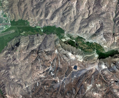
Identifying anthropogenic disturbances from aerial photos can be tricky, but it is a regular feature of some of our work at CNHP. See if you can identify the disturbances by taking the quiz below. Answers at the bottom of the post.

1. What caused the bald patches shown in these photos?


2. What are the white dots?


3. What is the dark smudge in the center of this photo? What about the black square and rectangles?


4. What causes the dense road patterns in both of these photos?


5. What are the diagonal lines shown here?


6. What are the rectangles in the middle of this photo? What about the circle and half-circle below?

Bonus Question: how big are the circles?
 7.  What is the black object? Close up below.


Close up
8. What causes the white and green diagonal stripe pattern? What are the white objects along the curvy roads?


Scroll down for the answers...


Quiz answers:
1. Both of the bald patches were caused by fires.  The top photo is the 1978 Ouzel fire in Rocky Mountain National Park and the bottom photo is the 1996 Buffalo Creek fire in Jefferson County.
2. Cemetery - the white dots are gravestones.
3. The dark smudge in the center of the photo is a heap of coal - this is a photo of the Hayden power plant in northwestern Colorado.  The black square and rectangles are ash ponds.
4. The dense road patterns are caused by oil and gas development.
5. Power lines.
6. A solar farm - the little rectangles are solar panels.  The circle and half-circle are crops irrigated by center pivot sprinklers. Bonus answer: each center-pivot system occupies a quarter of a section (a section is usually 1 square mile) so each circle has a diameter of about a half mile.
7. The black object is a uranium tailings "disposal cell" - the surface is covered with dark rocks.
8. In this farm field the green stripe is being farmed (dryland wheat) while the tan stripe lies fallow which allows the soil to regain nutrients.  The white objects along the curvy roads are wind turbines.