Monday, July 30, 2012

Summit Lake Park


Earlier this month, CNHP director Dave Anderson, ecologist Denise Culver, and botanist Jill Handwerk visited the Summit Lake Park to help Denver Mountain Parks and the Colorado Native Plant Society document the vegetation in the area.

To help give you an immersive experience of actually being there, put an ice cube tray in front of a fan and sit in front of it.

This park on Mount Evans is also a National Park Service National Natural Landmark. This is a good place to see a number of wildlife species, including large mammals:

These bighorn sheep are apparently taking over for the far-more-frequently-seen-except-when-we're-there mountain goats while the goats are on lunch break.

And, smaller mammals:

A typical alpine resident, the yellow-bellied marmot, seeing what those crazy botanists are up to.

Mt. Evans is also home to several species of rare alpine plants:

Koenigia islandica, with a pencil point for scale. This arctic plant is rare in Colorado.

Draba exunguiculata, found only in Colorado.

These and other rare species share the park with many more common alpine species:

Claytonia megarhiza, the alpine spring-beauty.

Bistorta vivipara (=Polygonum viviparum), the alpine bistort.

And when the weather is good, the views are spectacular!

 The view from the ridge north of Summit Lake, looking into the Chicago Lakes Basin.

Tuesday, July 24, 2012

USFWS Recovery Champion Award Ceremony

By Susan Spackman Panjabi, CNHP Senior Botanist

From left to right: Brian Kurzel (CNAP), Betsy Neely (TNC), Susan Spackman Panjabi (CNHP), and Jenny Neal (DBG), holding their USFWS Recovery Champion Award plaques and letters. Photo by David Anderson.


It was an honor to stand beside Betsy Neely (The Nature Conservancy), Jenny Neal (Denver Botanic Gardens), and Brian Kurzel (Colorado Natural Areas Program) and receive the USFWS Recovery Champion Award, presented to us on July 20. While the four of us were singled out to receive special plaques, the award acknowledges the Colorado Rare Plant Conservation Initiative (RPCI) as a whole, including all of the RPCI partners as well as our important accomplishments over the past five years. The award ceremony was well attended and took place at the Middle Park Important Plant Area, in view of two endangered plants, Astragalus osterhoutii (Osterhout's Kremmling milkvetch) and Penstemon penlandii (Middle Park penstemon, a.k.a. "Kremmling's first settlers"). This was a great opportunity to highlight RPCI's work across the state, share our successes with national and state level decision makers, and credit our local partners who are essential to meeting our goals.

Rare plant habitat on Bureau of Land Management and State lands comprising the Middle Park Important Plant Area, near the town of Kremmling, in Grand county, Colorado. Photo by David Anderson.

It was also a thrill to receive letters from Senator Mark Udall and USFWS Deputy Director for Policy Gregory Siekaniec thanking me for my work with the Colorado Rare Plant Conservation Initiative and CNHP. Thank you to everyone who made the achievement of this award possible.


Astragalus osterhoutii (top) and Penstemon penlandii. The plants, while in abundance around the award ceremony, were not actually blooming at the time. So here are a couple of pictures taken in June a few years back. Photos by Susan Spackman Panjabi.

Wednesday, July 18, 2012

Southern Colorado (and northern New Mexico) Landscapes: Part 3

During their June overflight of the San Luis Valley and Southern Sangre de Cristo Mountains, Renée Rondeau and Lighthawk pilot Steve Paul also ventured south of the Colorado border to take a look at the Park Plateau and other landscapes in northern New Mexico.


On the border between Colorado and New Mexico, an extensive area of mesas and valleys on the eastern side of the southern Sangre de Cristo Mountains overlooks the grassy plains above the Cimarron River to the south. This is the Park Plateau, which is dominated by a matrix of montane woodland types interspersed with large grasslands or parks. The Park Plateau is home to the famous Vermejo Park Ranch, as well as the Valle Vidal Unit of the Carson National Forest.


Lorencito Canyon, near the border of Colorado and New Mexico. Some of the roads associated with energy development are visible amidst the ponderosa pine and mixed-conifer woodlands.

Looking over the shortgrass prairie to the east of the Park Plateau - three-armed Black mesa is visible in the upper right.

The edge of Eagle Tail Mesa. Slopes are wooded with pinyon-juniper, while shortgrass prairie covers the nearly flat mesa surface.

But it isn't all flat. In the middle of Eagle Tail Mesa is Eagle Tail Mountain. Here the mountain slopes support more pinyon-juniper, with a bit of ponderosa pine towards the top.

Before turning around to head back to the Park Plateau, Steve and Renée flew over the sharply demarcated canyon of the Canadian River.

Pinyon-juniper clad mesas flanking the Vermejo River. The Cimarron Range is on the horizon.

Further up the Vermejo River Valley - Vermejo Park is visible in the center distance, with the Culebra Range beyond.

Grasslands interspersed with ponderosa pine woodland. Some beetle-killed trees (brown) are visible on the right, but most ponderosa woodlands in the area appear to be in good condition.

The Valle Vidal, a beautiful montane grassland valley, flanked by aspen, mixed-conifer, bristlecone pine and spruce-fir forests.

And that wraps up our aerial tour of the San Luis Valley and surrounding landscapes. Thanks for joining us, and thanks once again to Lighthawk for the valuable service they provide.

Thursday, July 12, 2012

Southern Colorado Landscapes: Part 2

During a June flight with Lighthawk volunteer pilot Steve Paul, CNHP's Renée Rondeau got a tour of many of the ecosystems in the southern Colorado (Part 1, the San Luis Valley).

The Sangre de Cristo Mountains

The Sangre de Cristos are a steep, narrow mountain range along the eastern boundary of the San Luis Valley. The prominent massif of Blanca Peak anchors the central part of the range. Further south, the southern Sangre de Cristos are called the Culebra Range, and form the western boundary of the Park Plateau in northern New Mexico.

These mountains support narrow bands of shrubland, woodland, and forest types with increasing elevation, and include alpine and barren rock habitats at the highest elevations.

Slopes below Blanca Peak illustrate how vegetation types change with elevation in the Sangre de Cristos, from pinyon-juniper at the bottom to alpine at the top.

Above the pinyon-juniper, stands of aspen and mixed conifer dominate.

Near Whiskey Pass, spruce-fir forest clusters below the alpine tundra.

Second verse, same as the first. Once over the mountain ridge, on the east side of the Sangre de Cristos, we head back down through the different forest types. The Spanish Peaks are visible in the upper right.

Back down at the pinyon-juniper. The view north along the Stonewall, a volcanic dike that goes on for nearly 30 miles.

More to come in part 3, as Renée and Steve venture into northern New Mexico.

Tuesday, July 10, 2012

Southern Colorado Landscapes: Part 1

Last month Renée Rondeau had the opportunity to make an overflight of the San Luis Valley, southern Sangre de Cristo Mountains and the Park Plateau in northern New Mexico. Thanks to Lighthawk volunteer pilot Steve Paul, Renée got a birds-eye view of the diversity of ecosystems in the area.


The floodplain of the Rio Grande in the San Luis Valley, with Blanca Peak in the distance.


The San Luis Valley

Although much of the San Luis Valley floor is devoted to irrigated agriculture, the eastern portion is still dominated by native vegetation. The northern end of the San Luis Valley has no natural hydrological connection to the southern end, which is drained by the Rio Grande River and its tributaries. This “closed basin” is home to the Great Sand Dunes National Park and Preserve, where the dune field and the surrounding sandsheet shrublands and sabkha wetlands form a sparsely vegetated landscape along the eastern edge of the valley.

Great Sand Dunes National Park and Preserve
Medano Creek flowing along the edge of the dunes, where it disappears into the sand.

Great Sand Dunes National Park and Preserve
The dune field, with the Sangre de Cristo Mountains in the background.

Great Sand Dunes National Park and Preserve
A rolling dune gathers no moss (or other vegetation), but parts of the Great Sand Dunes have stayed still long enough to become partially vegetated. Here we see a view of the sandsheet shrublands, west of the dune field.

sabkha wetlands
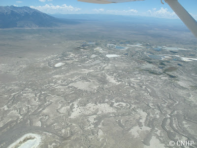
Sabkha wetlands at the "sump" - the bottom end of the closed basin.

Semi-desert shrub-steppe and the San Luis Hills.

Stay tuned for more in part 2 - when we fly over the southern Sangre de Cristo Mountains.


Wednesday, July 4, 2012

Happy Independence Day!

As we swelter in the record high temperatures here on the Colorado Front Range, here's a photo of a nice cool place to take your mind off the heat.

 A red, white, and blue display by paintbrush, bistort, and bluebells in the alpine. Aaah.

Stay safe and cool, and have a happy Fourth of July.